
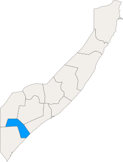
Lower Shabelle is an administrative region (gobol) in southern Somalia.
Middle Juba is an administrative region (gobol) in southern Somalia. With its capital at Bu'aale, it is located in the autonomous Jubaland region.

Lower Juba is an administrative region (gobol) in southern Somalia. With its capital at Kismayo, it lies in the autonomous Jubaland region. It has green forests and wild life animals such as lions, giraffes, hippos, crocodiles, and hyenas.
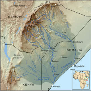
The Jubba River or Juba River is a river in southern Somalia which flows through the autonomous region of Jubaland. It begins at the border with Ethiopia, where the Dawa and Ganale Dorya rivers meet, and flows directly south to the Somali Sea, where it empties at the Goobweyn juncture. The Jubba basin covers an area of 749,000 km2 (289,000 sq mi). The Somali regional state of Jubaland, formerly called Trans-Juba, is named after the river.
The Shebelle River begins in the highlands of Ethiopia, and then flows southeast into Somalia towards Mogadishu. Near Mogadishu, it turns sharply southwest, where it follows the coast. Below Mogadishu, the river becomes seasonal. During most years, the river dries up near the mouth of the Jubba River, while in seasons of heavy rainfall, the river actually reaches the Jubba and thus the Somali Sea.
Kismayo is a port city in the southern Lower Juba province of Somalia. It is the commercial capital of the autonomous Jubaland region.

The Bajuni Islands are an archipelago in southern Somalia. They are situated in the Somali sea in the southern coast of Jubaland, from Kismayo to Ras Kiyamboni.

The Garre is a major Somali clan whose origins trace back to Samaale who traces the lineage from the Arabian Peninsula through Aqiil Abu Talib. The Garre clan are considered to belong to the Digil clan family sub-clan of Digil-Rahanweyn clan of Rahanweyn Somali clan but genealogically descend from Gardhere Samaale.They are also categorized as southern Hawiye as well, as the Hawiye clan also pseudo-alliance with Garre tribe for a vision of not just strengthening Hawiye, but also a means of building powerful tribes that are aligned in purpose and strategy. Hawiye clan trace their ancestry to irir Samaale who is the brother to Gardhere Samaale. They Garre is also classified in the Dir clan family

Bu'ale is a town in the Middle Juba region of Somalia. It is the capital of the Bu'aale District as well as the de jure capital of the Jubaland State region, situated in the southern Jubba River valley. Bu'ale is also the capital of Middle Juba region.
The Jubba Valley is a valley in East Africa.
The Shebelle Valley, also spelled Shabeelle Valley, is a valley in the Horn of Africa.

The Ajuran Empire, also spelled Ajuuraan Empire, and often simply as Ajuran, was a Somali empire in the Middle Ages in the Horn of Africa that dominated the trade in the northern Indian ocean. They belonged to the Somali Muslim sultanate that ruled over large parts of the Horn of Africa in the Middle Ages. Through a strong centralized administration and an aggressive military stance towards invaders, the Ajuran Empire successfully resisted an Oromo invasion from the west and a Portuguese incursion from the east during the Gaal Madow and the Ajuran-Portuguese wars. Trading routes dating from the ancient and early medieval periods of Somali maritime enterprise were strengthened or re-established, and foreign trade and commerce in the coastal provinces flourished with ships sailing to and coming from many kingdoms and empires in East Asia, South Asia, Europe, the Near East, North Africa and East Africa.

Luuq is a town in the southwestern Gedo province of Somalia. It is one of the older settlements in the area. It is the seat of the Luuq District. The town is located in a bend of the Juba River, where the watercourse flows down from north to south in a horseshoe shape. Luuq is also known as Luuq Gan naane.
The Ganale Doria River is a perennial river in southeastern Ethiopia. Rising in the mountains east of Aleta Wendo, the Ganale flows south and east to join with the Dawa at the border with Somalia to become the Jubba. The river's tributaries include the Welmel, Weyib, Dumale, Doya, Hawas and the Hambala. The Del Verme Falls is a notable feature of its middle course.

Oltre Giuba formerly Trans-Juba, is the former name of Jubaland, in the southwesternmost part of Somalia, on the far side of the Juba River, bordering Kenya.

Slavery in Somalia existed as a part of the East African slave trade. To meet the demand for menial labor, Bantus from southeastern Africa slaves were exported from the Zanzibar and were sold in cumulatively large numbers over the centuries to customers in Somalia and other areas in Northeast Africa and Asia. People captured locally during wars and raids were also sometimes enslaved by Somalis mostly of Oromo and Nilotic origin. However, the perception, capture, treatment and duties of both groups of slaves differed markedly, with Oromo favored because Oromo subjects were not viewed as racially "kinky-haired" (jareer) by their Somali captors.

Jubaland, the Juba Valley or Azania, is a Federal Member State in southern Somalia. Its eastern border lies 40–60 km (25–35 mi) east of the Jubba River, stretching from Gedo to the Indian Ocean, while its western side flanks the North Eastern Province in Kenya, which was carved out of Jubaland during the colonial period.
Ganale Doria is a dam located near Genale on the river Shabelle. It was built in the south of Somalia in the 1920s along with an extensive network of canals. The dam was strongly promoted by Cesare Maria De Vecchi - Italian governor of Italian Somalia from 1924 to 1928 - in order to provide water for irrigation of a vast territory between Genale, Merca and Vittorio di Africa, to be given in concession to colonists.
The Tunni Sultanate was a Somali Muslim Sultanate located in southwestern Somalia, south of the Shabelle river. It was ruled by the Tunni people, who spoke the Af-Tunni. The historical Tunni area corresponds to the modern-day Lower Shabelle region.

