
Vinto Municipality is the fourth municipal section of the Quillacollo Province in the Cochabamba Department, Bolivia. Its seat is Vinto.

Jachacunocollo, also known as Jacha Cuno Collo, Tres Marias, Don Luis or Jacha Collo is a mountain in the Andes in Bolivia. It is the highest elevation in the Quimsa Cruz Range reaching an elevation of about 5,800 metres (19,029 ft). Jachacunocollo is situated in the La Paz Department, Inquisivi Province, Quime Municipality, north-west of Wayna Khunu Qullu, the second highest mountain in this mountain range.
Wayna Khunu Qullu or Wayna Khunuqullu is one of the highest peaks in the Kimsa Cruz mountain range in the Andes of Bolivia. Its summit reaches about 5,640 metres (18,504 ft) above sea level.
Wila Lluxi is a mountain in the Andes, about 5,596 m (18,360 ft) high. It lies in the Cordillera Real of Bolivia in the La Paz Department, Los Andes Province, Batallas Municipality, Kirani Canton. It is situated on the western side of the Janq'u Quta valley next to the mountains Warawarani and Phaq'u Kiwuta. Other prominent mountains nearby are Janq'u Laya and Janq'u Uyu in the north, and Wila Lluxita and Mullu Apachita in the northeast, all of them higher than 5,000 m.
Phaq'u Kiwuta is a mountain in the Andes, about 5,589 m (18,337 ft) high. It is located in the Cordillera Real of Bolivia in the La Paz Department, Los Andes Province, Batallas Municipality, Kirani Canton. It is situated south-west of the mountain Wila Lluxi, south-east of Warawarani and north of a lake named Quta Thiya in some maps. Other prominent mountains nearby are Jisk'a Pata and Janq'u Uyu in the north, and Wila Lluxita and Mullu Apachita in the north-east, all of them higher than 5,000 m.
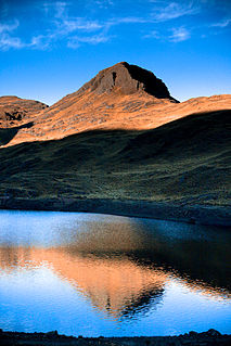
Warawara, often spelled Wara Wara, is a lake in the Tunari National Park in Bolivia. It is located in the Cochabamba Department, Chapare Province, Sacaba Municipality. Warawara lies north east of the city Cochabamba and north of Alalay Lake. The lake is situated 4,105 metres (13,468 ft) high. It is 0.8 km long and 0.5 km at its widest point.
Puma Apachita is a mountain in the Tunari mountain range of the Bolivian Andes, about 4,920 m (16,142 ft) high. It is situated in the Cochabamba Department, Quillacollo Province, Quillacollo Municipality, northwest of Cochabamba. Puma Apachita lies southeast of Jatun Q'asa.
Wayna Tunari is a mountain in the Tunari mountain range of the Bolivian Andes which reaches a height of approximately 4,800 m (15,748 ft). It is situated in the Cochabamba Department, Ayopaya Province, Morochata Municipality, and in the Quillacollo Province, Vinto Municipality. It lies northwest of Tunari.
Wari Warini is a mountain in the Bolivian Andes, about 4,832 m (15,853 ft) high. It is situated in the Cochabamba Department, Quillacollo Province, Quillacollo Municipality, east of the Ipilla Mayu.
Uma Jalanta is a mountain in the Cordillera Real in the Andes of Bolivia, about 5,723 metres (18,776 ft) high. It is located in the La Paz Department, Larecaja Province, Sorata Municipality. It lies south-east of the mountains Janq'u Uma and Janq'u Piti, near the mountain Misk'i T'ant'a.
Wiluyu Janq'u Uma or Wiluyu is a mountain in the Cordillera Real in the Andes of Bolivia, about 5,540 metres (18,176 ft) high. It is located in the La Paz Department, Larecaja Province, Sorata Municipality. It lies northwest of the mountain Yapuchañani, northeast of Misk'i T'ant'a and Uma Jalanta and east of Illampu.
Jukumarini is a 4,272-metre-high (14,016 ft) mountain in the Bolivian Andes. It is situated in the La Paz Department, Murillo Province, Palca Municipality, near the border with the Sud Yungas Province, Irupana Municipality. Jukumarini lies southeast of Illimani, northeast of the village of Jukumarini (Jucumarini). The peak northeast of it is named K'usill Willk'i.

Layqa Qullu is a 6,166-metre-high (20,230 ft) peak in the Cordillera Real in the Andes of Bolivia. It is one of the highest peaks in the Illimani massif. It is situated in the La Paz Department, Murillo Province, Palca Municipality, and in the Sud Yungas Province, Irupana Municipality. Layqa Qullu lies south-east of the highest point of the massif, north-west of Link'u Link'u and Silla Pata.
Jukumarini is a 4,552-metre-high (14,934 ft) mountain in the Andes of Bolivia. It is situated in the La Paz Department, Larecaja Province, Sorata Municipality. Jukumarini lies north of the main range of the Cordillera Real, southwest of the mountain Ch'uch'u and west of Ch'uch'u Apachita.
Mullu Q'awa is an archaeological site in Peru on a mountain of that name. It is located in the Cusco Region, Espinar Province, Alto Pichigua District. It lies near the village of Mullu Q'awa (Molloccahua, Molloqhawa). It is situated on top of the mountain at a height of about 4,000 m (13,000 ft).

Chuqi Quta is a mountain in the Andes of Peru, about 5,200 metres (17,060 ft) high. It is located in the Puno Region, El Collao Province, Santa Rosa District. It lies southwest of Jisk'a Mawruma.
Jukumarini is a 3,662-metre-high (12,014 ft) mountain in the Bolivian Andes. It is located in the La Paz Department, Loayza Province, Luribay Municipality.
Q'ara Apachita is a 4,639 m (15,220 ft) mountain in the Bolivian Andes. It is located in the Cochabamba Department, Chapare Province, Villa Tunari Municipality.
Pichaqani is a 4,240-metre-high (13,910 ft) mountain in the Bolivian Andes. It is located in the Cochabamba Department, Quillacollo Province, Vinto Municipality. Pichaqani lies southwest of Tunari and southeast of Phullu Punchu.
Qiñwani is a mountain in the Bolivian Andes which reaches a height of approximately 4,360 m (14,300 ft). It is located in the Cochabamba Department, Quillacollo Province, on the border of the Sipe Sipe Municipality and the Vinto Municipality. Qiñwani lies northwest of Yana Qaqa.
