| Julcán | |
|---|---|
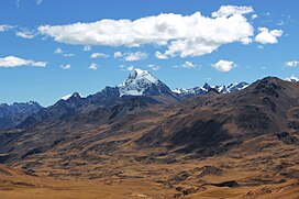 Huacshash with Julcán and Socojirca in the foreground | |
| Highest point | |
| Elevation | 4,900 m (16,100 ft) [1] |
| Coordinates | 10°26′25″S76°57′59″W / 10.44028°S 76.96639°W |
| Geography | |
 Julcán Peru | |
| Location | Peru, Lima Region, Cajatambo Province |
| Parent range | Andes, Huayhuash |
Julcán [1] (possibly from Quechua qullqa, deposit, storehouse, -n a suffix) [2] is a 4,900-metre-high (16,076 ft) mountain in the Huayhuash mountain range in the Andes of Peru. It is located in the Lima Region, Cajatambo Province, Cajatambo District. [3] Julcán lies on a sub-range west of the main range, southwest of Mitopunta and southeast of Huacshash. It is situated north of the Pumarinri valley. [1] [3]