Jungnang District

Last updated
Jungnang
중랑구
중랑구 · 中浪區
Jungang Line and Gyeongchun Line.JPG
Flag of Jungnang, Seoul.svg
Seoul Jungnang-gu.svg
Location of Jungnang-gu in Seoul
Coordinates: 37°36′23″N127°05′33″E / 37.6064°N 127.0926°E / 37.6064; 127.0926 Coordinates: 37°36′23″N127°05′33″E / 37.6064°N 127.0926°E / 37.6064; 127.0926
CountrySouth Korea
Region Sudogwon
Special City Seoul
Administrative dong20
Government
  MayorRyu Gyeong-gi
Area
  Total18.50 km2 (7.14 sq mi)
Population
 (2010 [1] )
  Total403,105
  Density22,000/km2 (56,000/sq mi)
Time zone UTC+9 (Korea Standard Time)
Postal code
02000~02399
Area code02-400~
Website Jungnang-gu official website

Jungnang District (Jungnang-gu) is one of the 25 gu, or districts, of Seoul, South Korea. It is located on the north side of the Han River. [2]

Contents

It is characterized by a typical residential area with many natural green areas such as Yongma, Mangwoo, and Bonghwasan Mountain. It is also a transportation hub in northeastern Seoul as a gateway to Gyeonggi and Gangwon regions. [3]

History

In the current Jungnang-gu, various relics from the Paleolithic and Bronze Age were excavated in Bonghwasan Mountain and Yongmasan Mountain, which are triangular points centered on Mangusan Mountain, and the history of the Jungnang area dates back to the Paleolithic period of the late 30,000 BC. In particular, traces of Saturn remained in the area from Bongsudae in Sangbong-dong to Myeonmok-dong until the 1960s, indicating that the Jungnang area was a city-state during the late Bronze Age and early Iron Age.During the Three Kingdoms Period, it served as a bridgehead for securing the Hangang River basin in Baekje, and after the Unified Silla Period, it became Yangjumok when 12 trees were installed nationwide in 983 of the early Goryeo Dynasty. Among the maps of Hansung Ranch, written by Heo Mok in 1663, Jinheonmajeongdo Island shows that the Han River is in the background of Bulamsan Mountain, Achasan Mountain in the north, and Jungnangcheon Stream and parts of Cheonggyecheon Stream and Sinchon in the east are not clear, but Jungnang-gu and Jungnang-gu are now. On May 26, 1895, the country was reorganized into 23bu 336-gun by Imperial Decree No. 101 and on August 6 of the following year, the 23bu system was abolished, and the country was divided into 13 degrees, and Yangju was separated from Hansung-bu and belonged to Gyeonggi-do as Yangju-gun. On December 29, 1913, the Jungnang area was part of Guri-myeon (currently Sangbong, Junghwa, Muk, Mangwoo, and Sinnae-dong) in Yangju-gun, Gyeonggi-do, and Ttukdo-myeon (currently Myeonmok-dong, Junggok-dong) in Goyang-gun was incorporated into Seoul on August 15, 1949, and on January 1963, Mangnae-ri in Yangjeong-myeon was reunited. On July 1, 1980, Muk-dong was divided into Muk 1-dong and Mangwoo 2-dong into Mangwoo 2-dong, and on January 1, 1988, five districts in Jungnang, Nowon, Seocho, Yangcheon, and Songpa were expanded, and Jungnang-gu was separated and newly established from Dongdaemun-gu.


On January 1, 2008, to improve administrative inefficiency and expand the culture and welfare space of residents, Myeonmok 1-dong and Myeonmok 6-dong were merged into Myeonmokbon-dong, Myeonmok 3-dong and Myeonmok 8-dong into Myeonmok 3-dong, Junghwa 2-dong and Junghwa 3-dong, and Mangwoo 2-dong were merged into Mangwoobon-dong. [4]

Administrative divisions

Administrative divisions 01-07-jungnang-en.svg
Administrative divisions

Transportation

Railroad

(Dongdaemun-gu) ← JungnangSangbongManguYangwon → (Guri)
SangbongManguSinnae → (Guri)
(Nowon-gu) ← BonghwasanSinnae
(Nowon-gu) ← MeokgolJunghwaSangbongMyeonmokSagajeongYongmasan → (Gwangjin-gu)

Sister cities

See also

Related Research Articles

South Korea is made up of 17 first-tier administrative divisions: 6 metropolitan cities, 1 special city, 1 special self-governing city, and 9 provinces, including one special self-governing province. These are further subdivided into a variety of smaller entities, including cities, counties, districts, towns, townships, neighborhoods and villages.

<span class="mw-page-title-main">Guri</span> Municipal City in Gyeonggi Province, South Korea

Guri (Korean pronunciation: [ˈku.ɾi], lit. Nine Villages Town is a city in Gyeonggi Province, South Korea. It is located immediately to the east of Seoul, in the heart of the Capital Metropolitan Area.

<span class="mw-page-title-main">Namyangju</span> City in Gyeonggi Province, South Korea

Namyangju is a city in Gyeonggi Province, South Korea. To the east is Gapyeong County, to the west is Guri City, and to the north is Pocheon City. Namyangju-si was originally a southern part of Yangju-gun, but was separated into Namyangju-gun in April 1980. In 1995, Migeum-si and Namyangju-gun were merged to form an urban and rural complex. The city hall is located in Geumgok-dong and Dasan-dong, and the administrative districts are 6-eup, 3-myeon, and 7-dong.

<span class="mw-page-title-main">Pocheon</span> Municipal City in Gyeonggi Province, South Korea

Pocheon (Korean pronunciation: [pʰo.tsʰʌn]) is an inland city in the far northeastern region of Gyeonggi province in South Korea. It covers 826.48 km (513.55 mi)2 with a population of 160,176 people, according to the 2008 census. Pocheon lies between Seoul and the mountainous northwestern areas of Gangwon province. The city borders Yeoncheon county, with the cities of Dongducheon and Yangju to the west, along with Uijeongbu, and Namyangju of Gyeonggi province to the south. It also borders Hwacheon county of Gangwon province on its eastern border and Cheorwon is to the north. Alongside the adjoining Gapyeong, Pocheon consists of the highest mountainous areas in Gyeonggi province. The current city of Pocheon was created after Pocheon-hyeon and Yeongpyeong counties were merged. The north part of the city used to be part of Yeongpyeong county while the south used to be part of Pocheon-hyeon.

<span class="mw-page-title-main">Seoul Buses</span> Buses in Seoul

Seoul Buses are public transit buses operated by the Seoul Metropolitan Government and/or private bus operators.

<span class="mw-page-title-main">Nowon District</span> Autonomous District in Sudogwon, South Korea

Nowon District (Nowon-gu) is a residential district of Seoul, South Korea, located in the most northeastern part of the metropolitan city. It has the highest population density in Seoul, with 619,509 people living in the area of 35.44 km².

<span class="mw-page-title-main">Seongdong District</span> Autonomous District in Sudogwon, South Korea

Seongdong District (Seongdong-gu) is one of the 25 gu which make up the city of Seoul, South Korea. It is situated on the north bank of the Han River. It is divided into 20 dong (neighbourhoods).

<span class="mw-page-title-main">Seongbuk District</span> Autonomous District in Sudogwon, South Korea

Seongbuk District (Seongbuk-gu) is one of the 25 gu which make up the city of Seoul, South Korea. It is located in the mid-north part of the city. The current Mayor is Kim Young-bae (김영배), who has been mayor since July 1, 2010. Seongbuk-gu was established under Presidential Decree No. 159 on August 13, 1949, and was promoted to a autonomous district by implementing a Gu-level local government on May 1, 1988.

<span class="mw-page-title-main">Dobong District</span> Autonomous District in Sudogwon, South Korea

Dobong District is one of the 25 districts of Seoul, South Korea.

<span class="mw-page-title-main">Dongdaemun District</span> Autonomous District in Sudogwon, South Korea

Dongdaemun District is one of the 25 districts of Seoul, South Korea.

<span class="mw-page-title-main">Gwangjin District</span> Autonomous District in Sudogwon, South Korea

Gwangjin District (Gwangjin-gu) is one of the 25 wards (gu) of Seoul, South Korea. It is located on the north bank of the Han River, to the eastern end of Seoul. It was created from neighboring Seongdong District in 1995.

<span class="mw-page-title-main">Bangbae-dong</span> Place in South Korea

Bangbae-dong is a dong, or neighbourhood of the greater Gangnam area Seocho-gu district of the South Korean city of Seoul. Bangbae-dong is divided into 5 different dongs which are Bangbaebon-dong, Bangbae 1-dong, 2-dong, 3-dong and 4-dong. The origin of Bangbae-dong is derived from the name Bangbae, meaning "dong-ri with my back to Mt. Myeon-ri," which rises on the border between Gwanak-gu and Seocho-gu. Bangbae-dong was Bangbae-ri, Sangbuk-myeon, Gwacheon-gun, Gyeonggi-do until the end of the Joseon Dynasty, but became Bangbae-ri, Sindong-myeon, Siheung-gun, Gyeonggi-do in 1914 when the area was confirmed during the Japanese colonial period. It was incorporated into the Seoul Metropolitan Government following the expansion of the Seoul Metropolitan Government's zone in 1963, and became Bangbae-dong to this day. The location is Dong at the western end of Seocho-gu, and it is an area from the intersection of the road from Seoul to Gwacheon City and the southern circulation road to Umyeon Mountain.

<span class="mw-page-title-main">Samseong-dong</span> Place in South Korea

Samseong-Dong is an affluent neighborhood or ward of Gangnam-gu in Seoul, South Korea.

Myeongil-dong is a dong, neighbourhood of Gangdong-gu in Seoul, South Korea.

<span class="mw-page-title-main">Junghwa-dong</span> Place in South Korea

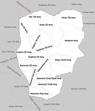
Junghwa-dong is a dong, neighbourhood of Jungnang-gu in Seoul, South Korea.

<span class="mw-page-title-main">Mangu-dong</span> Place in South Korea

Mangu-dong is a dong, neighbourhood of Jungnang-gu in Seoul, South Korea.

<span class="mw-page-title-main">Muk-dong</span> Place in South Korea

Muk-dong is a dong, neighbourhood of Jungnang-gu in Seoul, South Korea.

Sangbong-dong is a dong, a neighbourhood of Jungnang-gu in Seoul, South Korea.

Jugyo-dong is a legal dong, or neighbourhood of the Jung-gu district in Seoul, South Korea. It is governed by its administrative dong, Euljiro 3, 4, 5ga-dong.

<span class="mw-page-title-main">Dongbu Expressway</span> Expressway in Seoul, South Korea

Dongbu Expressway (Korean: 동부간선도로) is an urban expressway located in Gyeonggi and Seoul, South Korea. With a total length of 32.5 km (20.2 mi), this expressway starts from the Bokjeong Interchange in Songpa District, Seoul to Sangchon Interchange in Uijeongbu City, Gyeonggi.

References

  1. Korean Statistical Information Service (Korean) > Population and Household > Census Result (2010) > Population by Administrative district, Sex and Age / Alien by Administrative district and Sex Archived 2013-08-26 at the Wayback Machine , Retrieved 2010-06-02.
  2. "중랑구 (Jungnang-gu 中浪區)" (in Korean). Doosan Encyclopedia. Retrieved 2008-04-17.[ permanent dead link ]
  3. "기본현황". www.jungnang.go.kr. Retrieved 2022-09-26.
  4. "연혁". www.jungnang.go.kr. Retrieved 2022-09-26.