
Nordland is one of the three northernmost counties in Norway in the Northern Norway region, bordering Troms in the north, Trøndelag in the south, Norrbotten County in Sweden to the east, Västerbotten County to the south-east, and the Atlantic Ocean to the west. The county was formerly known as Nordlandene amt. The county administration is in the town of Bodø. The remote Arctic island of Jan Mayen has been administered from Nordland since 1995. In the southern part of the county is Vega, listed on the UNESCO World Heritage Site list.

Saltdal is a municipality in Nordland county, Norway. It is part of the traditional district of Salten. The administrative centre of the municipality is the village of Rognan. Other villages in Saltdal include Røkland, Lønsdal, Langset, and Saksenvika.

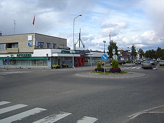
Valkeakoski is a town and municipality in Finland. It is located 35 kilometres (22 mi) south of Tampere, 45 km (28 mi) north of Hämeenlinna and 150 km (93 mi) north of Helsinki in the Pirkanmaa region. The municipality has a population of 20,788 (31 August 2024) and covers an area of 372.03 square kilometres (143.64 sq mi) of which 100.06 km2 (38.63 sq mi) is water. The population density is 76.41 inhabitants per square kilometre (197.9/sq mi).

Inari is Finland's largest municipality by area, with four official languages, more than any other in the country. Its major sources of income are tourism, service industry, and cold climate testing. With the Siida museum in the village of Inari, it is a center of Sámi culture, widely known as the "capital of Sámi culture".
Sodankylä is a municipality of Finland. It is located in the region of Lapland, and lies at the northern end of Highway 5 (E63) and along Highway 4 (E75). The Kitinen River flows near the center of Sodankylä. Its neighbouring municipalities are Inari, Kemijärvi, Kittilä, Pelkosenniemi, Rovaniemi, and Savukoski. The municipality has two official languages: Finnish and Northern Sami.

Rognan is a village and the administrative centre of Saltdal Municipality in Nordland county, Norway. The village is located at the head of the Saltdal Fjord. It is located about 15 kilometres (9.3 mi) north of the village of Røkland.
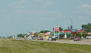
Martensville is a city located in Saskatchewan, Canada, just 8 kilometres (5.0 mi) north of Saskatoon, 10 kilometres (6.2 mi) west of the city of Warman and 14 kilometres (8.7 mi) southwest of Clarkboro Ferry which crosses the South Saskatchewan River. It is a bedroom community of Saskatoon. It is surrounded by the Rural Municipality of Corman Park No. 344. The community is served by the Saskatoon/Richter Field Aerodrome located immediately west of the city across Highway 12, as well as by Saskatoon's John G. Diefenbaker International Airport, only a few miles to the south.
Skutvika or Skutvik is a small village in Hamarøy Municipality in Nordland county, Norway. The village is situated at the southwestern extreme of the Hamarøya peninsula, about 90 kilometres (56 mi) north of the town of Bodø, 95 kilometres (59 mi) southwest of the town of Narvik, and 40 kilometres (25 mi) south of the town of Svolvær. To the west and south of Skutvik is the Økssundet, a sound connecting the Sagfjorden and Vestfjorden. The landscape in the immediate vicinity of the village is dominated by hills, while further north a row of mountains rises up to 950 metres (3,120 ft) above sea level.

Junkerdal National Park is a national park in Saltdal Municipality and Fauske Municipality in Nordland county, Norway, along its border with Sweden. The 682-square-kilometre (263 sq mi) park opened in 2004. It borders the Junkerdalsura nature reserve.

Balvatnet (Norwegian) or Bállávrre (Lule Sami) is a lake that lies in Saltdal Municipality in Nordland county, Norway. The 41.46-square-kilometre (16.01 sq mi) lake is located on the border of Junkerdal National Park, about 2 kilometres (1.2 mi) west of the border with Sweden. The lake is regulated for hydroelectric power at the Daja Hydroelectric Power Station 16 kilometres (9.9 mi) to the north in Sulitjelma.
Fisklausvatnet (Norwegian) or Guoledisjávrre (Lule Sami) is a lake that lies in Saltdal Municipality in Nordland county, Norway. The 2.28-square-kilometre (0.88 sq mi) lake is located inside Junkerdal National Park, about 2 kilometres (1.2 mi) south of the border with Fauske Municipality.
Kjelvatnet (Norwegian) or Giebbnejávrre (Lule Sami) is a lake in Fauske Municipality in Nordland county, Norway. The 3.85-square-kilometre (1.49 sq mi) lake lies about 7 kilometres (4.3 mi) south of the village of Sulitjelma near the border with Junkerdal National Park. Water flows into the lake from the large lake Balvatnet and it flows out of the lake to the north along the Balmi River to the lake Langvatnet.

Røkland (Norwegian) or Rævkka (Lule Sami) is a village in Saltdal Municipality in Nordland county, Norway. The village is located along the Saltdalselva river about 15 kilometres (9.3 mi) south of the municipal centre of Rognan. European route E06 and the Nordland Line both pass through the village. Røkland Station is a train station along the Nordland Line. Øvre Saltdal Church is located in Røkland.
Lønsdal (Norwegian) or Luonosvágge (Lule Sami) is a village in Saltdal Municipality in Nordland county, Norway. The village is located in the Lønsdal valley, along the Lønselva river. The European route E06 highway and the Nordland Line railway both pass through the village. The village also has a train station on the Nordland Line, about halfway between Dunderland Station and Røkland Station.

The E1 European long-distance path, or just E1 path, is one of the European long-distance paths designated by the European Ramblers' Association. It has a total length of some 7,000 kilometres (4,300 mi). It begins in Norway at the North Cape in Nordkapp Municipality, it progresses to the south and crosses the Kattegat between Sweden and Denmark by ferry. It passes through Denmark, Germany, and Switzerland to finish at Capo Passero, Italy. This path was extended southwards to Sicily, in Italy, in 2018.

Milde is a neighbourhood in the city of Bergen in Vestland county, Norway.

Årstein (Norwegian) or Árjogeargi or Orrageargi (Northern Sami) is the administrative centre of Gratangen Municipality in Troms county, Norway. The village is located on the north side of the Gratangsfjorden at the narrowest point along the fjord. The Årstein Bridge crosses the fjord here. The village is located about 6 kilometres (3.7 mi) northwest of the village of Fjordbotn and about 15 kilometres (9.3 mi) from the village of Hilleshamn.
Langset (Norwegian) or Laŋsæhtta (Lule Sami) is a village and basic statistical unit in the Nedre Saltdal area of Saltdal Municipality in Nordland county, Norway. The area is located north of Rognan and Saksenvika and south of Setså on the east side of Saltdal Fjord. The European route E6 highway and the Nordland Line railway both pass through the area.

Skjerstad is a former municipality in Nordland county, Norway. The 465-square-kilometre (180 sq mi) municipality existed from 1838 until its dissolution in 2005. The area is now part of Bodø Municipality in the traditional district of Salten. The administrative centre was the village of Misvær. Another village in the municipality was the village of Skjerstad where Skjerstad Church was located. The municipality generally encompassed the area around the Misværfjorden, although it originally was much larger, also including the entire present-day Fauske Municipality.
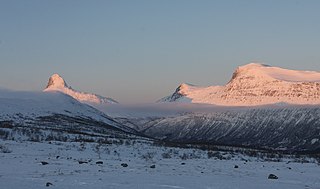
Junkerdalen or Juŋŋkárvuobme (Lule Sami) is a valley in Saltdal Municipality in Nordland county. It is a side valley to the main Saltdalen valley. The Junkerdalen valley begins at the village of Storjord from where it stretches in a south-easterly direction towards Graddis and the national border with Sweden. The beginning of Junkerdalen is a narrow gorge called Junkerdalsura, where Junkerdalselva flows into waterfalls and rapids before it joins with Lønselva and after this, it is called Saltdalselva. The side valleys Tjårrisdalen and Skaitidalen go out from Junkerdalen in a northerly direction. Up in the valley, Graddiselva and Skaitielva flow together, and from here the river is called Junkerdalselva. Between Tjårrisdalen and Junkerdalsura lies the village of Junkerdal.


