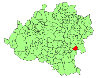
Kürkükler, Alaplı

Last updated
Kürkükler
Village
Country Flag of Turkey.svg  Turkey
Province Zonguldak Province
District Alaplı
Time zone EET (UTC+2)
  Summer (DST) EEST (UTC+3)

Kürkükler is a village in Alaplı District, Zonguldak Province, Turkey. [1]

Alaplı Place in Zonguldak, Turkey

Alaplı is a town and district of Zonguldak Province in the Black Sea region of Turkey. It is the westernmost town in Zonguldak Province and is located about 15 km (9.3 mi) south of Karadeniz Ereğli. It has 2 municipalities, one is the centre and the other is named as "Gümeli". The mayor is Nuri Tekin (CHP).

Zonguldak Province Municipality in Turkey

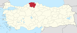
Zonguldak Province is a province along the western Black Sea coast region of Turkey. The province is 3.481 km2 in size and has a population of 619,703. Its adjacent provinces are Düzce to the southwest, Bolu to the south, Karabük to the southeast, and Bartın to the east. The capital is Zonguldak.

Turkey Republic in Western Asia

Turkey, officially the Republic of Turkey, is a transcontinental country located mainly in Western Asia, with a smaller portion on the Balkan Peninsula in Southeast Europe. East Thrace, located in Europe, is separated from Anatolia by the Sea of Marmara, the Bosphorous strait and the Dardanelles. Turkey is bordered by Greece and Bulgaria to its northwest; Georgia to its northeast; Armenia, the Azerbaijani exclave of Nakhchivan and Iran to the east; and Iraq and Syria to the south. Istanbul is the largest city, but more central Ankara is the capital. Approximately 70 to 80 per cent of the country's citizens identify as Turkish. Kurds are the largest minority; the size of the Kurdish population is a subject of dispute with estimates placing the figure at anywhere from 12 to 25 per cent of the population.

Related Research Articles

Geography of Armenia

Armenia is a landlocked country in the Transcaucasia region, between the Black and Caspian Seas, bordered on the north and east by Georgia and Azerbaijan and on the south and west by Iran and Turkey.

Muş Province Province of Turkey in Central East Anatolia

Muş Province, is a province in eastern Turkey. It is 8,196 km2 in area and has a population of 406,886 according to a 2010 estimate, down from 453,654 in 2000. The provincial capital is the city of Muş. Another town in Muş province, Malazgirt (Manzikert), is famous for the Battle of Manzikert of 1071. The majority of the province's population is Kurdish.

Thracian Sea Northernmost part of the Aegean sea

The Thracian Sea is a sea that is part of the Aegean Sea and forms the northernmost point of the sea. Regions surrounding the sea are Macedonia and Thrace as well as northwestern Turkey. The entire stretch of the sea lies north of the 40th parallel. The length from east to west is from 23°E to about 25.8°E or from the Strymonian Gulf east to the northernmost part of the Gallipoli peninsula and the width from north to south is about 40.25°N to 41°N or from the Dardanelles north to the boundary between the Xanthi and the Rhodope regional units. Islands includes Thasos and Samothrace in Greece and Gökçeada and Bozcaada in Turkey. The bays and gulfs includes the Ierissian Gulf to the southwest, the Strymonian Gulf where the Strymon River empties, the Kavala Gulf and the Saros Gulf in Turkey. Rivers emptying into this portion of the gulf include the Nestos and the Evros/Meriç. The famous thermal springs are Loutra Eleftheron in Kavala.

Torlengua Place in Castile and León, Spain

Torlengua is a municipality located in the province of Soria, Castile and León, Spain. According to the 2004 census (INE), the municipality has a population of 97 inhabitants.

Petricani Commune in Neamț County, Romania

Petricani is a commune in Neamț County, Romania. It is composed of four villages: Boiștea, Petricani, Târpești and Țolici.

Öğürlü is a village in the Vezirköprü, Samsun Province, Turkey.

Karkucak is a village in the Vezirköprü, Samsun Province, Turkey.

Yağınözü is a village in the Vezirköprü, Samsun Province, Turkey.

Sırbaşmak is a village in the Vezirköprü, Samsun Province, Turkey.

Sarıömer, Kastamonu Village in Kastamonu Province, Turkey

Sarıömer is a village in the District of Kastamonu, Kastamonu Province, Turkey.

Kurtgömeç, Kastamonu Village in Kastamonu Province, Turkey

Kurtgömeç is a village in the District of Kastamonu, Kastamonu Province, Turkey.

Istanbul (electoral districts) electoral districts of the Grand National Assembly of Turkey

Istanbul is a Turkish province divided into three electoral districts of the Grand National Assembly of Turkey. It elects eighty-five members of parliament (deputies) to represent the province of the same name for a four-year term by the D'Hondt method, a party-list proportional representation system.

Alaplıkocaali is a village in Alaplı District, Zonguldak Province, Turkey.

Durhanlı is a village in Alaplı District, Zonguldak Province, Turkey.

Küçükkaymaz is a village in Alaplı District, Zonguldak Province, Turkey.

Sofullu is a village in Alaplı District, Zonguldak Province, Turkey.

Başlarkadı is a village in Devrek District, Zonguldak Province, Turkey.

Dokuzkat is a village in the District of Kastamonu, Kastamonu Province, Turkey.

Örenyeri is a village in the District of Kastamonu, Kastamonu Province, Turkey.

Ortaboğaz is a village in the District of Kastamonu, Kastamonu Province, Turkey.

References

  1. "Koyler" (in Turkish). Yerelnet.org. Retrieved 1 November 2015.

Coordinates: 41°10′N31°27′E / 41.167°N 31.450°E / 41.167; 31.450

Geographic coordinate system Coordinate system

A geographic coordinate system is a coordinate system that enables every location on Earth to be specified by a set of numbers, letters or symbols. The coordinates are often chosen such that one of the numbers represents a vertical position and two or three of the numbers represent a horizontal position; alternatively, a geographic position may be expressed in a combined three-dimensional Cartesian vector. A common choice of coordinates is latitude, longitude and elevation. To specify a location on a plane requires a map projection.