Adamowo is a village in the administrative district of Gmina Jabłonowo Pomorskie, within Brodnica County, Kuyavian-Pomeranian Voivodeship, in north-central Poland. It lies 4 kilometres (2 mi) north of Jabłonowo Pomorskie, 25 km (16 mi) north-west of Brodnica, and 58 km (36 mi) north-east of Toruń.

Krasny Las is a village in the administrative district of Gmina Supraśl, within Białystok County, Podlaskie Voivodeship, in north-eastern Poland. It lies approximately 5 kilometres (3 mi) south of Supraśl and 14 km (9 mi) north-east of the regional capital Białystok.
Stare Grabowo is a village in the administrative district of Gmina Zawady, within Białystok County, Podlaskie Voivodeship, in north-eastern Poland.
Nowe Zacieczki is a village in the administrative district of Gmina Szczuczyn, within Grajewo County, Podlaskie Voivodeship, in north-eastern Poland. It lies approximately 6 kilometres (4 mi) north of Szczuczyn, 12 km (7 mi) west of Grajewo, and 82 km (51 mi) north-west of the regional capital Białystok.
Zamoście-Wieś is a village in the administrative district of Gmina Strzelce Wielkie, within Pajęczno County, Łódź Voivodeship, in central Poland. It lies approximately 3 kilometres (2 mi) east of Strzelce Wielkie, 13 km (8 mi) east of Pajęczno, and 75 km (47 mi) south of the regional capital Łódź.
Kuźnica Ługowska is a village in the administrative district of Gmina Osjaków, within Wieluń County, Łódź Voivodeship, in central Poland. It lies approximately 4 kilometres (2 mi) east of Osjaków, 20 km (12 mi) east of Wieluń, and 72 km (45 mi) south-west of the regional capital Łódź.
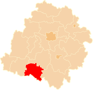
Owczary is a village in the administrative district of Gmina Zielonki, within Kraków County, Lesser Poland Voivodeship, in southern Poland. It lies approximately 13 km (8 mi) north of the regional capital Kraków.
Zalesie is a village in the administrative district of Gmina Zamość, within Zamość County, Lublin Voivodeship, in eastern Poland.
Starzechowice is a village in the administrative district of Gmina Fałków, within Końskie County, Świętokrzyskie Voivodeship, in south-central Poland. It lies approximately 5 kilometres (3 mi) north of Fałków, 24 km (15 mi) west of Końskie, and 50 km (31 mi) north-west of the regional capital Kielce.
Kawęczyn is a village in the administrative district of Gmina Konstancin-Jeziorna, within Piaseczno County, Masovian Voivodeship, in east-central Poland.
Niedarczów Górny-Kolonia is a village in the administrative district of Gmina Kazanów, within Zwoleń County, Masovian Voivodeship, in east-central Poland.
Włodzimirów is a village in the administrative district of Gmina Kazimierz Biskupi, within Konin County, Greater Poland Voivodeship, in west-central Poland. It lies approximately 5 kilometres (3 mi) south-east of Kazimierz Biskupi, 8 km (5 mi) north-west of Konin, and 90 km (56 mi) east of the regional capital Poznań.
Przybyłów is a village in the administrative district of Gmina Koło, within Koło County, Greater Poland Voivodeship, in west-central Poland. It lies approximately 7 kilometres (4 mi) south-east of Koło and 126 km (78 mi) east of the regional capital Poznań.
Siedmiórki is a settlement in the administrative district of Gmina Wijewo, within Leszno County, Greater Poland Voivodeship, in west-central Poland. It lies approximately 3 kilometres (2 mi) south-west of Wijewo, 28 km (17 mi) west of Leszno, and 75 km (47 mi) south-west of the regional capital Poznań.
Słupia is a village in the administrative district of Gmina Debrzno, within Człuchów County, Pomeranian Voivodeship, in northern Poland. It lies approximately 7 kilometres (4 mi) north-east of Debrzno, 10 km (6 mi) south-west of Człuchów, and 125 km (78 mi) south-west of the regional capital Gdańsk.
Łaguszewo is a village in the administrative district of Gmina Trąbki Wielkie, within Gdańsk County, Pomeranian Voivodeship, in northern Poland. It lies approximately 4 kilometres (2 mi) east of Trąbki Wielkie, 11 km (7 mi) south of Pruszcz Gdański, and 22 km (14 mi) south of the regional capital Gdańsk.
Pilwa is a village in the administrative district of Gmina Bartoszyce, within Bartoszyce County, Warmian-Masurian Voivodeship, in northern Poland, close to the border with the Kaliningrad Oblast of Russia.
Bądle is a village in the administrative district of Gmina Górowo Iławeckie, within Bartoszyce County, Warmian-Masurian Voivodeship, in northern Poland, close to the border with the Kaliningrad Oblast of Russia.
Krytno is a village in the administrative district of Gmina Polanów, within Koszalin County, West Pomeranian Voivodeship, in north-western Poland. It lies approximately 14 kilometres (9 mi) north-west of Polanów, 24 km (15 mi) east of Koszalin, and 154 km (96 mi) north-east of the regional capital Szczecin.
Zakavoliai is a village in Varėna district municipality, in Alytus County, in southeastern Lithuania. According to the 2001 census, the village has a population of 10 people.