Atmospheric pressure, also known as air pressure or barometric pressure, is the pressure within the atmosphere of Earth. The standard atmosphere is a unit of pressure defined as 101,325 Pa (1,013.25 hPa), which is equivalent to 1,013.25 millibars, 760 mm Hg, 29.9212 inches Hg, or 14.696 psi. The atm unit is roughly equivalent to the mean sea-level atmospheric pressure on Earth; that is, the Earth's atmospheric pressure at sea level is approximately 1 atm.

The horizon is the apparent curve that separates the surface of a celestial body from its sky when viewed from the perspective of an observer on or near the surface of the relevant body. This curve divides all viewing directions based on whether it intersects the relevant body's surface or not.

The geography of the European Netherlands is unusual in that much of its land has been reclaimed from the sea and is below sea level, protected by dikes. It is a small country with a total area of 41,545 km2 (16,041 sq mi) and ranked 131st. With a population of 17.4 million and density of 521/km2 (1,350/sq mi) makes it the second most densely populated member of the European Union after Malta, and the 12th most densely populated country in the world, behind only three countries with a population over 16 million. Consequently, the Netherlands is highly urbanized.
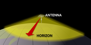
Line-of-sight propagation is a characteristic of electromagnetic radiation or acoustic wave propagation which means waves can only travel in a direct visual path from the source to the receiver without obstacles. Electromagnetic transmission includes light emissions traveling in a straight line. The rays or waves may be diffracted, refracted, reflected, or absorbed by the atmosphere and obstructions with material and generally cannot travel over the horizon or behind obstacles.

Regolith is a blanket of unconsolidated, loose, heterogeneous superficial deposits covering solid rock. It includes dust, broken rocks, and other related materials and is present on Earth, the Moon, Mars, some asteroids, and other terrestrial planets and moons.
Wind shear, sometimes referred to as wind gradient, is a difference in wind speed and/or direction over a relatively short distance in the atmosphere. Atmospheric wind shear is normally described as either vertical or horizontal wind shear. Vertical wind shear is a change in wind speed or direction with a change in altitude. Horizontal wind shear is a change in wind speed with a change in lateral position for a given altitude.
In common usage, wind gradient, more specifically wind speed gradient or wind velocity gradient, or alternatively shear wind, is the vertical component of the gradient of the mean horizontal wind speed in the lower atmosphere. It is the rate of increase of wind strength with unit increase in height above ground level. In metric units, it is often measured in units of meters per second of speed, per kilometer of height (m/s/km), which reduces to the standard unit of shear rate, inverse seconds (s−1).
METAR is a format for reporting weather information. A METAR weather report is predominantly used by aircraft pilots, and by meteorologists, who use aggregated METAR information to assist in weather forecasting.

The Gerbrandy Tower is a tower in IJsselstein, the Netherlands. It is also known as Lopik tower after the nearby town. It was built in 1961.

Sea surface temperature (SST), or ocean surface temperature, is the ocean temperature close to the surface. The exact meaning of surface varies according to the measurement method used, but it is between 1 millimetre (0.04 in) and 20 metres (70 ft) below the sea surface. Air masses in the Earth's atmosphere are highly modified by sea surface temperatures within a short distance of the shore. Localized areas of heavy snow can form in bands downwind of warm water bodies within an otherwise cold air mass. Warm sea surface temperatures are known to be a cause of tropical cyclogenesis over the Earth's oceans. Tropical cyclones can also cause a cool wake, due to turbulent mixing of the upper 30 metres (100 ft) of the ocean. SST changes diurnally, like the air above it, but to a lesser degree. There is less SST variation on breezy days than on calm days. In addition, ocean currents, such as the Atlantic Multidecadal Oscillation (AMO), can affect SST's on multi-decadal time scales, and a major impact results from the global thermohaline circulation, which affects average SST significantly throughout most of the world's oceans.

In meteorology, the planetary boundary layer (PBL), also known as the atmospheric boundary layer (ABL) or peplosphere, is the lowest part of the atmosphere and its behaviour is directly influenced by its contact with a planetary surface. On Earth it usually responds to changes in surface radiative forcing in an hour or less. In this layer physical quantities such as flow velocity, temperature, and moisture display rapid fluctuations (turbulence) and vertical mixing is strong. Above the PBL is the "free atmosphere", where the wind is approximately geostrophic, while within the PBL the wind is affected by surface drag and turns across the isobars.
A scatterometer or diffusionmeter is a scientific instrument to measure the return of a beam of light or radar waves scattered by diffusion in a medium such as air. Diffusionmeters using visible light are found in airports or along roads to measure horizontal visibility. Radar scatterometers use radio or microwaves to determine the normalized radar cross section of a surface. They are often mounted on weather satellites to find wind speed and direction, and are used in industries to analyze the roughness of surfaces.

Cabauw is a village in the Dutch province of Utrecht. It is part of the municipality of Lopik, and lies about 12 km southwest of IJsselstein. Cabauw consists of a small village centre, and a ribbon of farms along the Lopikerwetering canal, between Zevender and Lopik.

The Royal Dutch Meteorological Institute is the Dutch national weather forecasting service, which has its headquarters in De Bilt, in the province of Utrecht, central Netherlands.

The Saharan Air Layer (SAL) is an extremely hot, dry and sometimes dust-laden layer of the atmosphere that often overlies the cooler, more-humid surface air of the Atlantic Ocean. It carries upwards of 60 million tonnes of dust annually over the ocean and the Americas. This annual phenomenon sometimes cools the ocean and suppresses Atlantic tropical cyclogenesis.
The maximum sustained wind associated with a tropical cyclone is a common indicator of the intensity of the storm. Within a mature tropical cyclone, it is found within the eyewall at a distance defined as the radius of maximum wind, or RMW. Unlike gusts, the value of these winds are determined via their sampling and averaging the sampled results over a period of time. Wind measuring has been standardized globally to reflect the winds at 10 metres (33 ft) above mean sea level, and the maximum sustained wind represents the highest average wind over either a one-minute (US) or ten-minute time span, anywhere within the tropical cyclone. Surface winds are highly variable due to friction between the atmosphere and the Earth's surface, as well as near hills and mountains over land.
Road surface textures are deviations from a planar and smooth surface, affecting the vehicle/tyre interaction. Pavement texture is divided into: microtexture with wavelengths from 0 mm to 0.5 millimetres (0.020 in), macrotexture with wavelengths from 0.5 millimetres (0.020 in) to 50 millimetres (2.0 in) and megatexture with wavelengths from 50 millimetres (2.0 in) to 500 millimetres (20 in).
Flux footprint is an upwind area where the atmospheric flux measured by an instrument is generated. Specifically, the term flux footprint describes an upwind area "seen" by the instruments measuring vertical turbulent fluxes, such that heat, water, gas and momentum transport generated in this area is registered by the instruments. Another frequently used term, fetch, usually refers to the distance from the tower when describing the footprint.

The radar horizon is a critical area of performance for aircraft detection systems that is defined by the distance at which the radar beam rises enough above the Earth's surface to make detection of a target at the lowest level possible. It is associated with the low elevation region of performance, and its geometry depends on terrain, radar height, and signal processing. This is associated with the notions of radar shadow, the clutter zone, and the clear zone.
MELOS is a Japanese rover mission concept under study for an engineering demonstration of precision landing, and to look for possible biosignatures on Mars using a rover. JAXA has not published updates since 2015.

