
The Limpopo River rises in South Africa, and flows generally eastwards through Mozambique to the Indian Ocean. The term Limpopo is derived from Rivombo (Livombo/Lebombo), a group of Tsonga settlers led by Hosi Rivombo who settled in the mountainous vicinity and named the area after their leader. The river is approximately 1,750 kilometres (1,087 mi) long, with a drainage basin 415,000 square kilometres (160,200 sq mi) in size. The mean discharge measured over a year is 170 m3 per second at its mouth. The Limpopo is the second largest river in Africa that drains to the Indian Ocean, after the Zambezi River.

The Orange River also known in isiZulu as isAngqu is a river in Southern Africa. It is the longest river in South Africa. With a total length of 2,432 km (1,511 mi), the Orange River Basin extends from Lesotho into South Africa and Namibia to the north. It rises in the Drakensberg mountains in Lesotho, flowing westwards through South Africa to the Atlantic Ocean. The river forms part of the international borders between South Africa and Lesotho and between South Africa and Namibia, as well as several provincial borders within South Africa. Except for Upington, it does not pass through any major cities. The Orange River plays an important role in the South African economy by providing water for irrigation and hydroelectric power. The river was named the Orange River in honour of the Dutch ruling family, the House of Orange, by the Dutch explorer Robert Jacob Gordon. Other names include simply the word for river, in Khoekhoegowab orthography written as !Garib, which is rendered in Afrikaans as Gariep River with the intrusion of a velar fricative in place of the alveolar click, Groote River or Senqu River, derived from ǂNū "Black".

The Northern Cape is the largest and most sparsely populated province of South Africa. It was created in 1994 when the Cape Province was split up. Its capital is Kimberley. It includes the Kalahari Gemsbok National Park, part of the Kgalagadi Transfrontier Park and an international park shared with Botswana. It also includes the Augrabies Falls and the diamond mining regions in Kimberley and Alexander Bay.
Mswati II, also known as Mswati and Mavuso II, was the king of Eswatini between 1840 and 1865. He was also the eponym of Eswatini. Mswati is considered to be one of the greatest fighting kings of Eswatini. Under his kingship, the territorial boundaries of Eswatini were greatly increased. Mswati was the son of Sobhuza I and Tsandzile Ndwandwe who after ruling as Queen Mother became Queen Regent after the death of her son. After the death of Sobhuza, Mswati inherited an area which extended as far as present day Barberton in the north and included the Nomahasha district in the Portuguese territory of Mozambique. Mswati's military power, initially suppressed by infighting with his brothers Fokoti, Somcuba and Malambule, was increased in the late 1850s and thereafter. When Mswati's armies attacked organized forces of other Bantu tribes or nations, the goal was initially plunder in the form of cattle and captives, rather than incorporation into one political unit. During this period the arrival of Trekboers, in what would become the Transvaal republic, marked the first contact between Swazis and European settlers. Mswati greatly extended the boundaries of the Swazi territory beyond that of the present state with military outposts and royal villages outposts such as Mbhuleni, on the upper Komati River at the foot of the Mkongomo Mountains, south of Badplaas, Mekemeke which is east of the Mbayiyane Mountains, situated east of Mantibovu. The death of Mswati II in August 1865 ended the era of Swazi conquest, territorial expansion and resulted in unification of various people into one nation.
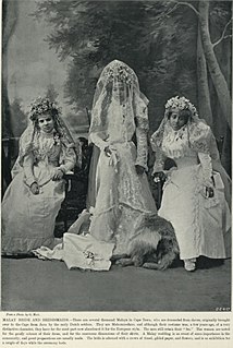
Cape Malays also known as Cape Muslims or Malays, are a Muslim community or ethnic group in South Africa. They are the descendants of enslaved and free Muslims from different parts of the world who lived at the Cape during Dutch and British rule.

The Molopo River is one of the main rivers in Southern Africa. It has a length of approximately 960 kilometres and a catchment area of 367,201 km2 with Botswana, Namibia and South Africa sharing roughly about a third of the basin each.
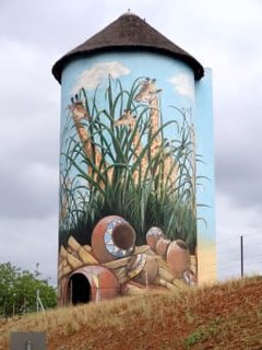
Kaapmuiden(Cape Mouth) is a small farming town situated at the confluence of the Kaap and Crocodile Rivers in Mpumalanga, South Africa. The town lies just off the N4 national highway and is marked by a large abandoned silo visible from the road. The silo has since been repainted to add to tourism appeal. The farms in the region produce sugarcane, subtropical fruit and vegetables. The town began as a junction on the Netherlands-South African Railway Company (NZASM)'s Pretoria - Delagoa Bay railway line.

The Breede River, also known as Breë River, is a river in the Western Cape Province of South Africa. Travelling inland north from the city of Cape Town, the river runs in a west to east direction. The surrounding western mountains formed the first continental divide experienced by European settlers in the 18th century. The Titus River and Dwars River become the Breë River.

The Bo-Kaap is an area of Cape Town, South Africa formerly known as the Malay Quarter. It is a former racially segregated area, situated on the slopes of Signal Hill above the city centre and is a historical centre of Cape Malay culture in Cape Town. The Nurul Islam Mosque, established in 1844, is located in the area.

Blood River is situated in KwaZulu-Natal, South Africa. This river has its sources in the hills south-east of Utrecht; leaving the highlands it is joined by two important tributaries that originate in the Schurveberg, after which it flows meandering through a sandy plain. The Blood River is a tributary of the Buffalo River, which is a tributary of the Tugela River which it joins from the north-east.

Kaapsehoop or Kaapschehoop is a town in the Mpumalanga province of South Africa. It is situated 1486 m (4878 ft.) above sea level on the Highveld escarpment, about 25 km from Nelspruit, the capital of Mpumalanga. The name of the town is no doubt derived from the fact that when gold was discovered in the town, the find created hope for the early inhabitants of the geographically nearby De Kaap Valley – The Cape Valley – of attaining great wealth.
The Crocodile River, also referred to as Crocodile River (East), is a large river traversing Mpumalanga province of South Africa. It is a tributary of the Komati River.

The Crocodile River is a river in South Africa. After its confluence with the Marico River, both rivers form the Limpopo River.

Brasse Vannie Kaap (BVK) was a hip-hop group from the Cape Flats in Cape Town, South Africa. They rapped predominantly in the Cape Flats dialect of Afrikaans. The original line-up included Deon Daniels (Boeta-D), Roger Heunis (Hamma), Ashley Titus and Enver Pietersen. Bboys Cheeze, Baby-L and Levi joined the group soon after they started to perform live.
The Elands River is a river in the North West Province, South Africa. It is a tributary of the Crocodile River, part of the Limpopo River basin.

The Elands River is a river in the former Transvaal area, South Africa. It is a tributary of the Olifants River, part of the Limpopo River basin.

The Auwal Mosque, alternatively spelled Awwal, Owal or Owwal, is a mosque in the Bo-Kaap neighbourhood of Cape Town, South Africa, recognised as the first mosque established in the country. It was constructed in 1794 during the first British occupation of the Cape on land belonging to Coridon van Ceylon, a Vryezwarten. Coridon's daughter, Saartjie van de Kaap, inherited the property that was being used as a warehouse, and donated it for the use as South Africa's first mosque. The mosque was constructed in 1794 with renovations done in 1907 and extensive renovations done in 1936. It is the first mosque to observe public prayers and is where Cape Muslim traditions and the Arabic-Afrikaans language were first taught. It remains a symbol for Muslims of the recognition of Islam and the freedom of slaves to worship.
Thembani Moeren Mkokeli is a South African rugby union player, currently playing with the Border Bulldogs. He is a utility back that predominantly play as a fly-half or fullback, but also occasionally as a winger or centre.


