The South African Republic, also known as the Transvaal Republic, was an independent Boer Republic in Southern Africa which existed from 1852 to 1902, when it was annexed into the British Empire as a result of the Second Boer War.

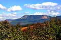
The Drakensberg is the eastern portion of the Great Escarpment, which encloses the central Southern African plateau. The Great Escarpment reaches its greatest elevation – 2,000 to 3,482 metres within the border region of South Africa and Lesotho.

The Province of the Transvaal, commonly referred to as the Transvaal, was a province of South Africa from 1910 until 1994, when a new constitution subdivided it following the end of apartheid. The name "Transvaal" refers to the province's geographical location to the north of the Vaal River. Its capital was Pretoria, which was also the country's executive capital.

Veld, also spelled veldt, is a type of wide open rural landscape in Southern Africa. Particularly, it is a flat area covered in grass or low scrub, especially in the countries of South Africa, Lesotho, Eswatini, Zimbabwe and Botswana. A certain sub-tropical woodland ecoregion of Southern Africa has been officially defined as the Bushveld by the World Wide Fund for Nature. Trees are not abundant—frost, fire and grazing animals allow grass to grow but prevent the build-up of dense foliage.

Mpumalanga is a province of South Africa. The name means "East", or literally "The Place Where the Sun Rises" in the Swazi, Xhosa, Ndebele and Zulu languages. Mpumalanga lies in eastern South Africa, bordering Eswatini and Mozambique. It constitutes 6.5% of South Africa's land area. It shares borders with the South African provinces of Limpopo to the north, Gauteng to the west, the Free State to the southwest, and KwaZulu-Natal to the south. The capital is Mbombela. Mpumalanga was formed in 1994 at the end of apartheid, when the Eastern Transvaal was merged with KaNgwane.

Hhohho is a region of Eswatini, located in the north western part of the country. Hhohho was named after the capital of King Mswati II, who expanded the Swazi territory to the north and west, taking in the districts of Barberton, Nelspruit, Carolina and Piet Retief. These areas were later acquired by what was the Province of Transvaal and today they form part of the Mpumalanga Province of South Africa. It has an area of 3,625.17 km², a population of 320,651 (2017), and is divided into 14 tinkhundla. The administrative center is the national capital of Mbabane. It borders Lubombo Region on the southeast and Manzini Region in the southwest.

Mbombela is a city in northeastern South Africa. It is the capital of the Mpumalanga province. Located on the Crocodile River, Mbombela lies about 110 km (68 mi) by road west of the Mozambique border, 330 km (210 mi) east of Johannesburg and about 82 km (51 mi) north of the Eswatini border. Mbombela was one of the host cities of the 2010 FIFA World Cup.

The Witwatersrand Gold Rush was a gold rush in 1886 that led to the establishment of Johannesburg, South Africa. It was a part of the Mineral Revolution.
The Netherlands–South African Railway Company or NZASM was a railway company established in 1887. The company was based in Amsterdam and Pretoria, and operated in the South African Republic (ZAR) during the late 19th century. At the request of ZAR president Paul Kruger, the NZASM constructed a railway line between Pretoria and Lourenço Marques in Portuguese East Africa.
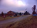
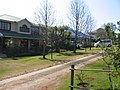
Barberton is a town in the Mpumalanga province of South Africa, which has its origin in the 1880s gold rush in the region. It is situated in the De Kaap Valley and is fringed by the Makhonjwa Mountains. It is 43 kilometres (27 mi) south of Mbombela and 360 kilometres (220 mi) east of Johannesburg.

Graskop is a small town in Mpumalanga province, South Africa. It was set up in the 1880s as a gold mining camp but it now serves as a tourist destination and the timber industry. “God’s Window”, a scenic view from the escarpment of the Lowveld below, is located outside the town.

Badplaas, officially eManzana, is a small town on the R38 road in eastern Mpumalanga, South Africa. It was established in 1876 on the Seekoeispruit, in the foothills of the Dlomodlomo Mountains, at the site of a sulphur spring that delivers ±30,000 litres of hot water per hour. Multiple sulphur springs are found around the area, including the one situated at Mkhingoma on the Mkhomazana river.
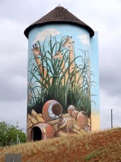
Kaapmuiden(Cape Mouth) is a small farming town situated at the confluence of the Kaap and Crocodile Rivers in Mpumalanga, South Africa. The town lies just off the N4 national highway and is marked by a large abandoned silo visible from the road. The silo has since been repainted to add to tourism appeal. The farms in the region produce sugarcane, subtropical fruit and vegetables. The town began as a junction on the Netherlands-South African Railway Company (NZASM)'s Pretoria - Delagoa Bay railway line.
The following lists events that happened during 1896 in South Africa.
Verulam is a township just north of Barberton in the Mpumalanga province of South Africa. It is situated in the De Kaap Valley and is fringed by the Makhonjwa Mountains. It is 43 kilometres (27 mi) south of Nelspruit and 360 kilometres (220 mi) to the east of Johannesburg.
Emjindini is a township adjacent to Barberton in the Mpumalanga province of South Africa. It is situated in the De Kaap Valley and is fringed by the Makhonjwa Mountains. It is 43 kilometres (27 mi) south of Nelspruit and 360 kilometres (220 mi) to the east of Johannesburg.
Sheba is a rural settlement northeast of Barberton in the Mpumalanga province of South Africa. It is situated in the De Kaap Valley and is fringed by the Makhonjwa Mountains. It is 35 kilometres (22 mi) south of Nelspruit and 360 kilometres (220 mi) to the east of Johannesburg. On Census 2011 maps it is marked as Bonanza Gold Mine, the name of an old worked-out mine.
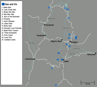
The Panorama Route is a scenic road in South Africa connecting several cultural and natural points of interest. The route, steeped in the history of South Africa, is in Mpumalanga province, centred around the Blyde River Canyon, the world's third largest canyon. It features numerous waterfalls, one of the largest afforested areas in South Africa, and several natural landmarks. The route starts at the foot of the Long Tom Pass just outside Lydenburg, following the natural descent from the Great Escarpment to the Lowveld, and ending at the border of the Mpumalanga and Limpopo provinces near the Echo Caves.

Pretoria–Maputo railway, also called Delagoa Bay railway, Iron railway and Eastern railway, is a railway that connects the city of Maputo, Mozambique, to the city of Pretoria, in South Africa. It is 567 km long, in 1067 mm gauge. The Mozambican section, between Maputo and Ressano Garcia, is managed by the state-owned Mozambique Ports and Railways (CFM) company, and it is officially known in Mozambique as the Ressano Garcia Line; in turn, on the South African stretch, between the cities of Komatipoort and Pretoria, the administration is done by the company Transnet Freight Rail.