
The Weser is a river in Northwestern Germany. Formed at Hannoversch Münden by the confluence of the rivers Fulda and Werra, it flows through Lower Saxony, then reaching the Hanseatic city of Bremen, before emptying 50 km (31 mi) further north at Bremerhaven into the North Sea. On the opposite (west) bank is the town of Nordenham at the foot of the Butjadingen Peninsula; thus, the mouth of the river is in Lower Saxony. The Weser has an overall length of 452 km (281 mi). Together with its Werra tributary, which originates in Thuringia, its length is 744 km (462 mi).
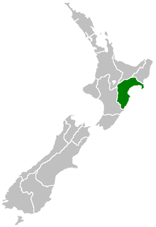
Hawke's Bay Region is a region of New Zealand on the east coast of the North Island. It is governed by Hawke's Bay Regional Council, which sits in the city of Napier. The region's name derives from Hawke Bay, which was named by Captain James Cook in honour of Admiral Edward Hawke.

The Black Rock Desert is a semi-arid region (in the Great Basin shrub steppe eco-region), of lava beds and playa, or alkali flats, situated in the Black Rock Desert–High Rock Canyon Emigrant Trails National Conservation Area, a silt playa 100 miles (160 km) north of Reno, Nevada that encompasses more than 300,000 acres (120,000 ha) of land and contains more than 120 miles (200 km) of historic trails. It is in the northern Nevada section of the Great Basin with a lakebed that is a dry remnant of Pleistocene Lake Lahontan.

The Dnieper is one of the major rivers of Europe, rising in the Valdai Hills near Smolensk, Russia, and flowing through Russia, Belarus and Ukraine to the Black Sea. It is the longest river of Ukraine and Belarus and the fourth-longest river in Europe. The total length is approximately 2,200 km (1,400 mi) with a drainage basin of 504,000 square kilometres (195,000 sq mi). The river is noted for its dams and hydroelectric stations. The Dnieper is an important navigable waterway for the economy of Ukraine and is connected via the Dnieper–Bug Canal to other waterways in Europe.

Karabük Province is a landlocked province in the northern part of Anatolia, located about 200 km (124 mi) north of Ankara, 115 km (71 mi) away from Zonguldak and 113 km (70 mi) away from Kastamonu. In 2010 it had a population of 227,610. The main city is Karabük which is located about 100 km (62 mi) south of the Black Sea coast.

The Slessor Glacier is a glacier at least 120 km long and 80 km wide, flowing west into the Filchner Ice Shelf to the north of the Shackleton Range. First seen from the air and mapped by the Commonwealth Trans-Antarctic Expedition (CTAE) in 1956. Named by the CTAE for RAF Marshal Sir John Slessor, chairman of the expedition committee.
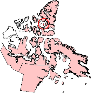
Graham Island is an uninhabited island in Qikiqtaaluk Region, Nunavut, Canada. A member of the Queen Elizabeth Islands and Canadian Arctic Archipelago, it is located in Norwegian Bay off the coast of Ellesmere Island. Located at 77°25'N 90°30'W it has an area of 1,378 km2 (532 sq mi), 55 kilometres (34 mi) long and 40 kilometres (25 mi) wide. It was named in 1910.

Mertz Glacier is a heavily crevassed glacier in George V Coast of East Antarctica. It is the source of a glacial prominence that historically has extended northward into the Southern Ocean, the Mertz Glacial Tongue. It is named in honor of the Swiss explorer Xavier Mertz.

Panega Glacier on Varna Peninsula, Livingston Island in the South Shetland Islands, Antarctica is situated southeast of the northeastern portion of Saedinenie Snowfield, south of Rose Valley Glacier, southwest of Debelt Glacier and north of lower Kaliakra Glacier. It drains the southeast slopes of Vidin Heights and flows into Moon Bay between Helis Nunatak and Perperek Knoll. The glacier extends 2 nautical miles in the southeast-northwest direction, and 1.6 nautical miles in the southwest-northeast direction. It is named after Zlatna Panega River in northern Bulgaria.

Pimpirev Glacier on Livingston Island in the South Shetland Islands, Antarctica is situated south of the glacial divide between the Drake Passage and Bransfield Strait, southeast of Tundzha Glacier, southwest of Saedinenie Snowfield, west of Perunika Glacier and east-northeast of Kamchiya Glacier. The feature extends 5.5 km in a southeast-northwest direction, and 1.8 km in northwest-southeast direction. The glacier drains southeastwards towards Pimpirev Beach, mostly terminating on the shore, and on several occasions penetrating the South Bay waters east-northeast of Ereby Point.

Srebarna Glacier on Livingston Island in the South Shetland Islands, Antarctica is situated east-northeast of Boyana Glacier, southeast of the head of Macy Glacier and southwest of Magura Glacier. It extends 2.3 km in southwest-northeast direction and 1.8 km in northwest-southeast direction, and drains southeast of Serdica Peak and the Great Needle Peak in Levski Ridge, Tangra Mountains to enter Bransfield Strait between Aytos Point and M'Kean Point.

The Great Wall of China is a series of fortifications made of stone, brick, tamped earth, wood, and other materials, generally built along an east-to-west line across the historical northern borders of China to protect the Chinese states and empires against the raids and invasions of the various nomadic groups of the Eurasian Steppe with an eye to expansion. Several walls were being built from as early as the 7th century BC; these were later joined together and made bigger by Qin Shi Huang (220–206 BC), the first Emperor of China. Little of that wall remains. Later on, many successive dynasties have repaired, maintained, and newly built multiple stretches of border walls. The most well-known of the walls were built during the Ming dynasty (1368–1644).

Beaumont-sur-Sarthe is a commune in the Sarthe department and Pays de la Loire region of north-western France.

Mangasuli is a village located in Northern Karnataka, India. It is located in the Athani taluk of Belgaum district in Karnataka. It has both Marathi and Kannada speaking people.
Apfel Glacier is a glacier about 5 nautical miles (10 km) wide and 20 nautical miles (40 km) long, flowing west-northwest along the south flank of the Bunger Hills and terminating in Edisto Ice Tongue. It was mapped from air photos taken by U.S. Navy Operation Highjump, 1946–47, and named by the Advisory Committee on Antarctic Names for Earl T. Apfel, professor of geology at Syracuse University, who served as geologist with the U.S. Navy Operation Windmill parties, 1947–48, which established astronomical control stations along Queen Mary, Knox and Budd Coasts.
Arneb Glacier or Hallett Glacier is a glacier 3 nautical miles (6 km) long and 2 nautical miles (4 km) wide, situated in a cliff-walled bay between Hallett Peninsula and Redcastle Ridge and flowing northwest into Edisto Inlet as a floating ice tongue. It was named by the New Zealand Geological Survey Antarctic Expedition, 1957–58, for USS Arneb, which in the 1957 season carried the buildings and stores for the establishment of Hallett Station and revisited the station in subsequent seasons.

Commandant Charcot Glacier is a prominent glacier about 3 nautical miles (6 km) wide and 12 nautical miles (22 km) long, flowing north-northwest from the continental ice to its terminus at the head of Victor Bay. It was delineated from aerial photographs taken by U.S. Navy Operation Highjump, 1946–47. The French Antarctic Expedition, 1950–1952, under Mario Marret sledged west along the coast to Victor Bay, close east of this glacier, in December 1952, and it was named by them for the polar ship Commandant Charcot which transported French expeditions to this area, 1948–1952.
Glen Glacier is a glacier at least 7 nautical miles (13 km) long, flowing south in the Shackleton Range of Antarctica to join Recovery Glacier to the west of the Read Mountains. It was first mapped in 1957 by the Commonwealth Trans-Antarctic Expedition (CTAE) and named for Alexander R. Glen, a member of the Committee of Management of the CTAE, 1955–58.

Thiru. Vi. Ka Nagar or TVK Nagar or Thiru. V. Kalyanasundaram Nagar, named after the Tamil scholar Thiru. V. Kalyanasundaram is a developed residential area in North Chennai, a metropolitan city in Tamil Nadu, India.


