
Zoutpansberg was the north-eastern division of the Transvaal, South Africa, encompassing an area of 25,654 square miles. The chief towns at the time were Pietersburg and Leydsdorp. It was divided into two districts prior to the first general election of the Union of South Africa in 1910. Since 2005 the area is divided into the Capricorn, Vhembe and Mopani district municipalities of Limpopo province.

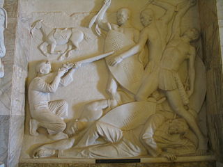
The Great Trek was a northward migration of Dutch-speaking settlers who travelled by wagon trains from the Cape Colony into the interior of modern South Africa from 1836 onwards, seeking to live beyond the Cape's British colonial administration. The Great Trek resulted from the culmination of tensions between rural descendants of the Cape's original European settlers, known collectively as Boers, and the British. It was also reflective of an increasingly common trend among individual Boer communities to pursue an isolationist and semi-nomadic lifestyle away from the developing administrative complexities in Cape Town. Boers who took part in the Great Trek identified themselves as voortrekkers, meaning "pioneers" or "pathfinders" in Dutch and Afrikaans.

The Boer republics were independent, self-governing republics formed by Dutch-speaking inhabitants of the Cape Colony and their descendants. The founders – variously named Trekboers, Boers, and Voortrekkers – settled mainly in the middle, northern, north-eastern and eastern parts of present-day South Africa. Two of the Boer republics achieved international recognition and complete independence: the South African Republic and the Orange Free State. The republics did not provide for the separation of church and state, initially allowing only the Dutch Reformed Church, and later also other Protestant churches in the Calvinist tradition. The republics came to an end after the Second Boer War of 1899–1902, which resulted in British annexation and later incorporation of their lands into the Union of South Africa.

Andries Wilhelmus Jacobus Pretorius was a leader of the Boers who was instrumental in the creation of the South African Republic, as well as the earlier but short-lived Natalia Republic, in present-day South Africa. The large city of Pretoria, executive capital of South Africa, is named after him.
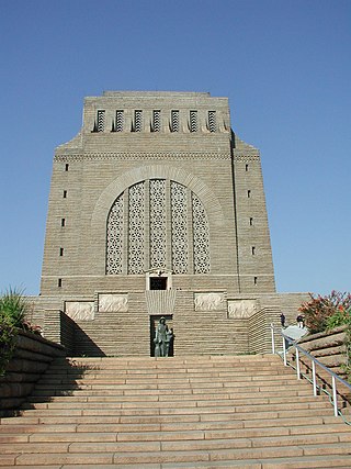
The Voortrekker Monument is located just south of Pretoria in South Africa. The granite structure is located on a hilltop, and was raised to commemorate the Voortrekkers who left the Cape Colony between 1835 and 1854. It was designed by the architect Gerard Moerdijk.

Andries Hendrik Potgieter, known as Hendrik Potgieter was a Voortrekker leader. He served as the first head of state of Potchefstroom from 1840 and 1845 and also as the first head of state of Zoutpansberg from 1845 to 1852.

Pieter Johannes "Piet" Potgieter was a South African Boer political figure. He was the acting head of state of Zoutpansberg from 1852 to 1854, and the first son of voortrekker Andries Potgieter.

The Volksraad of the South African Republic was the parliament of the former South African Republic (ZAR), it existed from 1840 to 1877, and from 1881 to 1902 in part of what is now South Africa. The body ceased to exist after the British Empire's victory in the Second Anglo-Boer War. The Volksraad sat in session in Ou Raadsaal in Church Square, Pretoria.

Lydenburg, also known as Mashishing, is a town in Thaba Chweu Local Municipality, on the Mpumalanga highveld, South Africa. It is situated on the Sterkspruit/Dorps River tributary of the Lepelle River at the summit of the Long Tom Pass. It has a long, rich history, ranging from AD 500 to the present. The name is derived from the Dutch Lijdenburg, or "Town of Suffering", and is named for the experiences of the white settlers. In Northern Sotho, Mashishing means "long green grass." Lydenburg has become the centre of the South African fly-fishing industry and is an agricultural, tourism and mining hub.

Winburg - Makeleketla is a small mixed farming town in the Free State province of South Africa.
The following lists events that happened during 1852 in South Africa.
The following lists events that happened during the 1790s in South Africa.

Stephanus Schoeman was President of the South African Republic from 6 December 1860 until 17 April 1862. His red hair, fiery temperament and vehement disputes with other Boer leaders earned him the moniker "Stormvogel den Noorden," "Storm bird of the North."
Petrus Lafras Uys (1797–1838) was a Voortrekker leader during the Great Trek.
Johan Arnold Smellekamp was a Dutchman who pioneered trade with the Boer Voortrekker states in South Africa and later became a civil servant, politician and law agent in the Orange Free State.
The Slachter's Nek Rebellion was an uprising by Boers in 1815 on the eastern border of the Cape Colony.
Schoemansdal was a settlement situated 16 km west of Louis Trichardt (Makhado), which had its origins during the Great Trek. It existed from 1848 to 1867, and functioned as the capital of an autonomous region until the S.A.R. Volksraad was established, when the outpost came under the supervision and regulations of the central government. The settlement was evacuated after only thirty years when attacked by Venda militants. The government rendered indecisive support and the town as torched by Katze-Katze on the night of 15 July 1867.
Voortrekker Fort/Ohrigstad Fort was constructed before 1847 to act as a refuge for local Voortrekker families due to the constant attacks of local Bantu tribes. It is situated in the Ohrigstad area of northern Mpumalanga province which was first settled by Europeans under the leadership of Andries Hendrik Potgieter.
The Voortrekker Fort situated on the farm, Elandsfontein, was constructed by the Voortrekkers under Commandant General A.M. Potgieter in 1842. A commemorative tablet of the former National Monuments Council states that the fort was built "for the protection of families with the view of possible departure of a commando against the British troops from Natal".
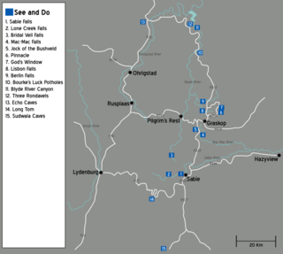
The Panorama Route is a scenic road in South Africa connecting several cultural and natural points of interest. The route, steeped in the history of South Africa, is in Mpumalanga province, centred around the Blyde River Canyon, the world's third largest canyon. It features numerous waterfalls, one of the largest afforested areas in South Africa, and several natural landmarks. The route starts at the foot of the Long Tom Pass just outside Lydenburg, following the natural descent from the Great Escarpment to the Lowveld, and ending at the border of the Mpumalanga and Limpopo provinces near the Echo Caves.


