This article relies largely or entirely on a single source .(May 2025) |
Witfontein | |
|---|---|
 Witfontein  Witfontein | |
| Coordinates: 25°14′02″S29°02′24″E / 25.234°S 29.040°E | |
| Country | South Africa |
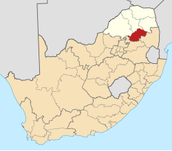
| Province | Limpopo |
| District | Sekhukhune |
| Municipality | Elias Motsoaledi |
| Area | |
• Total | 1.78 km2 (0.69 sq mi) |
| Population (2011) [1] | |
• Total | 2,832 |
| • Density | 1,600/km2 (4,100/sq mi) |
| Racial makeup (2011) | |
| • Black African | 99.9% |
| • Indian/Asian | 0.1% |
| • Other | 0.1% |
| First languages (2011) | |
| • Northern Sotho | 45.2% |
| • S. Ndebele | 34.6% |
| • Zulu | 8.3% |
| • Swazi | 3.1% |
| • Other | 8.8% |
| Time zone | UTC+2 (SAST) |
| Postal code (street) | 0477 |
| 0477PO box | 0477 |
Witfontein is a town in Sekhukhune District Municipality in the Limpopo province of South Africa.