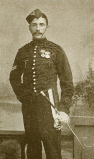
Alfred Ernest Ind VC was an English recipient of the Victoria Cross, the highest and most prestigious award for gallantry in the face of the enemy that can be awarded to British and Commonwealth forces.

Cornelia is a town on the R103 road in the Free State province of South Africa. J.D. Odendaal bought the farm "Sugarloaf" for a sum of R2,000. They settled there in 1876. At that time it was in the Harrismith district. There were no boundary fences and wild dogs, warthogs and wildebeest were plentiful in the open grassveld.

Pretoria FM, formerly Radio Pretoria is an Afrikaans community-based radio station in Pretoria, South Africa. It broadcasts 24 hours a day in stereo on 104.2 FM in the greater Pretoria area. Various other transmitters in South Africa broadcast the station's content further afield, while the station is also available on Sentech's digital satellite platform. The station was founded seven months before the 1994 elections. From the start, it identified itself as a radio station for the Afrikaans speaking community. For a brief period, it broadcast informally from a makeshift studio east of Pretoria. Broadcasts were made possible with the help of among others, retired SABC employees. Post-1994, Radio Pretoria struggled for years to secure a permanent broadcasting license from the ANC government.
Prince Sethati was the fifth son of King Tsotetsi who was the leader of Batlokwa ba Mokgalong in the mid-1700s, from which they trace their history. Sethati gave birth to three children namely Makume, Mokgitlinyane and Mankane. Sethati was born in the Nts'oana-Tsatsi, Tafelkop area in the Free State are and most of his descendants are in South Africa and Lesotho area.
Massalongia griseolobulata is a species of lichen in the family Massalongiaceae. Found in the Tristan da Cunha–Gough Island, it was described as a new species in 2010 by Norwegian lichenologist Dag Øvstedal. The type specimen was collected from the lower slopes of Tafelkop on Gough Island). Here it was found growing on the trunk of a treefern at an altitude of 270 m (890 ft). The species is known only from the type locality.


