
The Lake of the Arbuckles is a reservoir located in southern Oklahoma, 8 miles (13 km) southwest of Sulphur in Murray County. The lake covers 2,350 acres (950 ha) and is a principal water supply reservoir for the city of Ardmore, some 30 mi (48 km) to the southwest. It also supplies water to the cities of Sulphur, Davis, Wynnewood and a large oil refinery near Wynnewood. The lake also provides flood control, fish and wildlife habitat and recreation opportunities.
Lephalale, formerly known as Ellisras, is a coal mining town in the Limpopo province of South Africa immediately east of the Waterberg Coalfield. The town was established as Ellisras in 1960 and named after Patrick Ellis and Piet Erasmus who settled on a farm there in the 1930s. In 2002, Ellisras was renamed Lephalale by the provincial government of Limpopo, after the main river that crosses the municipality. Lephalale is derived from the setswana language meaning "to flow".
A feasibility study is an assessment of the practicality of a project or system. A feasibility study aims to objectively and rationally uncover the strengths and weaknesses of an existing business or proposed venture, opportunities and threats present in the natural environment, the resources required to carry through, and ultimately the prospects for success. In its simplest terms, the two criteria to judge feasibility are cost required and value to be attained.

The California Department of Water Resources (DWR) is part of the California Natural Resources Agency and is responsible for the management and regulation of the State of California's water usage. The department was created in 1956 by Governor Goodwin Knight following severe flooding across Northern California in 1955, where they combined the Division of Water Resources of the Department of Public Works with the State Engineer's Office, the Water Project Authority, and the State Water Resources Board. It is headquartered in Sacramento.
The Nam Ngum Dam is a hydroelectric dam on the Nam Ngum River, a major tributary of the Mekong River in Laos. It was the first hydropower dam built in the Lao PDR.

The Indian rivers interlinking project is a proposed large-scale civil engineering project that aims to effectively manage water resources in India by linking rivers using a network of reservoirs and canals to enhance irrigation and groundwater recharge and reduce persistent floods in some parts and water shortages in other parts of the country. India accounts for 18% of global population and about 4% of the world's water resources. One of the solutions to solve the country's water woes is to link its rivers and lakes.
The Water Resources Development Act of 1986 is part of Pub. L.Tooltip Public Law 99–662, a series of acts enacted by Congress of the United States on November 17, 1986.
The Water Resources Development Act of 1990, Pub. L.Tooltip Public Law 101–640, was enacted by Congress of the United States on November 12, 1990. Most of the provisions of WRDA 1990 are administered by the United States Army Corps of Engineers.
Water Resources Development Act of 1988, Pub. L.Tooltip Public Law 100–676, is a public law passed by Congress on November 17, 1988 concerning water resources in the United States in the areas of flood control, navigation, dredging, environment, recreation, water supply, beach nourishment and erosion.

Botswana's principal tourist attractions are its game reserves, with hunting and photographic safaris available. Other attractions include the Okavango Delta region, which during the rainy season is a maze of waterways, islands, and lakes. The tourism industry also helped to diversify Botswana's economy from traditional sources such as diamonds and beef and created 23,000 jobs in 2005.
The Water Resources Development Act of 1992, Pub. L.Tooltip Public Law 102–580, was enacted by Congress of the United States on October 31, 1992. Most of the provisions of WRDA 1992 are administered by the United States Army Corps of Engineers.

Aimata Dam (相俣ダム) is a dam built on the Akaya River, part of the class-A Tonegawa River system at Aimata in the city of Minakami, in the Tone District of Gunma Prefecture, Japan.
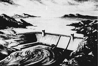
The Rampart Dam or Rampart Canyon Dam was a project proposed in 1954 by the U.S. Army Corps of Engineers to dam the Yukon River in Alaska for hydroelectric power. The project was planned for Rampart Canyon just 31 miles (50 km) southwest of the village of Rampart, Alaska, about 105 miles (169 km) west-northwest of Fairbanks.
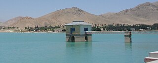
Qargha Dam is located in the town of Qargha, about 10 mi (16 km) west from the Shahr-e Naw neighborhood of Kabul, Afghanistan. It is an embankment dam built on the Paghman River, with a side channel spillway under the road running on top of the dam. Its reservoir can hold up to 12,000,000 m3 (420,000,000 cu ft) of water, which is used for irrigation purposes. The dam is named after the town.

O'Shaughnessy Dam is a 430-foot-high (131 m) concrete arch-gravity dam in Tuolumne County, California, United States. It impounds the Tuolumne River, forming the Hetch Hetchy Reservoir at the lower end of Hetch Hetchy Valley in Yosemite National Park, about 160 miles (260 km) east of San Francisco. The dam and reservoir are the source for the Hetch Hetchy Aqueduct, which provides water for over two million people in San Francisco and other municipalities of the west Bay Area. The dam is named for engineer Michael O'Shaughnessy, who oversaw its construction.
The Mirador mine is a large copper mine located in the Amazonian province of Zamora-Chinchipe in southern Ecuador. It is one of the largest copper reserves in Ecuador, and the first industrial-scale copper project to be developed in the country. The project has generated an environmental conflict that is emblematic in the national political debate on mining.
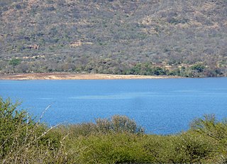
The De Hoop Dam is a gravity dam on the Steelpoort River, near Burgersfort, Limpopo, South Africa. Its purpose is to enable the extraction of rich mineral deposits in the eastern Limpopo province, and to supply water to towns, industries and communities in the Sekhukhune district, where service delivery was of a poor standard.
The Sunshine Coast Light Rail is a proposed light rail system for the Sunshine Coast region of Queensland, Australia. The light rail system would link Maroochydore with Caloundra via Mooloolaba and Kawana and was planned to bring a frequent, high-quality light rail service to meet the region's predicted growth. The system underwent feasibility studies in 2015.

Masani barrage, also Masani bridge, a barrage on the seasonal Sahibi River completed in 1989, is named after the Masani village in Rewari District of Haryana in India. Masani barrage also serves as a bridge on NH 919. Water storage in the barrage was made perennial in 2017 after a gap of 50 years. This barrage is important part of ecological corridor along the route of Sahibi river which traverses from Aravalli hills in Rajasthan to Yamuna via Matanhail forest, Chhuchhakwas-Godhari, Khaparwas Wildlife Sanctuary, Bhindawas Wildlife Sanctuary, Outfall Drain Number 8 and 6, Sarbashirpur, Sultanpur National Park, Basai and The Lost Lake (Gurugram).
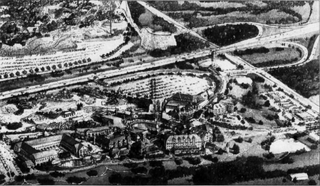
Six Flags Entertainment Village was the working title for a proposed 134-acre (54 ha) entertainment complex in Gurnee, Illinois, across and west of Six Flags Great America, located near Interstate 94. Owned by Six Flags and developed by Prism Development Co., the complex would have cost US$400 million. This project was intended to generate over US$5,000,000 a year. The complex was projected to draw in 400,000 visitors annually and would have been built in multiple phases.


