African Americans are an ethnic group of Americans with total or partial ancestry from any of the black racial groups of Africa. The phrase generally refers to descendants of enslaved black people who are from the United States.

South Africa is divided into nine provinces. On the eve of the 1994 general election, South Africa's former homelands, also known as Bantustans, were reintegrated and the four existing provinces were divided into nine. The twelfth, thirteenth and sixteenth amendments to the constitution changed the borders of seven of the provinces.
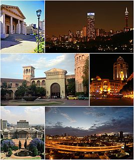
Johannesburg, informally known as Jozi,Joburg or "the city of gold", is the largest city in South Africa and one of the 50 largest urban areas in the world. It is the provincial capital and largest city of Gauteng, which is the wealthiest province in South Africa. Johannesburg is the seat of the Constitutional Court. The city is located in the mineral-rich Witwatersrand range of hills and is the centre of large-scale gold and diamond trade. It was one of the host cities of the official tournament of the 2010 FIFA World Cup.

The population of South Africa is about 58.8 million people of diverse origins, cultures, languages, and religions. The 2011 South African census was the last held and the next will be in 2021.

Witzenberg Municipality is a local municipality located within the Cape Winelands District Municipality, in the Western Cape province of South Africa. As of 2011 it had a population of 115,946.
Swartland Municipality is a municipality located in the Western Cape Province of South Africa. Malmesbury is the seat of the municipality. As of 2016, it had a population of 133,762. Its municipality code is WC015.
Race and ethnicity in the United States is a complex topic because the United States of America has a racially and ethnically diverse population. At the federal level, race and ethnicity have been categorized separately.

The National Census of 2001 was the 2nd comprehensive national census of the Republic of South Africa, or Post-Apartheid South Africa. It undertook to enumerate every person present in South Africa on the census night between 9–10 October 2001 at a cost of R987,000,000.
White South Africans are South Africans descended from any of the white racial or ethnic groups of Europe. In linguistic, cultural and historical terms, they are generally divided into the Afrikaans-speaking descendants of the Dutch East India Company's original settlers, known as Afrikaners, and the Anglophone descendants of predominantly British colonists. In 2016, 57.9% were native Afrikaans speakers, 40.2% were native English speakers, and 1.9% spoke another language as their mother tongue, such as Portuguese or German. White South Africans are by far the largest European-descended population group in Africa.
Ugu is one of the 11 districts of KwaZulu-Natal province of South Africa. Ugu is Zulu for "coast". It governs the KZN South Coast and its seat is Port Shepstone. The majority of its 722,484 people speak IsiZulu. The district code is DC21.
Pixley ka Seme is one of the 5 districts of the Northern Cape province of South Africa. The seat of Pixley ka Seme is De Aar. The majority (77%) of its 186,351 people speak Afrikaans as first language. The district code is DC7. It is named after Pixley ka Isaka Seme, one of the founders of the African National Congress.

Umhlanga is an affluent residential, commercial and resort town north of Durban on the coast of KwaZulu-Natal, South Africa. It is part of the eThekwini Metropolitan Municipality, created in 2000, which includes the greater Durban area. The name means "place of reeds" in the Zulu language, and the correct pronunciation of "hl" in Umhlanga is similar to the Welsh "ll". It is bordered by Durban North to the south and Mt Edgecombe to the west.

South Africa is a secular state with a diverse religious population. Its constitution guarantees freedom of religion. Many religions are represented in the ethnic and regional diversity of the population. Christianity, especially in its Protestant forms, predominates.
South Africa, officially the Republic of South Africa (RSA), is the southernmost country in Africa. It is bounded to the south by 2,798 kilometres (1,739 mi) of coastline of Southern Africa stretching along the South Atlantic and Indian Oceans; to the north by the neighbouring countries of Namibia, Botswana, and Zimbabwe; and to the east and northeast by Mozambique and Eswatini (Swaziland); and it surrounds the enclaved country of Lesotho. South Africa is the largest country in Southern Africa and the 24th-largest country in the world by land area and, with over 58 million people, is also the world's 24th-most populous nation. It is the southernmost country on the mainland of the Old World or the Eastern Hemisphere, and the most populous country located entirely south of the equator. About 80 percent of South Africans are of Bantu ancestry, divided among a variety of ethnic groups speaking different African languages, nine of which have official status. The remaining population consists of Africa's largest communities of European, Asian (Indian), and multiracial (Coloured) ancestry.
Bushbuckridge (Mapulaneng) is the main town in Bushbuckridge Local Municipality, Ehlanzeni District, Mpumalanga, South Africa. The name Bushbuck Ridge was given because of the large herds of bushbuck found here in the 1880s, and the prominent WNW-ESE ridge in the southeastern part of the municipality. The town of Bushbuckridge grew around a trading store that opened in 1884.
Porterville is a town in the Western Cape province in South Africa.

Burgersdorp is a medium-sized town in Gariep in the Joe Gqabi District Municipality of the Eastern Cape province of South Africa.

Matjhabeng Local Municipality is an administrative area in the Lejweleputswa District of the Free State in South Africa, that includes the city of Welkom. The name is a Sesotho word meaning "where nations meet". It is derived from the migrant labour system where people from various countries like Lesotho, Mozambique, etc. meet to work in the mines of the Goldfields.

The South African National Census of 2011 is the 3rd comprehensive census performed by Statistics South Africa.

Richwood is a suburb of Cape Town, South Africa, situated 15 kilometres (9.3 mi) north-east of the city centre alongside the N7 freeway. According to the 2011 census it has a population of 2,988 residents in 963 households. The name is a portmanteau of "Richmond Park" and "Goodwood".


