Rustenburg Municipality is a local municipality within the Bojanala Platinum District Municipality, in the North West province of South Africa. Rustenburg is situated at the foot of the Magalies mountain range. Rustenburg was proclaimed a township in 1851. The city of Rustenburg is situated some 112 km northwest from both Johannesburg and Pretoria. It is a malaria-free area. Rustenburg is the fastest growing municipality in South Africa, with the population rising from 387,096 in 2001 to 449,776 in 2007. It is the most populous municipality in the North West province.

Randfontein Local Municipality was a local municipality in West Rand District Municipality, Gauteng, in South Africa. After municipal elections on 3 August 2016, it was merged with the Westonaria Local Municipality to form the larger Rand West City Local Municipality.

Gariep Local Municipality is a defunct local municipality in Joe Gqabi District Municipality, Eastern Cape. The municipality was merged with Maletswai Local Municipality immediately after the August 2016 Local Municipal Elections to form the new Walter Sisulu Local Municipality.

Thulamela Municipality is a local municipality within the Vhembe District Municipality, in the Limpopo province of South Africa. Its municipal boundaries were greatly altered after the 2016 municipal elections when much of the area that formerly belonged to the municipality, including the town of Malamulele, was incorporated into the newly formed Collins Chabane Local Municipality. It is named after the Thulamela ruins located near the Pafuri Gate of the Kruger National Park.

Umjindi was a local municipality of the Ehlanzeni District in Mpumalanga, South Africa. Barberton was the seat of the municipality. The municipality had a population of 53,744 according to the 2001 census.

Albert Luthuli Municipality is a local municipality within the Gert Sibande District Municipality, in the Mpumalanga province of South Africa. It was named after Albert Luthuli. Carolina is the seat of the municipality.

Mookgophong Local Municipality was a municipality located in the Waterberg District Municipality of Limpopo province, South Africa. The seat of Mookgophong Local Municipality was Mookgophong.
Moses Kotane Municipality is a local municipality within the Bojanala Platinum District Municipality, in the North West province of South Africa. It is named in memory of Moses Kotane. The seat of the municipality is Mogwase.

Mahikeng Municipality is a local municipality within the Ngaka Modiri Molema District Municipality, in the North West province of South Africa. Mahikeng is a Setswana word meaning "place of rocks".

King Sabata Dalindyebo Municipality is a local municipality situated in the inland of the Eastern Cape province of South Africa. The municipality includes the towns of Mthatha and Mqanduli. The King Sabata Dalindyebo Municipality is one of the seven local municipalities within the OR Tambo District Municipality.

Mnquma Municipality is a local municipality within the Amatole District Municipality, in the Eastern Cape of South Africa.

Umzimvubu Municipality is a local municipality within the Alfred Nzo District Municipality, in the Eastern Cape province of South Africa. Umzimvubu, the name of the Mzimvubu River, is an isiXhosa word meaning "home of the hippopotamus". The municipal area comprises an area of 2506 square kilometres. The municipality has undergone a number of amendments in terms of municipal and ward demarcation which has a profound impact on planning in the area.
Nkonkobe Local Municipality was an administrative area in the Amatole District of the Eastern Cape in South Africa. The municipality is named after the Winterberg mountain range, Nkonkobe in isiXhosa. The seat, as well as most offices, of the Municipality are in Fort Beaufort, but the Council's chambers in Alice are generally used for council meetings, being better equipped. Other towns served by the municipality are Seymour, Balfour, Hogsback and Middledrift. After municipal elections on 3 August 2016 it was merged into the larger Raymond Mhlaba Local Municipality.

Lukhanji Local Municipality was an administrative area in the Chris Hani District of the Eastern Cape in South Africa. Lukhanji is a Xhosa name for the mountain that runs from the eastern side of Queenstown to the western side. After municipal elections on 3 August 2016 it was merged into the larger Enoch Mgijima Local Municipality.

Mthonjaneni is an administrative area in the King Cetshwayo District of KwaZulu-Natal in South Africa.
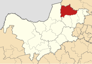
uMfolozi Local Municipality is a local municipality within the King Cetshwayo District Municipality of KwaZulu-Natal in South Africa. It is situated around the town of KwaMbonambi, to the north of Richard's Bay, stretching from the Indian Ocean to the edge of the Hluhluwe–Imfolozi Park.

Raymond Mhlaba Municipality is a local municipality, in the Eastern Cape province of South Africa. It was established after the August 2016 local elections by merging the Nkonkobe and Nxuba local municipalities.

Inkosi Langalibalele Municipality is a local municipality within the uThukela District Municipality, in the KwaZulu-Natal province of South Africa. It was established after the 2016 South African municipal elections by merging the Imbabazane and uMtshezi local municipalities.

Ray Nkonyeni Municipality is a local municipality within the Ugu District Municipality in South Africa. It is located on the south coast of KwaZulu-Natal. It was established after the August 2016 local elections by merging the Ezinqoleni and Hibiscus Coast local municipalities. As of 2022 it has a population of 362,134.
The Mbombela Local Municipality is a Local Municipality in Mpumalanga, South Africa. It was formed in 2016 after the merger of the Umjindi Local Municipality and the former Mbombela municipality. The council consists of ninety members elected by mixed-member proportional representation. Forty-five councillors are elected by first-past-the-post voting in forty-five wards, while the remaining twenty are chosen from party lists so that the total number of party representatives is proportional to the number of votes received. In the election of 1 November 2021 the African National Congress (ANC) won a majority of fifty-nine seats.