Related Research Articles

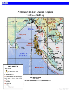
Myanmar is the northwesternmost country of mainland Southeast Asia. It lies along the Indian and Eurasian Plates, to the southeast of the Himalayas. To its west is the Bay of Bengal and to its south is the Andaman Sea. It is strategically located near major Indian Ocean shipping lanes. The neighboring countries are China, India, Bangladesh, Thailand and Laos.

The San Andreas Fault is a continental transform fault that extends roughly 1,200 kilometers (750 mi) through California. It forms the tectonic boundary between the Pacific Plate and the North American Plate, and its motion is right-lateral strike-slip (horizontal). The fault divides into three segments, each with different characteristics and a different degree of earthquake risk. The slip rate along the fault ranges from 20 to 35 mm /yr.
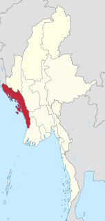
Rakhine State is a state in Myanmar (Burma). Situated on the western coast, it is bordered by Chin State to the north, Magway Region, Bago Region and Ayeyarwady Region to the east, the Bay of Bengal to the west and the Chittagong Division of Bangladesh to the northwest. It is located approximately between latitudes 17°30' north and 21°30' north and longitudes 92°10' east and 94°50' east. The Arakan Mountains or Rakhine Yoma separated Rakhine State from central Burma from North to South. Off the coast of Rakhine State there are some fairly large islands such as Ramree, Cheduba and Myingun. Rakhine State has an area of 36,762 square kilometres (14,194 sq mi) and its capital is Sittwe.

The Chin Hills are a range of mountains in Chin State, northwestern Burma (Myanmar), that extends northward into India's Manipur state.

The Arakan Mountains, also known as the Rakhine Mountains, are a mountain range in western Myanmar, between the coast of Rakhine State and the Central Myanmar Basin, in which flows the Irrawaddy River. It is the most prominent of a series of parallel ridges that arc through Assam, Nagaland, Manipur, Mizoram and Myanmar.
Myawaddy Mingyi U Sa was a Konbaung-era Burmese poet, composer, playwright, general and statesman. In a royal service career that spanned over six decades, the Lord of Myawaddy served under four kings in various capacities, and was a longtime secretary to King Bagyidaw. Multi-talented Sa is best remembered for his innovative contributions to classical Burmese music and drama, as well as for his brilliant military service.

The Rakhine people or Arakanese people are a Southeast Asian ethnic group in Myanmar (Burma) forming the majority along the coastal region of present-day Rakhine State. They possibly constitute 5.53% or more of Myanmar's total population, but no accurate census figures exist. Rakhine people also live in the southeastern parts of Bangladesh, especially in Chittagong Division and Barisal Division. A group of Rakhine descendants, living in the Chittagong Hill Tracts of Bangladesh at least since the 16th century, are known as the Marma people or Mog people.

The White Wolf Fault is a fault in southern California, located along the northwestern transition of the Tejon Hills and Tehachapi Mountains with the San Joaquin Valley. It is north of the intersection of the San Andreas Fault and the Garlock Fault, and roughly parallel with the latter. It is classed as a reverse fault with a left lateral (sinistral) component.
The Daai are an ethnic group living in Chin State, Myanmar. The Daai consist of 32 Chin tribes, which have been registered by the Government of Burma since 1890. The recent Military Regime’s census mentions the Daai tribe as the 62nd of 135 tribes of Burma. Researchers refer to them as the Daai group in the ethnic survey book of Burma. The Daai Chin appear to be of Mongolian, Indo-Chinese, and Tibeto-Burman descent. The Daai people live in the Mindat, Paletwa, Matupi and Kanpetlet townships of Southern Chin State in Burma. There are more than 180 Daai villages with a total population of somewhere between 40,000 and 50,000. Their population makes the Daai-Chin the majority tribe of the Southern Chin Hills.

Zogam known as Zoland, Lushai Hills, Kuki Hills, lies in the northwest corner of the Mainland Southeast Asia landmass. This is the traditional ancestry homeland of the Zo people or Zomi who lived in this area before the colonial period under British rulership.
The Kabaw Valley also known as Kubo valley is a highland valley in Myanmar's western Sagaing division, close to the border with India's Manipur. The valley is located between Heerok or Yoma ranges of mountains, which constitute the present day border of Manipur, and the Chindwin River. The valley is home to a number of ethnic groups including the Meitei, the Thadou people, Kuki people, the Mizo, the Kadu and the Kanan.

The 2011 Burma earthquake occurred with a magnitude 6.9 Mw on 24 March. It had an epicenter in the eastern part of Shan State in Burma (Myanmar) with a hypocenter 10 km deep. It had two aftershocks, one of magnitude 4.8, another at magnitude 5.4, and two subsequent shocks at magnitude 5.0 and 6.2. The quake's epicentre was 70 miles (110 km) from the northern Thai city of Chiang Rai, north of Mae Sai and southeast of Kentung.
The Three Pagodas Fault is a right-lateral displacement strike-slip fault between Burma and Thailand named after the Three Pagodas Pass. It developed as a consequence of the collision between the Indian and the Eurasian Plate. The Three Pagodas Fault Zone (TPFZ) is a roughly 50 km wide zone separating the westernmost range of the Tenasserim Hills from the Tenasserim coast in Myanmar. The whole area is marked by a great number of fault traces and homoclinal ridges of Paleozoic limestone.

The 1762 Arakan earthquake occurred at about 17:00 local time on 2 April, with an epicentre somewhere on the coast from Chittagong to Arakan in modern Burma. It had an estimated magnitude of as high as 8.8 on the moment magnitude scale and a maximum estimated intensity of XI (Extreme) on the Mercalli intensity scale. It triggered a local tsunami in the Bay of Bengal and caused at least 200 deaths. The earthquake was associated with major areas of both uplift and subsidence. It is also associated with a change in course of the Brahmaputra River to from east of Dhaka to 150 kilometres (93 mi) to the west via the Jamuna River.

Arakan is a historic coastal region in Southeast Asia. Its borders faced the Bay of Bengal to its west, the Indian subcontinent to its north and Burma proper to its east. The Arakan Mountains isolated the region and made it accessible only by the Indian subcontinent and the sea. The region now forms the Rakhine State in Myanmar.

The 1946 Sagaing earthquakes struck central Burma at 15:17 local time on September 12. The first earthquake registered a magnitude of 8.0 and was followed-up by an M7.8 main shock. Both events remain some of the largest in the country since the 1762 Arakan Earthquake.
The 1930 Bago earthquake, also known as the Swa earthquake struck Burma on May 5 with a magnitude between 7.3 and 7.5. This earthquake was one of the most destructive to hit the country and one of several earthquakes to affect the country between 1929 and 1931. Extensive damage was reported in the southern part of the country, and more than 550 people were killed.
The 1988 Myanmar-India earthquake struck the Sagaing Region of Myanmar, about 30 kilometres (19 mi) from the border with India on 6 August at 7:06 am MMT with a moment magnitude of 7.3. It was the largest earthquake in the world that year, after a Mw 7.8 in the Gulf of Alaska. Thirty eight people were killed, and 30 were injured as a result. Serious damage were reported in India and Bangladesh. The earthquake was reportedly felt in the Soviet Union.
The years between 1929 to 1932 were a significant period for Burma, with a series of major earthquakes destroying cities in the country during British rule.
References
- ↑ "In India, Bangladesh and Myanmar, a Major Earthquake is Inevitable". Thequint.com. Retrieved 23 October 2017.
| | This tectonics article is a stub. You can help Wikipedia by expanding it. |