
Palembang is the capital city of the Indonesian province of South Sumatra. The city proper covers 352.51 square kilometres on both banks of the Musi River in the eastern lowlands of southern Sumatra. It had a population of 1,668,848 at the 2020 Census; the official estimate as at mid 2023 was 1,772,492. Palembang is the second most populous city in Sumatra, after Medan, and the twelfth most populous city in Indonesia.

South Sumatra is a province of Indonesia, located in the southeast of the island of Sumatra. The capital and largest city of the province is the city of Palembang. The province borders the provinces of Jambi to the north, Bengkulu to the west and Lampung to the south, as well a maritime border with the Bangka Belitung Islands to the east. It is the largest province in the island of Sumatra, and it is slightly smaller than Portugal, the department of Boquerón in Paraguay or the U.S. state of Maine. The Bangka Strait in the east separates South Sumatra and the island of Bangka, which is part of the Bangka Belitung Islands province. The province has an area of 91,592.43 km2 (35,364 sq mi) and had a population of 8,467,432 at the 2020 census; the official estimate as at mid-2023 was 8,743,522. The province is rich in natural resources, such as petroleum, natural gas and coal. The province is inhabited by many different Malay sub ethnic groups, with Palembangese being largest ethnic group. Most speak the Palembang language, which is mutually intelligible to both Indonesian and local Palembang Malay. Other ethnic groups include the Javanese, Sundanese, Minangkabau and Chinese. Most are concentrated in urban areas and are largely immigrants from other parts of Indonesia.

Karimnagar is a city and District Headquarters in the Indian state of Telangana. Karimnagar is a major urban agglomeration in the state. It is third largest City in the state and Municipal Corporation and is the headquarters of the Karimnagar district. It is situated on the banks of Manair River, which is a tributary of the Godavari River. It is the third largest and fastest growing urban settlement in the state, according to the 2011 census. It has registered a population growth rate of 45.46% and 38.87% respectively over the past two decades between 1991 and 2011, which is the highest growth rate among major cities of Telangana. It serves as a major educational and health hub for the northern districts of Telangana. It is a major business center and widely known for its agricultural and granite industries, earning the nickname "City of Granites."

Telangana is a state in India situated in the south-central part of the Indian subcontinent on the high Deccan Plateau. It is the eleventh largest state and the twelfth most populated state in India as per the 2011 census. On 2 June 2014, the area was separated from the northwestern part of United Andhra Pradesh as the newly formed state of Telangana, with Hyderabad as its capital. Telugu, one of the classical languages of India, is the most widely spoken and the primary official language of the state.

The Musi River is a major tributary of the Krishna River in the Deccan Plateau, flowing through Telangana, India. The river's historical name is Muchukunda. Hyderabad stands on the banks of the Musi River, which divides the historic Old City from the new city. The Musi River flows into Himayat Sagar and Osman Sagar, which are artificial lakes that act as reservoirs that once supplied the twin cities of Hyderabad and Secunderabad with drinking water. It originates in the Ananthagiri Hills, near Vikarabad. It generally flows towards the east, turning south at Chittaloor. It flows into the Krishna River at Vadapally near Miryalaguda in Nalgonda district.

Nalgonda district is a district in the Telangana state of India. Nalgonda district has the highest number of mandals in the state with 31 mandals. The district shares boundaries with Suryapet, Rangareddy, Yadadri and Nagarkurnool districts and with the state boundary of Andhra Pradesh. In terms of area, Nalgonda is the largest district with an area of 7222.78 km2 in the state.

Ranga Reddy district is a district in the Indian state of Telangana. The district headquarters is located at Kongara Kalan Village, Ibrahimpatnam Mandal. The district was named after the former deputy chief minister of the United Andhra Pradesh, K. V. Ranga Reddy. The district shares boundaries with Nalgonda, Yadadri Bhuvanagiri, Hyderabad, Medchal–Malkajgiri, Nagarkurnool, Mahabubnagar, Sangareddy and Vikarabad districts.

The Musi River is a river in Southern Sumatra, Indonesia. It flows from south-west to north-east, from the Barisan Mountains range that form the backbone of Sumatra, in Kepahiang Regency, Bengkulu Province, to the Bangka Strait that forms an extension of the South China Sea. The Musi is about 750 kilometers long, and drains most of South Sumatra province. After flowing through Palembang, the provincial capital, it joins with several other rivers, including the Banyuasin River, to form a delta near the town of Sungsang. The river, dredged to a depth of about 8 meters, is navigable by large ships as far as Palembang, which is the site of major port facilities used primarily for the export of petroleum, rubber and palm oil.
Khanapur known as Khanapura is a panchayat town in Belagavi district, Karnataka, India. It is about 26 km from Belagavi, the administrative capital of the district. The Khanapur Municipal Council governs the town. Khanapur is the headquarters for Khanapur taluk. The town is on the Belgaum-Panaji National Highway, NH 4A. Khanapur is well connected by train and road to important cities in Karnataka, Goa, and Maharashtra. Kannada is the official language.

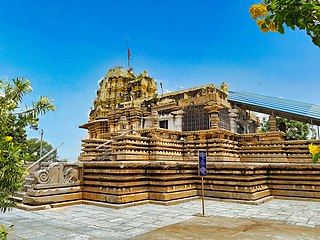
Mahabubabad is a city and the district headquarters of Mahabubabad district in the Indian state of Telangana. It is on the west bank of the Munneru, which is one of the tributaries of the River Krishna. Mahabubabad is known for the Bayyaram Mines. Kuravi virabadraswamy temple
Armoor is a city in Nizamabad district, in the state of Telangana in India. Armoor is situated on NH 63. In the past, it was called Navanathapuram since it has nine mountains around the city Armoor is a variation of it.

Hyderabad is located in central Telangana and is spread over an area of 2,500 km2. The city lies in the Deccan Plateau and rises to an average height of 536 m above the sea level. The city lies at 17.366° N latitude and 78.476° E longitude.

The State Central Library Hyderabad, known as the State Central Library (SCL) earlier known as Kutub Khana Asafia, is a public library in Hyderabad, Telangana. The library was first established in 1891 at a location in Abids where the General Post Office is today situated. The library was shifted to its present location in 1936 and today is one of the most imposing structures in the city. The building housing the library was granted heritage status in 1998 by INTACH, Hyderabad.

The Ogan River is a river in South Sumatra, Indonesia. It is a tributary of the Musi River in Southern Sumatra. Flowing entirely in the South Sumatra province, it rises in Barisan Mountains and meanders slowly eastwards to join the Musi at Kertapati, Palembang. The Ogan ranks as the third longest river in South Sumatra. The river either borders or flows through the regencies of South OKU, OKU, OKI, and Ogan Ilir.

Hussain Sagar is a heart-shaped lake in Hyderabad, Telangana, India, built by Ibrahim Quli Qutb Shah in 1562. It is spread across an area of 5.7 square kilometres (2.2 sq mi) and is fed by the River Musi. A large monolithic statue of the Gautama Buddha, erected in 1992, stands on Gibraltar Rock in the middle of the lake. The lake separates the city centre of Hyderabad from the neighbourhood of Secunderabad. The maximum depth of the lake is 32 feet (9.8 m).

The Mahatma Gandhi Bus Station (MGBS), also known as the Imlibun Bus Station, is a bus station on the Musi River in the Imlibun area of southern Hyderabad, India. It is owned by the Telangana State Road Transport Corporation (TGSRTC) and is India's fifth-largest bus station, covering 20 acres (81,000 m2), behind Chennai Mofussil Bus Terminus, Bengaluru's Kempegowda Bus Station, Vijayawada's Pandit Nehru Bus Station and Delhi's Millennium Park Bus Depot.
Pratap Singaram is a village in Medchal-Malkajgiri district in Telangana, India. It falls under Ghatkesar mandal. Established in the year 1363 by a person named Rami Reddy, it was originally named as Prathapa Shinghavaram after Kakatiya king Pratapa Rudra.
Suryapet district is a district in the Indian state of Telangana. The city of Suryapet is the district headquarters. The district has three revenue divisions Suryapet, Kodad and Huzurnagar. It is sub-divided into 23 mandals. The district shares boundaries with Nalgonda, Khammam, Yadadri, Jangaon and Mahabubabad districts and with Andhra Pradesh state.
Nuthankal mandal is one of the 23 mandals in Suryapet district of the Indian state of Telangana. It is under the administration of Suryapet revenue division with its headquarters at Nuthankal. It is bounded by Thungathurthy mandal towards its west, Athmakur (S) mandal towards its south, Maddirala mandal towards its north, and Mahabubabad district towards its east.