Jasienica is a village in the administrative district of Gmina Myślenice, within Myślenice County, Lesser Poland Voivodeship, in southern Poland. It lies approximately 6 kilometres (4 mi) west of Myślenice and 27 km (17 mi) south of the regional capital Kraków.
Jaroszowice is a village in the administrative district of Gmina Wadowice, within Wadowice County, Lesser Poland Voivodeship, in southern Poland. It lies approximately 4 kilometres (2 mi) south-east of Wadowice and 37 km (23 mi) south-west of the regional capital Kraków.
Wysoka is a village in the administrative district of Gmina Wadowice, within Wadowice County, Lesser Poland Voivodeship, in southern Poland. It lies approximately 9 kilometres (6 mi) north-east of Wadowice and 30 km (19 mi) south-west of the regional capital Kraków.
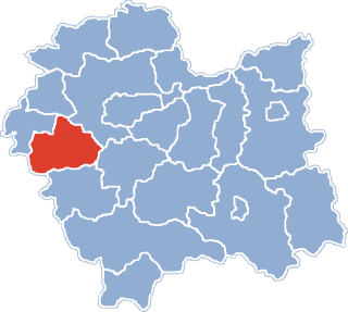
Brzeźnica is a village in Wadowice County, Lesser Poland Voivodeship, in southern Poland. It is the seat of the gmina called Gmina Brzeźnica. It lies approximately 14 kilometres (9 mi) north-east of Wadowice and 25 km (16 mi) south-west of the regional capital Kraków.
Marcyporęba is a village in the administrative district of Gmina Brzeźnica, within Wadowice County, Lesser Poland Voivodeship, in southern Poland. It lies approximately 3 kilometres (2 mi) south-west of Brzeźnica, 12 km (7 mi) north-east of Wadowice, and 27 km (17 mi) south-west of the regional capital Kraków.
Sosnowice is a village in the administrative district of Gmina Brzeźnica, within Wadowice County, Lesser Poland Voivodeship, in southern Poland. It lies approximately 7 kilometres (4 mi) east of Brzeźnica, 18 km (11 mi) north-east of Wadowice, and 21 km (13 mi) south-west of the regional capital Kraków.
Leńcze is a village in the administrative district of Gmina Kalwaria Zebrzydowska, within Wadowice County, Lesser Poland Voivodeship, in southern Poland. It lies approximately 5 kilometres (3 mi) north-east of Kalwaria Zebrzydowska, 16 km (10 mi) east of Wadowice, and 24 km (15 mi) south-west of the regional capital Kraków.
Podolany is a village in the administrative district of Gmina Kalwaria Zebrzydowska, within Wadowice County, Lesser Poland Voivodeship, in southern Poland. It lies approximately 9 kilometres (6 mi) north-east of Kalwaria Zebrzydowska, 20 km (12 mi) east of Wadowice, and 21 km (13 mi) south-west of the regional capital Kraków.
Jastrzębia is a village in the administrative district of Gmina Lanckorona, within Wadowice County, Lesser Poland Voivodeship, in southern Poland. It lies approximately 5 kilometres (3 mi) north-east of Lanckorona, 20 km (12 mi) east of Wadowice, and 25 km (16 mi) south-west of the regional capital Kraków.

Jaszczurowa is a village in the administrative district of Gmina Mucharz, within Wadowice County, Lesser Poland Voivodeship, in southern Poland. It lies approximately 9 kilometres (6 mi) south-east of Wadowice and 39 km (24 mi) south-west of the regional capital Kraków.
Koziniec is a village in the administrative district of Gmina Mucharz, within Wadowice County, Lesser Poland Voivodeship, in southern Poland. It lies approximately 5 kilometres (3 mi) north-west of Mucharz, 6 km (4 mi) south of Wadowice, and 41 km (25 mi) south-west of the regional capital Kraków.

Mucharz is a village in Wadowice County, Lesser Poland Voivodeship, in southern Poland. It is the seat of the gmina called Gmina Mucharz. It lies approximately 9 kilometres (6 mi) south-east of Wadowice and 39 km (24 mi) south-west of the regional capital Kraków.
Zagórze is a village in the administrative district of Gmina Mucharz, within Wadowice County, Lesser Poland Voivodeship, in southern Poland. It lies approximately 3 kilometres (2 mi) north-east of Mucharz, 8 km (5 mi) south-east of Wadowice, and 37 km (23 mi) south-west of the regional capital Kraków.
Dąbrówka is a village in the administrative district of Gmina Stryszów, within Wadowice County, Lesser Poland Voivodeship, in southern Poland.
Stronie is a village in the administrative district of Gmina Stryszów, within Wadowice County, Lesser Poland Voivodeship, in southern Poland. It lies approximately 4 kilometres (2 mi) east of Stryszów, 14 km (9 mi) south-east of Wadowice, and 32 km (20 mi) south-west of the regional capital Kraków.
Lgota is a village in the administrative district of Gmina Tomice, within Wadowice County, Lesser Poland Voivodeship, in southern Poland. It lies approximately 7 kilometres (4 mi) north-east of Tomice, 8 km (5 mi) north-east of Wadowice, and 31 km (19 mi) south-west of the regional capital Kraków.
Witanowice is a village in the administrative district of Gmina Tomice, within Wadowice County, Lesser Poland Voivodeship, in southern Poland. It lies approximately 6 kilometres (4 mi) north-east of Tomice, 7 km (4 mi) north-east of Wadowice, and 32 km (20 mi) south-west of the regional capital Kraków.
Komory is a village in the administrative district of Gmina Korytnica, within Węgrów County, Masovian Voivodeship, in east-central Poland. It lies approximately 3 kilometres (2 mi) north-west of Korytnica, 13 km (8 mi) west of Węgrów, and 62 km (39 mi) north-east of Warsaw.
Wysoka is a village in the administrative district of Gmina Olesno, within Olesno County, Opole Voivodeship, in south-western Poland. It lies approximately 5 kilometres (3 mi) south of Olesno and 40 km (25 mi) north-east of the regional capital Opole.
Lipowo is a village in the administrative district of Gmina Ostróda, within Ostróda County, Warmian-Masurian Voivodeship, in northern Poland. It lies approximately 15 kilometres (9 mi) south-west of Ostróda and 49 km (30 mi) south-west of the regional capital Olsztyn.