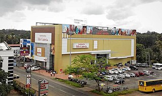
Meenachil is the north-eastern region of Kottayam district in Kerala, south India. The name originates from Meenakshi, the Hindu Goddess. Pala is the main city in Meenachil. The arterial river of the district is also named Meenachil.

Thodupuzha is a municipality and Taluka in the Idukki district of Kerala, India. It is located 55 km (34.2 mi) west of the district headquarters in Painavu and about 192 km (119.3 mi) north of the state capital Thiruvananthapuram. As per the 2011 Indian census, Thodupuzha has a population of 52,045 people, and a population density of 1,468/km2 (3,800/sq mi).

Vaikom is a municipality in the Kottayam district of Kerala, India. It is located 33 km (20.5 mi) north of the district headquarters in Kottayam and about 152 km (94.4 mi) north of the state capital Thiruvananthapuram. As per the 2011 Indian census, Vaikom has a population of 23,234 people, and a population density of 2,661/km2 (6,890/sq mi).

Muvattupuzha is a municipality in the Ernakulam district of Kerala, India. It is located 26 km (16.2 mi) east of the district headquarters in Thrikkakara and about 170 km (105.6 mi) north of the state capital Thiruvananthapuram. As per the 2011 Indian census, Muvattupuzha has a population of 30,397 people, and a population density of 2,306/km2 (5,970/sq mi).
Mundakayam, is a town in Kanjirappally Taluk in the Kottayam District of Kerala. It is the doorway to the high ranges of southern Kerala, and is at the border of Kottayam and Idukki districts. The next nearest town, Kanjirappally, is 14 km (8.7 mi) & Erumely is 12 km from Mundakayam. Mundakayam has rubber plantations, and greenery. The Manimala River runs through Mundakayam. It is located 48 km east of the district headquarters at Kottayam and 148 km from the state capital, Thiruvananthapuram. The name Mundakayam is said to be derived from the Mundi cranes that used to be seen along the Manimala River banks.

Vembanad is the longest lake in India, as well as the largest in the state of Kerala. The lake has an area of 230 square kilometers and a maximum length of 89.5 km.

Ettumanoor is a municipality in the Kottayam district of Kerala, India. It is located 10 km (6.2 mi) north of the district headquarters in Kottayam and about 129 km (80.2 mi) north of the state capital Thiruvananthapuram. As per the 2011 Indian census, Ettumanoor has a population of 26,993 people, and a population density of 1,687/km2 (4,370/sq mi).

Mattanur or Mattannur is a City and largest airport in kannur district.

Uzhavoor is an expanding town in Kottayam district, Kerala in India. It is just 32 km away from the administrative capital Kottayam District. Most of its residents are either wealthy farmers or businessmen. Many of the houses belong to NRIs. The tenth President of India, K. R. Narayanan, was born and brought up in this village. The newly expanded road which connects the city of Pala and other destinations such as Sabarimala to the city of Muvattupuzha passes through Uzhavoor. The town is 177 km from the state capital Thiruvananthapuram.
Kanakkary is a small village in Kottayam district of Kerala state, India. The name Kanakkary is attributed to a lady who frequently visited the village to collect Kanam in the pre-historic times.
The Main Central Road popularly known as MC Road is the arterial State Highway starting from Kesavadasapuram in Trivandrum city and ends at Angamaly, a suburb of Kochi city in Ernakulam District, in the state of Kerala, India. It is designated as State Highway 1 by the Kerala Public Works Department. The highway was built by Raja Kesavadas, Dewan of Travancore, in the 1790s. Plan for a new highway called Thiruvananthapuram–Angamaly Greenfield Highway, which runs parallel to the MC Road is proposed and is under early stage of development.

Nedumkunnam is a village in Kerala, India, located about 16 km East of Changanacherry on Changanacherry-Manimala Road, in Kottayam district. It is 3 km East of Karukachal towards Manimala/Cheruvally.

Punnavely is a village in Thiruvalla Constituency situated on the border of Pathanamthitta and Kottayam districts of Kerala, India. Punnavely is a typical Central Tranvancore village with rubber tree plantations, paddy fields, pepper and other spices and lot of NRIs.
Kadaplamattom is a small village near Palai, Kottayam District, Kerala, India. It is a largely agrarian community, with most of the population having agricultural roles within it. The main crops produced are rubber, coconut, plantain, pepper, and ginger.

Bharanikkavu is a Panchayat in Kayamkulam legislative assembly in Alappuzha district in the Indian state of Kerala.

Kannavam is a Forest in Thalassery Taluk in Kannur District of Kerala State, India. It comes under Chittaripparamba Panchayat. It is located 37 km (23 mi) south east of District headquarters Kannur, 13 km (8.1 mi) east of Kuthuparamba and 466 km (290 mi) from State capital Thiruvananthapuram

Vechoor is a village in Vaikom taluk, Kottayam district in the state of Kerala, India. Vechoor is a short drive away from one of Kerala's tourist destinations, Kumarakom. The Vechur Cow breed of cattle is named after this village.

The SH-07 / T.K.Road is the life line of the Central Travancore.
Koodalloor is a village in Kottayam district, Kerala, India. It is strategically located 7 Kilometers off from Ettumanoor - Pala Road, 2 km from Kadaplamttom 24 km from Kottayam town. It has paddy fields, natural rubber plantations and other agricultural products. Kodalloor is blessed with a popular market, St Joseph's Church, St. Joseph's LP school under Pala diocese, St. Mary's Church and St. Joseph UP School under Kottayam diocese.A Community Health Centre located near Koodalloor-Vayala road caters to the out-patient & in-patient needs of the population

National Highway 183A, also known as NH 183A, is a National Highway in the Indian state of Kerala that runs from Chavara Titanium Junction, Kollam, to Vandiperiyar via Adoor and Pathanamthitta. It is the 4th National Highway passing through the Kollam district.


