Sakot is a small town in Achham District in the Seti Zone of western Nepal. At the time of the 1991 Nepal census, the town had a population of 5195 living in 1113 houses. At the time of the 2001 Nepal census, the population was 5843, of which 24% was literate.
Devisthan is a village development committee in Baglung District in the Dhaulagiri Zone of central Nepal. At the time of the 1991 Nepal census it had a population of 6,151 and had 1247 houses in the town.
Deulek is a village development committee in Baitadi District in the Mahakali Zone of western Nepal. At the time of the 1991 Nepal census it had a population of 2,004 and had 354 houses in the village.
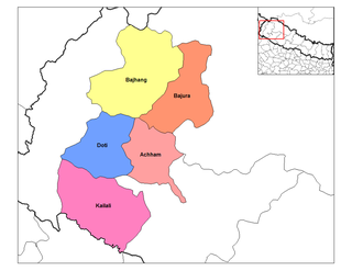
Deulekh is a village in Bajhang District in the Seti Zone of north-western Nepal. At the time of the 1991 Nepal census it had a population of 2,952 and had 456 houses in the village.
Majhigaun is a village in Bajhang District in the Seti Zone of north-western Nepal. At the time of the 1991 Nepal census it had a population of 3,309 and had 622 houses in the village.
Indrapur is a town in Banke District in the Bheri Zone of south-western Nepal. At the time of the 1991 Nepal census it had a population of 5,403 and had 1056 houses in the town. It had been a part of Nepalgunj sub-metropolitan city while expansion of municipality in to sub metropolitan city. However, this part of Sub-metropolitan city was structured under Janaki Rural Municipality.
Titahiriya is a village development committee in Banke District in the Bheri Zone of south-western Nepal. At the time of the 1991 Nepal census it had a population of 6,986 and had 970 houses in the town.
Harbhi is a village development committee in Gorkha District in the Gandaki Zone of northern-central Nepal. At the time of the 1991 Nepal census it had a population of 3,910 and had 754 houses in the town.
Bhumidanda is a village development committee in Kabhrepalanchok District in the Bagmati Zone of central Nepal. At the time of the 1991 Nepal census it had a population of 3383 and had 630 houses in it.
Khopasi is a village development committee in Kabhrepalanchok District in the Bagmati Zone of central Nepal. At the time of the 1991 Nepal census it had a population of 3453 in 676 individual households.
Sunthan is a village development committee in Kabhrepalanchok District in the Bagmati Zone of central Nepal. At the time of the 1991 Nepal census it had a population of 3491 in 650 individual households.
Singasain is a village development committee in Dailekh District in the Bheri Zone of western-central Nepal. At the time of the 1991 Nepal census it had a population of 3702 people living in 692 individual households.
Khanikhola is a village development committee in Surkhet District in the Bheri Zone of mid-western Nepal. At the time of the 1991 Nepal census it had a population of 3127 people living in 512 individual households.
Kadamandau is a village development committee in Doti District in the Seti Zone of western Nepal. At the time of the 1991 Nepal census it had a population of 3084 living in 609 individual households.
Pokhari is a Village Development Committee in Doti District in the Seti Zone of western Nepal. At the time of the 1991 Nepal census it had a population of 2968 residing in 632 individual households.
Santpur is a town and market center in Chandrapur Municipality in Rautahat District in the Narayani Zone of south-eastern Nepal. The formerly village development committee was merged to form the municipality on 18 May 2014. At the time of the 1991 Nepal census it had a population of 5594.
Tarkulaha is a village development committee in Rupandehi District in the Lumbini Zone of Southern Nepal. At the time of the 1991 Nepal census it had a population of 3290 people living in 533 individual households.
Barangdi is a village development committee in Palpa District in the Lumbini Zone of southern Nepal. At the time of the 1991 Nepal census it had a population of 2475 people living in 470 individual households.
Kushawa is a village development committee in Kapilvastu District in the Lumbini Zone of southern Nepal. At the time of the 1991 Nepal census it had a population of 3586 people living in 578 individual households.
Nanda Nagar is a village development committee in Kapilvastu District in the Lumbini Zone of southern Nepal. At the time of the 1991 Nepal census it had a population of 4740 people living in 808 individual households.