
Kamehameha I, also known as Kamehameha the Great, was the conqueror and first ruler of the Kingdom of Hawaii. The state of Hawaii gave a statue of him to the National Statuary Hall Collection in Washington, D.C., as one of two statues it is entitled to install there.

Kihei is a census-designated place (CDP) in Maui County, Hawaii, United States. The population was 21,423 at the 2020 census.
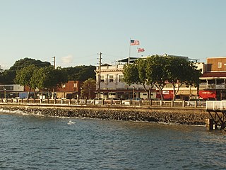
Lahaina is a census-designated place (CDP) in Maui County, Hawaii, United States. On the northwest coast of the island of Maui, it encompasses Lahaina town and the Kaanapali and Kapalua beach resorts. At the 2020 census, Lahaina had a resident population of 12,702. The CDP spans the coast along Hawaii Route 30 from a tunnel at the south end, through Olowalu, and to the CDPs of Kaanapali and Napili-Honokowai to the north.

Kalanikauikaʻalaneo Kai Keōpūolani-Ahu-i-Kekai-Makuahine-a-Kama-Kalani-Kau-i-Kealaneo (1778–1823) was a queen consort of Hawaiʻi and the highest ranking wife of King Kamehameha I.
The Lahaina Civic Center is a sports, convention and entertainment complex located at Ka'a'ahi Street and Honoapi'ilani Highway in Lahaina, Hawaii, on the island of Maui. It is the site of the annual Maui Invitational Basketball Tournament, held every November during Thanksgiving week and hosted by Chaminade University located in Hawaii. Other events include the World Youth Basketball Tournament in July, concerts, trade shows, community festivals and fairs.

The Battle of Kepaniwai was fought in 1790 between the islands of Hawaiʻi and Maui. The forces of Hawaiʻi were led by Kamehameha I, while the forces of Maui were led by Kalanikūpule. It is known as one of the most bitter battles fought in Hawaiian history.

Puʻunēnē is an unincorporated community in the central part of Maui, Hawaii, United States, with a population of approximately 50. Although the land is fairly level, the Hawaiian name for the area means "goose hill", in reference to the endemic nēnē.
Lahainaluna High School is a public high school with the grades 9-12 located in Lahaina. Lahainaluna High School is also a public boarding school. It was founded in 1831 as a Protestant missionary school, originally named Lahainaluna Seminary. The early missionaries who arrived in Lahaina in 1823 explained to the Hawaiian Royalty the importance of an educational institution in the American style.
The Battle of Nuʻuanu, fought in May 1795 on the southern part of the island of Oʻahu, was a key battle in the final days of King Kamehameha I's wars to conquer the Hawaiian Islands. It is known in the Hawaiian language as Kalelekaʻanae, which means "the leaping mullet", and refers to a number of Oʻahu warriors driven off the cliff in the final phase of the battle. There are "varied and sometimes conflicting histories of the Battle of Nuʻuanu."

Honolua Bay, Mokuleʻia Bay and Lipoa Point are part of an area known as the ahupuaʻa of Honolua, located just north of Kapalua, West Maui in Maui County, Hawaiʻi, United States. The area is a mix of agricultural and conservation land tended by the Maui Land & Pineapple Company in Lahaina, Hawaiʻi, including coastline management. Honolua Bay and Mokuleʻia Bay comprise the 45-acre (18 ha) Honolua-Mokuleʻia Marine Life Conservation District.
Kalanikūpule was the Mōʻī of Maui and King of Oʻahu. He was the last king to engage in combat with Kamehameha I over the Hawaiian Islands. Kalanikūpule was the last of the longest line of aliʻi nui in the Hawaiian Islands. In Hawaiian his name means "the heavenly prayer of Kū".

Kaunolū Village Site is located on the south coast of the island of Lānaʻi. This former fishing village, abandoned in the 1880s, is the largest surviving ruins of a prehistoric Hawaiian village. The archaeological site is very well preserved and covers almost every phase of Hawaiian culture. It was designated a U.S. National Historic Landmark in 1962 and added to the National Register of Historic Places in 1966.
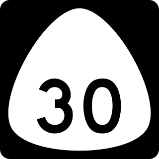
Hawaii Route 30, also known as the Honoapiʻilani Highway, is a 35-mile-long (56 km) road on West Maui, Hawaii. It begins in downtown Wailuku, extending south through Waikapu and Maalaea. The Olowalu Tunnel, located at mile 10.4, is 318 feet (97 m) long.

Kaumahina State Wayside Park or Kaumahina State Park, is located in Maui County, Hawaii, 28.3 miles (45.5 km) East of Kahului and 22.4 miles (36.0 km) West of Hana along the Hana Highway. The park consists of 7.8 acres (32,000 m2) of forest and exotic plants. Amenities include a rest stop and scenic views of the northeast Maui coastline and Ke'anae Peninsula.
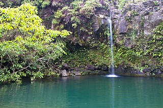
Puaʻa Kaʻa State Wayside Park is a state park on the island of Maui, Hawaiʻi. It is located along the Hana Highway approximately 39 mi (63 km) east of Kahului. The area consists of 5 acres (2.0 ha) of rainforest with waterfalls and pools. The park is at an elevation of 1,200 ft (370 m) and roughly 0.5 mi (0.80 km) away from Waiohue Bay.
Olowalu is a community on the west side of the island of Maui in the state of Hawaii. It is located about 4 miles (6 km) south of Lahaina on the Honoapiʻilani Highway. It is a census-designated place (CDP), with a population at the 2020 census of 100.

Kaanapali Airport was a small regional airport located on the northwest end of Maui, near the city of Lahaina and north of Kaanapali Beach in Honokōwai. The airport serviced West Maui between 1965 and its closure in 1986.

The East Molokai Volcano, sometimes also known as Wailau for the Wailau valley on its north side, is an extinct shield volcano comprising the eastern two-thirds of the island of Molokaʻi in the U.S. state of Hawaii.
The Spirit of Aloha Oceanfront Botanical Gardens also referred to as The Gardens, is an 11-acre nature preserve located just off the Hana Highway on in Haiku, Hawaii on the island of Maui. It overlooks Ua'oa Bay in the Pacific Ocean and Papanui o Kane Hawaiian island. The historic was originally granted by a Land Commission Award by the Kingdom of Hawaii Department of the Interior in 1848.

