
Nānāwale Estates is a census-designated place (CDP) in Hawaiʻi County, Hawaii, United States located in the District of Puna. The population was 1,426 at the 2010 census, up from 1,073 at the 2000 census.

Haiku-Pauwela is a census-designated place (CDP) in Maui County, Hawaii, United States, consisting of the village of Haiku, Hawaii and the hamlet of Pauwela. Haiku itself is an unincorporated community. The population was 8,595 at the 2020 census.

Haliimaile is a census-designated place (CDP) in Maui County, Hawaii, United States. The population was 1,074 at the 2020 census.

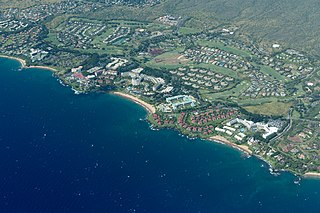
Kapalua is a census-designated place (CDP) in Maui County, Hawaiʻi, United States. A resort development by the Maui Land & Pineapple Company extends inland from Kapalua Bay and Honolua Bay. The population was 495 at the 2020 census.

Kihei is a census-designated place (CDP) in Maui County, Hawaii, United States. The population was 21,423 at the 2020 census.

Mā'alaea is a census-designated place (CDP) in Maui County, Hawaii, United States. The population was 310 at the 2020 census. Mā‘alaea sits on the southern coast of the isthmus separating West Maui from the island’s Central Valley. Like other ahupua‘a, it widens as it descends from mountain slopes into the sea, occupying 5.4 square miles of land and 2.3 miles of ocean. For more than a millennium, Mā‘alaea has been a crossroads, a landing place for Hawaiian kings and armies, and in time, whalers and sailing ships. Highways follow the ancient trails that once branched north to Wailuku, west to Lahaina, and south to what are now the towns of Kīhei and Wailea. The name Mā‘alaea comes from the Hawaiian word ‘alae, the iron oxide from volcanic eruptions that gives the region its iron-rich red earth.

Makawao is a census-designated place (CDP) in Maui County, Hawaiʻi, United States. The population was 7,297 at the 2020 census. Located on the rural northwest slope of Haleakalā, the community is known for being the hub of Upcountry Maui, a part of the island dominated by mostly agriculture and ranch land. Makawao Forest Reserve is to the east-northeast.

Napili-Honokowai is a census-designated place (CDP) in Maui County, Hawaii, United States. The population was 7,042 at the 2020 census.

Pā'ia is a census-designated place (CDP) in Maui County, Hawaii, United States, on the northern coast of the island of Maui. The population was 2,470 at the 2020 census. Pā'ia is home to several restaurants, art galleries, surf shops and other tourist-oriented businesses. It was formerly home to a Hawaiian Commercial & Sugar mill from 1880 to 2000.

Pukalani is a census-designated place (CDP) in Maui County, Hawaiʻi, United States. The population was 8,299 at the 2020 census. The western volcano-slope region of Haleakalā, including nearby Makawao and Kula, is referred to as Upcountry Maui by locals, and is one of the four major population centers on Maui.

Waihee-Waiehu is a census-designated place (CDP) in Maui County, Hawaii, United States. The population was 9,234 at the 2020 census.
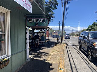
Waikapu is a census-designated place (CDP) in Maui County, Hawaii, United States. The population was 3,437 at the 2020 census.
Wailea-Makena was a census-designated place (CDP) in Maui County, Hawaiʻi, United States, during the 2000 census, at which time its population was 5,671. The area was split into two CDPs, Wailea and Makena, for the 2010 census.
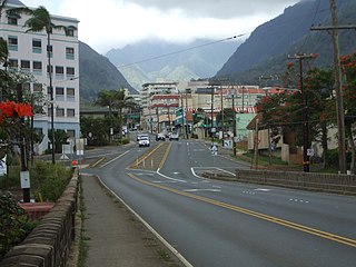
Wailuku is a census-designated place (CDP) in and county seat of Maui Island, Maui County, Hawaii, United States. The population was 17,697 at the 2020 census.

Keokea is an unincorporated community, census-designated place (CDP), and Hawaiian home land on the island of Maui in Maui County, Hawaii, United States. It is situated on Hawaii State Highway 37 at North Latitude 20.71 degrees, West Longitude 156.36 degrees. Its elevation is 2,860 feet above sea level. As of the 2020 census its population was 2,199, up from 1,612 in 2010.
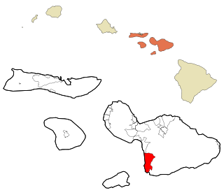
Wailea is a census-designated place (CDP) in Maui County, Hawaii, United States. As of the 2020 census, it had a population of 6,027. Prior to 2010, the area was part of the Wailea-Makena census-designated place. The community was developed in 1971 by a partnership of Alexander & Baldwin and Northwestern Mutual.

Makena is a census-designated place (CDP) in the extreme southwest of the island of Maui in Maui County, Hawaiʻi, United States. As of the 2020 census, it had a population of 196, up from 99 in 2010. Prior to 2010, the area was part of the Wailea-Makena census-designated place.
Discovery Harbour is an unincorporated community and census-designated place on the island of Hawaii in Hawaii County, Hawaii, United States. Its population was 1,171 as of the 2020 census. The community is located near the island's southern tip, south of Hawaii Route 11. It is the southernmost populated place in the 50 states of the U.S., surpassing Naalehu by 5.4 miles (8.7 km).

Launiupoko is an unincorporated community and census-designated place on the island of Maui in Maui County, Hawaii, United States. It is located on the west side of the island, along the coast between Lahaina to the immediate north and Olowalu slightly to the south. Its population was 688 as of the 2020 census.

Ualapue is an unincorporated community, census-designated place, and Hawaiian home land on the island of Molokaʻi in Maui County, Hawaii, United States. Its population was 393 as of the 2020 census. The community is located along Hawaii Route 450 on the southeast coast of the island of Molokaʻi. Ualapue does not have villages, but many famous fishponds.

