Wailea, Hawaii

Last updated

Wailea, Hawaii
Wailea, HI.jpg
Coordinates: 20°41′24″N156°26′21″W / 20.69000°N 156.43917°W / 20.69000; -156.43917
Country United States
State Hawaii
County Maui
Area
[1]
  Total10.74 sq mi (27.82 km2)
  Land7.44 sq mi (19.28 km2)
  Water3.30 sq mi (8.54 km2)
Population
 (2020)
  Total6,027
  Density809.65/sq mi (312.59/km2)
Time zone UTC-10 (Hawaii-Aleutian)
Area code 808
FIPS code 15-76935

Wailea is a census-designated place (CDP) in Maui County, Hawaii, United States. As of the 2020 census, it had a population of 6,027. [2] Prior to 2010, the area was part of the Wailea-Makena census-designated place. The community was developed in 1971 by a partnership of Alexander & Baldwin and Northwestern Mutual. [3]

Contents

Geography

Wailea is located at 20°41′24″N156°26′21″W / 20.69000°N 156.43917°W / 20.69000; -156.43917 (20.690104, -156.439108). [4]

According to the United States Census Bureau, the CDP covers an area of 10.7 square miles (27.8 km2), of which 7.5 square miles (19.3 km2) is land and 3.3 square miles (8.5 km2), or 30.70%, is water. [5]

Wailea is bordered by Makena to the south, Kihei to the north, the Pacific to the west and Haleakalā to the east.

Wailea has multiple beaches, including Polo, [6] Wailea, [7] Ulua, [8] Mokapu, [9] and Keawakapu. [10]

Demographics

Historical population
CensusPop.Note
2020 6,027
U.S. Decennial Census [2]

Resorts

Wailea Resort is a 1,500-acre (6.1 km2), master-planned resort located on Maui's sunny, southern leeward coast. Its development is guided by two important documents: a master plan that ostensibly ensures low density and good community planning, and the Wailea Community Association's design guidelines which claim to preserve Maui's island environment in all new building projects. [11] Both documents are administered by the Wailea Community Association, which has long combined professional management (since 1984) and volunteer owner control of the Board of Directors (since 1999) to effectively manage the community in a customer service manner for all stakeholders: residents, hotels, commercial owners, and tourists. Wailea was named one of the country's 99 Best Recreational & Residential Private Communities in America. Many of Wailea's single-family and condominium complexes offer gated entryways for enhanced security and privacy. Utilities are buried underground, and roadways are landscaped. Nearby are Wailea's many amenities, including restaurants, championship golf courses, tennis facilities, shopping, and beaches.

Panoramic view of Wailea Beach from water 20190216P2160161-Pano.jpg
Panoramic view of Wailea Beach from water
Wailea beach resort, Maui, Hawaii Wailea beach resort Maui, Hawaii (30800178817).jpg
Wailea beach resort, Maui, Hawaii

Economy

Major employers in Wailea include the Grand Wailea Resort, Four Seasons Resort Maui, Fairmont Kea Lani, Marriott Wailea Beach, the Wailea Golf Club, Wailea Beach Villas, Tommy Bahama, Spago, Polo Beach Club, Wailea Grand Champions, and Destination Residences Hawaii. [12]

History

Wailea was originally a fishing settlement and its name translates to “water of lea”  the goddess of canoe-builders. Legend has it she transformed the area into a beautiful forest for birds and would frequently fly above it to appreciate its beauty. In ancient Hawaiian times natives would settle toward the mountains of Wailea where they grew sweet potatoes (uala) and would venture down to the shore to fish.

In the past two centuries cattle raising became a mainstay of the economy and led to the formation of places such as Ulupalakua Ranch.

See also

Sunset in Wailea Sunset in Wailea.jpg
Sunset in Wailea

Related Research Articles

<span class="mw-page-title-main">Maui</span> Second-largest of the Hawaiian Islands

The island of Maui is an island in the Hawaiian archipelago, its second-largest at 727.2 square miles (1,883 km2). It is the 17th-largest in the United States. Maui is one of Maui County's five islands, along with Molokaʻi, Lānaʻi, Kahoʻolawe, and Molokini.

<span class="mw-page-title-main">Maui County, Hawaii</span> County in Hawaii, United States

Maui County, officially the County of Maui, is a county in the U.S. state of Hawaii. It consists of the islands of Maui, Lānaʻi, Molokaʻi, Kahoʻolawe, and Molokini. The latter two are uninhabited. As of the 2020 census, the population was 164,754. The county seat is Wailuku.

<span class="mw-page-title-main">Kailua, Hawaii</span> Census-designated place in Hawaii, United States

Kailua is a census-designated place (CDP) in Honolulu County, Hawaii, United States. It lies in the Koʻolaupoko District of the island of Oʻahu on the windward coast at Kailua Bay. It is in the judicial district and the ahupua'a named Ko'olaupoko. It is 12 miles (19 km) northeast of Honolulu – over Nu‘uanu Pali.

<span class="mw-page-title-main">Kaanapali, Hawaii</span> Census-designated place in Hawaii, United States

Kaanapali is a planned resort community in Maui County, Hawaii, United States, on the island of Maui located in the Old Hawaii ahupuaa of Hanakaʻōʻō, as in the same name of the southern end of Kaanapali Beach's Hanakaʻōʻō Canoe Beach. The population was 1,161 at the 2020 census. For statistical purposes, the United States Census Bureau has defined Kaanapali as a census-designated place (CDP).

<span class="mw-page-title-main">Kapalua, Hawaii</span> Census-designated place in Hawaii, United States

Kapalua is a census-designated place (CDP) in Maui County, Hawaiʻi, United States. A resort development by the Maui Land & Pineapple Company extends inland from Kapalua Bay and Honolua Bay. The population was 495 at the 2020 census.

<span class="mw-page-title-main">Kihei, Hawaii</span> Census-designated place in Hawaii, United States

Kihei is a census-designated place (CDP) in Maui County, Hawaii, United States. The population was 21,423 at the 2020 census.

<span class="mw-page-title-main">Maalaea, Hawaii</span> Census-designated place in Hawaii, United States

Mā'alaea is a census-designated place (CDP) in Maui County, Hawaii, United States. The population was 310 at the 2020 census. Mā‘alaea sits on the southern coast of the isthmus separating West Maui from the island’s Central Valley. Like other ahupua‘a, it widens as it descends from mountain slopes into the sea, occupying 5.4 square miles of land and 2.3 miles of ocean. For more than a millennium, Mā‘alaea has been a crossroads, a landing place for Hawaiian kings and armies, and in time, whalers and sailing ships. Highways follow the ancient trails that once branched north to Wailuku, west to Lahaina, and south to what are now the towns of Kīhei and Wailea. The name Mā‘alaea comes from the Hawaiian word ‘alae, the iron oxide from volcanic eruptions that gives the region its iron-rich red earth.

<span class="mw-page-title-main">Napili-Honokowai, Hawaii</span> Census-designated place in Hawaii, United States

Napili-Honokowai is a census-designated place (CDP) in Maui County, Hawaii, United States. The population was 7,042 at the 2020 census.

<span class="mw-page-title-main">Paia, Hawaii</span> Census-designated place in Hawaii, United States

Pā'ia is a census-designated place (CDP) in Maui County, Hawaii, United States, on the northern coast of the island of Maui. The population was 2,470 at the 2020 census. Pā'ia is home to several restaurants, art galleries, surf shops and other tourist-oriented businesses. It was formerly home to a Hawaiian Commercial & Sugar mill from 1880 to 2000.

<span class="mw-page-title-main">Pukalani, Hawaii</span> Census-designated place in Hawaii, United States

Pukalani is a census-designated place (CDP) in Maui County, Hawaiʻi, United States. The population was 8,299 at the 2020 census. The western volcano-slope region of Haleakalā, including nearby Makawao and Kula, is referred to as Upcountry Maui by locals, and is one of the four major population centers on Maui.

<span class="mw-page-title-main">Wailea-Makena, Hawaii</span> Former CDP in Hawaii, United States

Wailea-Makena was a census-designated place (CDP) in Maui County, Hawaiʻi, United States, during the 2000 census, at which time its population was 5,671. The area was split into two CDPs, Wailea and Makena, for the 2010 census.

<span class="mw-page-title-main">Wailuku, Hawaii</span> Census-designated place in Hawaii, United States

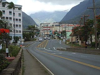
Wailuku is a census-designated place (CDP) in and county seat of Maui Island, Maui County, Hawaii, United States. The population was 17,697 at the 2020 census.

Kula is a district and census-designated place (CDP) of Maui, Hawaii. It stretches across Upcountry Maui, the western-facing slopes of Haleakalā. Most residential areas lie between about 500 to 1,100 m in elevation. The district is distinct from the generally hotter and busier coastal areas. The population of the Kula CDP at the 2020 Census was 6,942, while the larger Kula Census County Division, which includes the communities of upland Keokea and coastal Wailea and Makena, had a population of 12,864.

<span class="mw-page-title-main">Makena State Park</span> State park in Makena, Maui Island, Hawaii, United States

Mākena State Park is a 165-acre (0.7 km2) beachside park in Makena on the island of Maui, Hawaii. Located just south of Wailea, it contains three separate beaches and a dormant volcanic cinder cone.

The South Maui Coastal Heritage Corridor is a recreation and tourism project of the Tri-Isle Resource Conservation and Development Council. The non-profit council partners with the Natural Resources Conservation Service of the United States Department of Agriculture. The project is managed by a committee chairperson in cooperation with the Hawaii Department of Land and Natural Resources, Division of Forestry and Wildlife, Na Ala Hele Trails and Access Program, U.S. Fish and Wildlife Service, University of Hawaii, Sea Grant Extension Service, and individuals from the community of Kihei. The project protects and provides public access to South Maui's 15 mile leeward coastline.

<span class="mw-page-title-main">Hawaii Route 31</span> State highway in Hawaii, United States

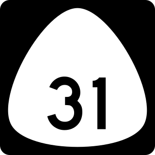
Hawaii Route 31, also known as the Pi'ilani Highway, is a 38-mile road on the island of Maui in Maui County, Hawaii, United States.

<span class="mw-page-title-main">Makena, Hawaii</span> Census-designated place in Hawaii, United States

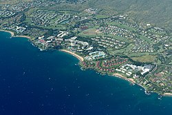
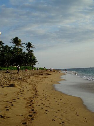
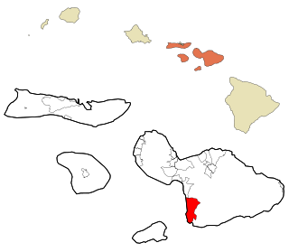
Makena is a census-designated place (CDP) in the extreme southwest of the island of Maui in Maui County, Hawaiʻi, United States. As of the 2020 census, it had a population of 196, up from 99 in 2010. Prior to 2010, the area was part of the Wailea-Makena census-designated place.

<span class="mw-page-title-main">Golf clubs and courses in Hawaii</span>

There are 75 golf courses in Hawaii.

<span class="mw-page-title-main">Makena Beach & Golf Resort</span> Building in Makena district, next to Wailea

Makena Beach & Golf Resort Maui was a beach and golf resort in the Makena district, on the southern shore of Maui County, Hawaiʻi, United States. The resort was formerly known as the Maui Prince Hotel, and was designed by Anbe, Aruga, and Ishizu architects. It was opened in August 1986 and subsequently sold in July 2010 to AREA Property Partners. It had several hundred rooms and suites leading to an open-air atrium and outdoor pools built around an Asian meditation garden with waterfalls.

The 2014 Junior Pan Pacific Swimming Championships were held from 27 to 31 August 2014 in Maui, Hawaii, United States. Pool competition was conducted in a long course pool at Kihei Aquatic Center in Kihei, Hawaii and the open water marathons were contested at Ulua Beach in Wailea, Hawaii.

References

  1. "2020 U.S. Gazetteer Files". United States Census Bureau. Retrieved December 18, 2021.
  2. 1 2 "Census of Population and Housing". Census.gov. Retrieved June 4, 2016.
  3. "History & Culture of Wailea". Wailea Resort Association. Retrieved April 22, 2018.
  4. "US Gazetteer files: 2010, 2000, and 1990". United States Census Bureau. February 12, 2011. Retrieved April 23, 2011.
  5. "Geographic Identifiers: 2010 Demographic Profile Data (G001): Wailea CDP, Hawaii". United States Census Bureau . Retrieved December 29, 2011.
  6. Travel, We Dream of (April 17, 2022). "Polo Beach, Maui: The Complete Guide + Photos & Directions". We Dream of Travel Blog. Retrieved December 31, 2022.
  7. "Wailea Beach: One of the Best Maui Beaches". Paradise Found in Maui. Retrieved December 31, 2022.
  8. "Ulua Beach". Maui Guidebook. October 13, 2013. Retrieved December 31, 2022.
  9. "The Maui Expert — Mokapu Beach". The Maui Expert. Retrieved December 31, 2022.
  10. "Keawakapu Beach | Maui Hawaii". www.hawaii-guide.com. Retrieved December 31, 2022.
  11. "Wailea Community Association Rules and Guidelines". Archived from the original on August 4, 2009. Retrieved December 29, 2011.
  12. Search Results - Kihei, Hawaii - ReferenceUSA Current Businesses