
East Africa or Eastern Africa is the eastern region of the African continent, variably defined by geography. In the United Nations Statistics Division scheme of geographic regions, 20 territories make up Eastern Africa:

Tanga is both the name of the most northerly port city of Tanzania on the west of the Indian Ocean, and the surrounding Tanga Region. It is the Regional Headquarters of the region. With a population of 273,332 in 2012, Tanga is one of the largest cities in the country. It is a quiet city compared to, for example, Arusha or Moshi with a comparable number of inhabitants.

Moshi is a municipality and the capital of Kilimanjaro region in the north eastern Tanzania. As of 2017, the municipality has an estimated population of 201,150 and a population density of 3,409 persons per km2. In the last official census of 2012, the municipality had a population of 184,292. The municipality is situated on the lower slopes of Mount Kilimanjaro, a dormant volcano that is the highest mountain in Africa. The municipality covers about 59 square kilometres (23 sq mi) and is the smallest municipality in Tanzania by area.
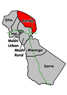
Rombo District is one of the seven districts of the Kilimanjaro Region of Tanzania. It is bordered to the north and east by Kenya, to the west by the Siha District and Hai District, and to the south by the Moshi Rural District.
The East African mountains are a mountain region in the African Great Lakes, within Kenya, Uganda, Tanzania, Democratic Republic of the Congo, Rwanda and Burundi.
The Kahe are an ethnic and linguistic group based southeast of Moshi in Kilimanjaro Region Tanzania. The Kahe language, or Kikahe, is in the Chagga cluster of Bantu languages. Three dialects are recognized: Kimwangaria, Msengoni and Kichangareni. Kikahe is spoken by 9130 people, and is one of the smaller language communities in Tanzania.
The history of rail transport in Tanzania began in the late nineteenth century.

Lake Jipe is an inter-territorial lake straddling the borders of Kenya and Tanzania. On the Kenyan side, it is located south of the village of Nghonji while on the Tanzanian side, it is situated within Mwanga District, in Kilimanjaro Region. The lake is fed mainly by the Lumi River, which descends from Mount Kilimanjaro, as well as streams from the North Pare Mountains, being on the leeward side. The lake's outlet forms the Ruvu River. Kenya's unfenced Tsavo West National Park protects part of the lake's northern shore, while on the Tanzania side Mkomazi Game Reserve is nearby. The lake is known for its endemic fish, as well as water birds, mammals, wetland plants and lake-edge swamps, which can extend 2 kilometres (1.2 mi) from Jipe's shore.
The River Lumi is located in northern Tanzania and southern Kenya in Coast Province. It originates on the east side of Mawenzi, and flows so close to the River Rombo as almost to form a fork. The Lumi, however, maintains its southerly direction, and may thus be said to represent the upper course of the Ruvu, one of tho two main sources of the Pangani River. It flows around the Lake Chala and the Taveta town in the west and empties into the Lake Jipe. The fish species Barbus sp. 'Pangani' has only been found in the river's N'joro Springs, situated in the upper Pangani River drainage basin.

The Pangani River (pin-gi'nee) is a major river of northeastern Tanzania. It has two main sources: the Ruvu, which rises as Lumi at Kilimanjaro, passes through Lake Jipe, and empties into the Nyumba ya Mungu Reservoir, and the Kikuletwa, coming from the west and mainly fed by Mount Meru, which also enters into the Nyumba ya Mungu Reservoir. Just after leaving the reservoir the stream becomes the Pangani, which empties into the Indian Ocean at the town of Pangani.

Himo is a village in the Makuyuni ward of Kilimanjaro Region in Tanzania.
The KUR EC2 class, later known as the EAR 52 class, was a class of 1,000 mm gauge 4-8-2+2-8-4 Garratt-type articulated steam locomotives.
The EAR 29 class was a class of oil-burning 1,000 mm gauge 2-8-2 steam locomotives based upon the Nigerian Railways River class. The 31 members of the 29 class were built for the East African Railways (EAR) in two batches, of 20 and 11 locomotives respectively, by North British Locomotive Company in Glasgow, Scotland.

The EAR 31 class was a class of oil-burning 1,000 mm gauge 2-8-4 steam locomotives. The 46 members of the class were built in 1955 by Vulcan Foundry, in Newton-le-Willows, Lancashire, England, for the East African Railways (EAR). They were a lighter, branch-line version of the EAR 30 class, and worked from various sheds throughout the EAR system.

The TR DL class, later known as the EAR 23 class, was a class of 1,000 mm gauge 4-8-0 steam locomotives derived from the Nigerian Railways Emir class. The six members of the DL/23 class were built by Beyer, Peacock & Co. in Gorton, Manchester, England, for the Tanganyika Railway (TR). They entered service on the TR in 1923, and were later operated by the TR's successor, the East African Railways (EAR).
The TR ML class, later known and expanded as the EAR 26 class, was a class of 1,000 mm gauge 2-8-2 steam locomotives designed for and ordered by the Tanganyika Railway (TR), as a development of the TR MK class.
Arusha–Holili–Taveta–Voi Road (A23) is a road in Tanzania and Kenya, connecting the towns of Arusha, Moshi, and Holili in Tanzania with Taveta and Voi in Kenya.

Holili, is a town in Rombo District, Kilimanjaro Region, in northeastern Tanzania, at the border with Kenya.


