
Dartmouth Dam is a large rock-fill embankment dam with an uncontrolled chute spillway across the Mitta Mitta, Gibbo and Dart rivers, the Morass Creek and a number of small tributaries. The dam is located near Mount Bogong in the north-east of the Australian state of Victoria. The dam's purpose includes irrigation, the generation of hydro-electric power, water supply and conservation. The impounded reservoir is called Dartmouth Reservoir, sometimes called Lake Dartmouth. The Dartmouth Power Station, a hydro-electric power station that generates power to the national grid, is located near the dam wall.

Hydroelectricity, or hydroelectric power, is electricity generated from hydropower. Hydropower supplies 14% of the world's electricity, almost 4,210 TWh in 2023, which is more than all other renewable sources combined and also more than nuclear power. Hydropower can provide large amounts of low-carbon electricity on demand, making it a key element for creating secure and clean electricity supply systems. A hydroelectric power station that has a dam and reservoir is a flexible source, since the amount of electricity produced can be increased or decreased in seconds or minutes in response to varying electricity demand. Once a hydroelectric complex is constructed, it produces no direct waste, and almost always emits considerably less greenhouse gas than fossil fuel-powered energy plants. However, when constructed in lowland rainforest areas, where part of the forest is inundated, substantial amounts of greenhouse gases may be emitted.

The Eildon Dam is a rock and earth-fill embankment dam with a controlled spillway, located on the Goulburn River between the regional towns of Mansfield and Eildon within Lake Eildon National Park, in the Alpine region of Victoria, Australia. The dam's purpose is for the supply of potable water, irrigation, and the generation of hydroelectricity. The impounded reservoir is called Lake Eildon.The first cut of ground was done by Mr Bain and Mr MacLean from Scotland.
The Jalaput Dam is a hydroelectric dam built on the Machkund River, a tributary of the Godavari River in India which rises in the Mudugal hills of Alluri Sitharama Raju district District and nearby Ondra Gadda it becomes the boundary between Andhra Pradesh and Odisha. This Dam is the most ignored one in India, currently, it is in dilapidated condition. For over 48 km the river runs nearly north along a meandering course through the Padwa Valley. About 48 km south of Jeypore, it winds westward along the edge of the Plateau and then suddenly tums at a short angle to the south-west down a steep descent popularly known as Duduma Falls.

Nagarjuna Sagar Dam is a masonry dam across the Krishna River at Nagarjuna Sagar which straddles the border between Palnadu district in Andhra Pradesh and Nalgonda district in Telangana. The dam provides irrigation water to the districts of Krishna, Guntur, Palnadu, Prakasam and parts of West Godavari districts of Andhra Pradesh and also Nalgonda, Suryapet, Khammam, Bhadradri Kothagudem districts of Telangana. It is also a source of electricity generation for the national grid.
Hale Dam is a hydroelectric dam in Tanzania, located in the town of Hale in Mnyuzi ward of Korogwe District of Tanga Region. Its installed capacity is 21 megawatts (28,000 hp). Thousands of people were displaced to build the dam.

Lake Qaraoun is an artificial lake or reservoir located in the southern region of the Beqaa Valley, Lebanon. It was created near Qaraoun village in 1959 by building a 61 m-high (200 ft) concrete-faced rockfill dam in the middle reaches of the Litani River. The reservoir has been used for hydropower generation, domestic water supply, and for irrigation of 27,500 ha.

Ujjani Dam, also known as Bhima Dam or Bhima Irrigation Project, on the Bhima River, a tributary of the Krishna River, is an earthfill cum Masonry gravity dam located near Ujjani village of Madha Taluk in Solapur district of the state of Maharashtra in India.
Sileru River is a tributary of Sabari River in southern India. It originates in Andhra Pradesh and also flows through Odisha before merging with Sabari. Sabari river crosses the border into Andhra Pradesh to merge with Godavari river. Sileru river joins Sabari river tri-junction boundary point of Andhra Pradesh, Chhattisgarh and Odisha.

The Gilgel Gibe III Dam is a 250m high roller-compacted concrete dam with an associated hydroelectric power plant on the Omo River in Ethiopia. It is located about 62 km (39 mi) west of Sodo in the Southern Nations, Nationalities, and Peoples' Region. Once fully commissioned, it will be the third largest hydroelectric plant in Africa with a power output of about 1,870 Megawatt (MW), thus more than doubling Ethiopia's total installed capacity from its 2007 level of 814 MW. The Gibe III dam is part of the Gibe cascade, a series of dams including the existing Gibe I dam and Gibe II power station as well as the planned Gibe IV and Gibe V dams. The existing dams are owned and operated by the state-owned Ethiopian Electric Power, which is also the client for the Gibe III Dam.
Lake Ambussel is a lake on the Lossogonoi Plateau in Tanzania. Along with Nyumba ya Mungu Reservoir, Lake Chala and Lake Jipe, it is one of four waterbodies in the Pangani basin.

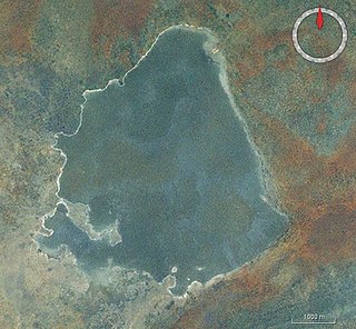
Lake Jipe is an inter-territorial lake straddling the borders of Kenya and Tanzania. On the Kenyan side, it is located south of the village of Nghonji while on the Tanzanian side, it is situated within Mwanga District, in Kilimanjaro Region. The lake is fed mainly by the Lumi River, which descends from Mount Kilimanjaro, as well as streams from the North Pare Mountains, being on the leeward side. The lake's outlet forms the Ruvu River. Kenya's unfenced Tsavo West National Park protects part of the lake's northern shore, while on the Tanzania side Mkomazi Game Reserve is nearby. The lake is known for its endemic fish, as well as water birds, mammals, wetland plants and lake-edge swamps, which can extend 2 kilometres (1.2 mi) from Jipe's shore.
The River Lumi is located in Rombo District, Kilimanjaro in northereast Tanzania and a small part in southern Kenya in Coast Province. It originates on the east side of Mawenzi peak on the east side of, and flows so close to the River Rombo as almost to form a fork. The Lumi, however, maintains its southerly direction, and may thus be said to represent the upper course of the Ruvu, one of tho two main sources of the Pangani River. It flows around the Lake Chala and the Taveta town in the west and empties into the Lake Jipe. The fish species Barbus sp. 'Pangani' has only been found in the river's N'joro Springs, situated in the upper Pangani River drainage basin.

The Pangani River, is a major river of northeastern Tanzania. It has two main sources: the Ruvu, which rises as Lumi at Kilimanjaro, passes through Lake Jipe, and empties into the Nyumba ya Mungu Reservoir, and the Kikuletwa River, coming from the west and mainly fed by rivers of Mount Meru in Arusha Region, which also enters into the Nyumba ya Mungu Reservoir in Kilimanjaro Region. Just after leaving the reservoir the stream becomes the main Pangani, which empties into the Indian Ocean in Tanga Region at the Tangan port town of Pangani.
Kahe is a group of wards in Moshi Rural District, Kilimanjaro Region, northeastern Tanzania. It is located 23 kilometres (14 mi) southeast of Moshi, north of the Nyumba ya Mungu Dam, and a few kilometers from the border with Kenya. There are 11 towns, including Oria Village.
The Karanga River is a river that passes through the Karanga Ward of the Kilimanjaro Region of Tanzania. Its source is at the foot of Mount Kilimanjaro from which it flows southwards to the Nyumba ya Mungu Reservoir.
Kisangara River(Mto Kisangara in Swahili) is located in the central Kilimanjaro Region, Tanzania. It begins in North Pare Mountains in Mwanga District and drains in the Nyumba ya Mungu Reservoir on the border with Simanjiro District in Manyara Region.
Kikuletwa River is located in the northern Kilimanjaro Region, Manyara Region and eastern Arusha Region of Tanzania. It begins in Songoro ward in Meru District, Arusha and eventually drains into Pangani River at Nyumba ya Mungu Dam. The Kikuletwa hot springs also drain into the river.

Ruvu Jipe River, also known as Luffu and Jipe Ruvu and Ruvu Pangani, is located in northern Kilimanjaro Region's Mwanga District of Tanzania. It begins in Kileo ward at Lake Jipe and eventually drains into Nyumba ya Mungu Dam and into Pangani River at Lang'ata ward.

