
Hawaii County is a county in the U.S. state of Hawaii in the Hawaiian Islands. It is coextensive with the Island of Hawaii, often called the "Big Island" to distinguish it from the state as a whole. The 2020 Census population was 200,629. The county seat is Hilo. There are no incorporated cities in Hawaii County. The Hilo Micropolitan Statistical Area includes all of Hawaii County. Hawaii County has a mayor–council form of government. In terms of geography, Hawaii County is the most expansive county in the state and the most southerly county in the United States.

Kalawao County is a county in the U.S. state of Hawaii. It is the smallest county in the 50 states by land area and the second-smallest county by population, after Loving County, Texas. The county encompasses the Kalaupapa or Makanalua Peninsula, on the north coast of the island of Molokaʻi. The small peninsula is isolated from the rest of Molokaʻi by cliffs over a quarter-mile high; the only land access is a mule trail.
Eden Roc is a census-designated place (CDP) in Hawaiʻi County, Hawaiʻi, United States, located in the District of Puna. The population was 942 at the 2010 census, up from 451 at the 2000 census.

Honokaʻa is a census-designated place (CDP) in the Hamakua District of Hawaiʻi County, Hawaiʻi, United States. The population was 2,699 at the 2020 census.

Honomū is a census-designated place (CDP) in Hawaiʻi County, Hawaii, United States. The population was 509 at the 2010 census, down from 541 at the 2000 census.

Keaʻau is a census-designated place (CDP) in Hawaiʻi County, Hawaii. located in the District of Puna. The population was 1,195 at the time of the 2020 census. The population decreased by roughly 50% from 2,253 at the time of the 2010 census.

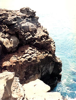
Laupāhoehoe is a census-designated place (CDP) in Hawaiʻi County, Hawaii, United States, in the District of North Hilo. The population was 581 at the 2010 census, up from 473 at the 2000 census. The community's name means "lava tip" and refers to the angular lava tip or cape formed by ancient pāhoehoe flows which created the cape on which the community was built.
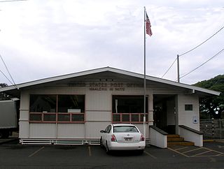
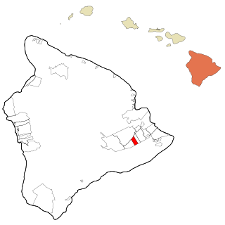
Nāʻālehu is a community in Hawaiʻi County, Hawaii, United States. Nāʻālehu is Hawaiian for "the volcanic ashes". It is one of the southernmost communities with a post office in the 50 states of the United States. For statistical purposes, the United States Census Bureau has defined Naalehu as a census-designated place (CDP). The census definition of the area may not precisely correspond to local understanding of the area with the same name. The population was 866 at the 2010 census, down from 919 at the 2000 census.

Pa'auilo is a census-designated place (CDP) in Hawaiʻi County, Hawaii, United States. The population was 618 at the 2020 census.

The Wailuku River is a 28.0-mile-long (45.1 km) water course on the Island of Hawaiʻi in the Hawaiian Islands. It is the longest river in Hawai'i and the largest in the state by mean discharge. Its course lies mostly along the divide between the lava flows of Mauna Kea and those of Mauna Loa to the south. It arises at about the 10,800 feet (3,300 m) elevation along the eastern slope of Mauna Kea. It flows generally eastward, descending steeply from the mountain and entering the Pacific Ocean at Hilo.
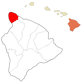
Kohala is the name of the northwest peninsula of the island of Hawaiʻi in the Hawaiian Archipelago. In ancient Hawaii it was often ruled by an independent High Chief called the Aliʻi Nui. In modern times it is divided into two districts of Hawaii County: North Kohala and South Kohala. Locals commonly use the name Kohala to refer to the census-designated places of Halaʻula, Hāwī, and Kapaʻau collectively. The dry western shore is commonly known as the Kohala Coast, which has golf courses and seaside resorts.

Route 200, known locally as Saddle Road, traverses the width of the Island of Hawaiʻi, from downtown Hilo to its junction with Hawaii Route 190 near Waimea. The road was once considered one of the most dangerous paved roads in the state, with many one-lane bridges and areas of marginally maintained pavement. Most of the road has now been repaved, and major parts have new re-alignments to modern standards. The highway is mostly one-lane in each direction, but there are two lanes on the uphill portions. The highway reaches a maximum elevation of 6,632 feet (2,021 m) and is subject to fog and low visibility. Many rental car companies used to prohibit use of their cars on Saddle Road, but now allow use of the road. The highway experiences heavy use as it provides the shortest driving route from Hilo to Kailua-Kona and access to the slopes of Mauna Loa and the Mauna Kea Observatories.
Ka Lae, also known as South Point, is the southernmost point of the Big Island of Hawaii and of the 50 United States. The Ka Lae area is registered as a National Historic Landmark District under the name South Point Complex. The area is also known for its strong ocean currents and winds and is the home of a wind farm.
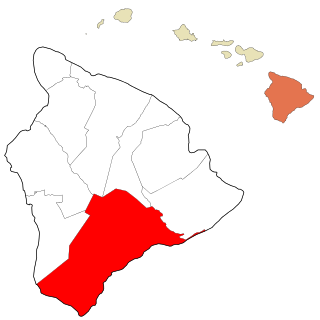
Kaʻū is the southernmost and largest district of Hawaii County, Hawaii, located on the island of Hawaiʻi.

Kēōkea is an unincorporated populated place in Hawaiʻi County, Hawaii, United States. It is located at 19°25′10″N155°52′58″W, near the junction of Māmalahoa Highway and Keala o Keawe Road, elevation 960 feet (290 m). Satellite imagery shows evidence of a humid climate with agriculture dominant around the settlement. Just to the north is the area of Hōnaunau. It was the name for the land division (ahupuaʻa) of ancient Hawaiʻi that stretched from the shoreline to Mauna Loa owned by Mataio Kekūanaōʻa.

Liliʻuokalani Park and Gardens is a 24.14-acre (97,700 m2) park with Japanese gardens, located on Banyan Drive in Hilo on the island of Hawaiʻi.

Kohala Mountain Road, designated Route 250, travels upon the Kohala mountain on the island of Hawaiʻi in Hawaii County, Hawaii, United States.
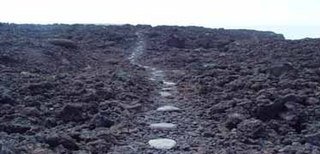
Ala Kahakai National Historic Trail is a 175-mile (282 km) long trail located on the island of Hawaii. It is not yet a single continuous trail, but can be accessed at several broken segments along the coastline of the Big Island. The trail was established to access the traditional Ancient Hawaiian culture along with the natural geology of the island. The trail was established 14 November 2000 as a National Historic Trail which is managed under the National Park Service. The trail has received funds from the Land and Water Conservation Fund.
Nīnole is the name of two unincorporated communities on the island of Hawaiʻi in Hawaiʻi County, Hawaii, United States. In the Hawaiian language Nīnole means "bending". Nīnole also has the highest percentage of people of Italian descent in Hawaii.

Laupāhoehoe High and Elementary School was a public, co-educational high school, middle school and elementary school of the Hawaii State Department of Education. It serves grades kindergarten through twelve and was established in 1904. It was converted to a public charter school in 2012.

