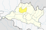
Dhading District, a part of Bagmati Province, is one of the seventy-seven districts of Nepal. The district, with Dhading Besi as its district headquarters, covers an area of 1,926 square kilometres (744 sq mi), had a population of 338,658 in 2001 and 336,067 in 2011.
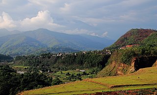
Nuwakot District (Nepali: नुवाकोट जिल्ला, a part of Bagmati Province, is one of the seventy-seven districts of Nepal. The district, with Bidur as its district headquarters, covers an area of 1,121 km2 and had a population of 288,478 in 2001 and 277,471 in 2011. It is a historically important district in Nepal. Prithvi Narayan Shah died in Devighat of Nuwakot.

The "Nepal Scouts" is the national Scouting and Guiding organization of Nepal, founded in Nepal in 1952. It became a member of the World Organization of the Scout Movement in 1969 and later became a member of the World Association of Girl Guides and Girl Scouts in 1984.
Baluwa is a village and former Village Development Committee that is now part of Gokarneshwar Municipality in Kathmandu District in Bagmati Province of central Nepal. At the time of the 2011 Nepal census it had a population of 5,467 and had 1,204 houses in it. It is located at north-east side from the capital city of Nepal. It touch Nuwakot District to the north and Gorkna VDC to the south. In east side, there is Nayapati VDC and in west Kapan VDC.
Jhor Mahankal is a village and former village development committee which is part of the Tokha municipality in Kathmandu District, Bagmati Province of central Nepal. It had a population of 4,103 in the 2011 Nepal census, with 873 households. Jhor Mahankal is known for Baruneshwar Gufa and its waterfalls. A number of clans live there, primarily the Adhikaris, Lamichanne, Dulals, Bidari, and Tamang. Jhor Mahankal is 7 kilometres (4.3 mi) from Kathmandu, with bus service from the Jhor bus station to Simalchour Syampati and Samakhushi and Ratna Park in Kathmandu.
Gimdi is one of former Village Development Committee of Lalitpur, Nepal. The village is around 80 kilometer away from Kathmandu. It lies in Ward No. 7 of Bagmati Rural Municipality, Lalitpur Province No. 3 of central Nepal. According to National Population Census, 2299 people who lived of 461 household in Nepal in 2011. It has touched the border of Mahankal Rural Municipality of Lalitpur and Bagmati Rural Municipality of Makwanpur District.
Buipaबुइपा is a village and Village Development Committee in Khotang District in the Sagarmatha Zone of eastern Nepal. At the time of the 1991 Nepal census it had a population of 5,195 persons living in 980 individual households.
Bhalche is a village development committee in Nuwakot District in the Bagmati Zone of central Nepal. At the time of the 1991 Nepal census it had a population of 2947 living in 624 individual households.
Chaturale(Nepali:चतुराले) is a village in the Nuwakot District of Nepal. The Chaturale village lies in between two rivers, Dhade Khola and Sindure Khola. Chaturale is now located in Kakani Rural Municipality ward no 7. Chaturale is named after its founder, Chatur Bhuj Ale. The biggest occasion is mainly celebrated in Chaturale bazar.

Dui Pipal is a former Village Development Committee in Nuwakot District, Nepal. According to the new province system adopted by the government of Nepal, Dui Pipal lies in Belkotgadhi municipality. It is about 65 km from the capital city Kathmandu.
Okharpauwa is a village development committee in Nuwakot District in the Bagmati Zone of central Nepal. At the time of the 1991 Nepal census it had a population of 5572 people living in 1003 individual households.

Ratmate is a ward under Belkotgadhi Municipality but was village development committee in Nuwakot District in the Bagmati Province of central Nepal. At the time of the 1991 Nepal census it had a population of 2997 people living in 567 individual households. Bhubaneshwor Nepal is the president of this ward after local election held in 2079 BS where Mr. Nepal secured total of 835 votes. There are Villages like of Mahadevphant, ratmate and Chandretar. Mahadev Secondary School is the main educational hub. There are few brick company factory and there are huge sand/aggregate excavation from Trishuli river.
Bhuji/Bhujee is ward number 7 of the seven total ward numbers of Umakunda Rural Municipality/उमाकुण्ड गाउँपालिका then village development committee in Ramechhap District in the Janakpur Zone in the Bagmati Province of north-eastern Nepal. At the time of the 1991 Nepal census it had a population of 2,285 people living in 450 individual households.
Byans is a rural area of the Byans Rural Municipality in the Darchula District and Sudurpashchim Province of Nepal. At the time of the 1991 Nepal census, the population was 723; by the 2011 Nepal census, it had dropped to 556.
Bindyabasini is a rural municipality in Parsa District in Province No. 2 of Nepal. It was formed in 2016 occupying current 5 sections (wards) from previous 5 former VDCs. It occupies an area of 26.04 km2 with a total population of 24,468. It now consists of 5 wards of 14 small villages

Tarakeshwar Rural Municipality is a Gaunpalika in Nuwakot District in Bagmati Province of central Nepal that was established in 11 March 2018 by merging the former Village Development Committees Khadga Bhanjyang(Ward no. 1 and 3), Gorsyang, Taruka and Dangsing. The headquarters of Tarkeshwor Gaupalika is located in Dangsing.

Kalinchowk is a Rural municipality located within the Dolakha district of the Bagmati province of Nepal. The municipality spans 132.49 square kilometres (51.15 sq mi) of area, with a total population of 22,954 according to a 2011 Nepal census.
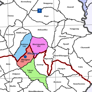
Bhojpur is a neighborhood in Bhojpur Municipality which is located in Bhojpur District in Province No. 1 of Nepal. The Bhojpur Village Panchayat was established in 1962 and was renamed as Bhojpur Village development committee in 1990.
Sisdol landfill is a location to dump solid waste from Kathmandu, Lalitpur, Bhaktapur, Kakani, and Banepa. It is the biggest dumping site of Nepal. 100 tons of solid waste is dumped at the site daily. The landfill is located at Kakani Rural Municipality of Nuwakot district.
