
The Ravi River is a transboundary river crossing northwestern India and eastern Pakistan. It is one of five rivers associated with the Punjab region.

The Mahi is a river in western India. It rises in Madhya Pradesh and, after flowing through the Vagad region of Rajasthan, enters Gujarat and flows into the Arabian Sea. It is one of the relatively few west-flowing rivers in India, alongside the endorheic Luni River, the Sabarmati River, the Tapi River and the Narmada River. Most peninsular rivers in India flow eastward into the Bay of Bengal or northward into the Ganges River.
Bayana is a historical town and the headquarters of Bayana tehsil in Bharatpur district of Rajasthan in India. Hindaun City is nearest city of Bayana - 33 km. Bayana is also known as the city of 'Vansasur'. It was the site of famous Important Battle of Bayana in 1527 between the Rajput king Rana Sanga of Mewar and Mughal emperor Babur.
The Gambhir River, which is also known as the Utangan River, is an ephemeral (seasonal) river in India which originates in Rajasthan state and confluences with Yamuna in Uttar Pradesh state. Important tributaries of the Gambhir are Banganga, Sesa, Kher, Churaho and Parbati.

Bharatpur District is a district in Rajasthan state in western India. The city of Bharatpur is the District Headquarters, Division Headquarters and Headquarters of Bharatpur Police Range of Rajasthan Police. Bharatpur District is a part of National Capital Region of India Delhi.
Karauli District is a district of the state of Rajasthan in western India. It is located in the Braj Bhoomi region. The town of Karauli serves as the administrative headquarters of the district. Karauli district also comes under the Bharatpur Divisional Commissionerate.
Dholpur District is a district of Rajasthan state in Northern India. The town of Dholpur is the district headquarters. Dholpur District is a part of Bharatpur Divisional Commissionerate. It was carved out from the erstwhile Bharatpur District on 15 April 1982.

Jawai Bandh is a dam built across the Jawai River, a tributary of Luni River, in Rajasthan.
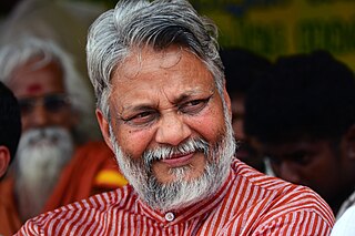
Rajendra Singh is an Indian water conservationist and environmentalist from Alwar district, Rajasthan in India. Also known as "waterman of India", he won the Magsaysay Award in 2001 and Stockholm Water Prize in 2015. He runs an NGO called 'Tarun Bharat Sangh' (TBS), which was founded in 1975. The NGO based in village hori-Bhikampura in Thanagazi tehsil, near Sariska Tiger Reserve, has been instrumental in fighting the slow bureaucracy, mining lobby and has helped villagers take charge of water management in their semi-arid area as it lies close to Thar Desert, through the use of johad, rainwater storage tanks, check dams and other time-tested as well as path-breaking techniques. Starting from a single village in 1985, over the years TBS helped build over 8,600 johads and other water conservation structures to collect rainwater for the dry seasons, has brought water back to over 1,000 villages and revived five rivers in Rajasthan, Arvari, Ruparel, Sarsa, Bhagani and Jahajwali. He is one of the members of the National Ganga River Basin Authority (NGRBA) which was set up in 2009, by the Government of India as an empowered planning, financing, monitoring and coordinating authority for the Ganges (Ganga), in exercise of the powers conferred under the Environment (Protection) Act, 1986. In the UK he is a founder member of an NGO called the Flow Partnership which aims to counter the negative effects of soil erosion and flooding.
The origin of Jawai river is in the hills of Goriya village of Bali town, located on the border of Pali and Udaipur districts.
The Kothari River rises from the Aravalli hills near Devgarh in the Rajsamand district. It flows through the tehsils (districts) of Raipur, Mandal, Bhilwara and Kotri and ultimately joins the river Banas at Nandrai in Kotri tehsil. The Meja dam on the Kothari river provides drinking water to the Bhilwara district.
Hindaun is a Block in Karauli district of the Indian state of Rajasthan in Northern India. It is a subdivisional headquarter. Its population is approximately 442,000. The block covers an area of 700 Square kilometres, which makes it the biggest block in Karauli. The subdistrict code of Hindaun Block is 00522. There are about 165 villages in Hindaun Block.
Kailadevi is a village in Karauli Tehsil, in the Karauli District of the Indian state of Rajasthan. It falls under the Bharatpur Division. It is 26 km south of the district center Karauli, and 146 km from the state capital, Jaipur.
Western Yamuna Canal is canal in river Yamuna that was dug out and renovated in 1335 CE by Firoz Shah Tughlaq. In 1750 CE, excessive silting caused it to stop flowing. The British raj undertook a three-year renovation in 1817 by Captain GR Blane of the Bengal Engineer Group. In 1832-33 Tajewala Barrage dam at Yamunanagar was also built to regulate the flow of water, and later Pathrala barrage at Dadupur,Yamuna Nagar and Somb river dam downstream of canal were constructed in 1875-76. In 1889-95 the largest branch of the canal Sirsa branch was constructed. The modern Hathni Kund Barrage was built in 1999 to handle the problem of silting to replace the older Tajewala Barrage.

Banganga River, an 240 km long tributary of Gambhir river in India, originates from the hills of Aransar and Bairath in Jaipur region of Rajasthan state and converges with Yamuna near Fatehabad in Agra district of Uttar Pradesh state. Its main tributaries are Gumti Nalla and Suri River on right bank, and Sanwan and Palasan Rivers on left bank. Banganga's tributary Sanwan after converging with Tildah river then converges with Banganga river which in turn then converges with the Gambhir river which in turn converges with the Yamuna in Mainpuri district of Uttar Pradesh. Finally, Yamuna converges with Ganges at Triveni Sangam in Prayagraj.

Meshwo or Meshwa is a river flowing in north and central parts Gujarat, state of India. Meshwo is the tributary river of the Sabarmati and subtribunary of the Vatrak River. It rises in the Panchara hills of Aravalli range, in the Dungarpur district of Rajasthan and enters in Gujarat at Shamlaji.
The Parbati River is a river in northern India, originating from the hills of the village of Chhawar in the Sapotara tehsil of the Karauli district in Rajasthan. It flows through the mountains and eventually merges with the Gambhir River in the Dholpur district.

Bandh Baretha is a freshwater man-made wetland and wildlife sanctuary covering an area of 10 square kilometers. It is located approximately 50 kilometers south of Bharatpur city, in the Bayana tehsil of Bharatpur, India. This sanctuary serves as a significant winter resort for migratory birds and plays a crucial role in storing drinking water for the region.

The Kakni river, also known as the Masurdi river or the Kakneya river, is a small seasonal river located in Jaisalmer district of Rajasthan, India. It originates approximately 27 km (17 mi) in the hills south of the village of Kotari and flows for a few kilometres before draining into the Bhuj lake. It is the smallest river among the inland rivers of Rajasthan.
Panchana Dam is a freshwater man-made wetland located in Gudla village, Krauli district, Rajasthan, approximately 100 km southeast of Bharatpur. Positioned upstream of the Gambhir River at Krauli, water from this river is crucial for reaching Keoladeo National Park by September. Failure to release water could impact migratory bird visits to the park. The dam stores water from five rivers, supplying Krauli, Sawai Madhopur, and Bharatpur.

