In the former Ottoman countries, a kaldırım (Turkish) or kalderimi (Greek: καλντερίμι or καλντιρίμι; plural kalderimia) is a cobblestone-pavedroad built for hoofed traffic. Kalderimia are sometimes described as cobbled or paved mule tracks or trails.[1][2]
Kalderimia are typically 2m wide, though there are reports of widths from 1 to 4.5m, "so that two fully laden mules could pass each other without much difficulty".[3][4][5]
In Greece, the kalderimi network formerly linked almost every village, hamlet, chapel, and even sheepfold. There were thousands of kilometers of these roads in Crete alone.[3] These roads are paved with flat stones. As they are designed for foot and hoofed traffic, they have steps where necessary, made of stones laid vertically. On flat stretches, they may be unpaved. On slopes, they have retaining walls.[3]Kalderimia use switchbacks on steep ascents, and often have parapets next to steep slopes. When they cross streams, there may be paved fords.[6]
The Skala of Vradeto (Greek: Σκάλα Βραδέτου) is a well-known kalderimi in the Epirus village of Vradeto used to enter the Vikos Gorge.[7]
After many years of neglect, overgrowth, and destruction for modern road-building, there are now some initiatives to map and restore kaldirimia for walking tourism.[3][8]
In Turkish, a kaldırım is more generically a paved street, for example the steep stepped Yüksek Kaldırım in Karaköy, Istanbul.
History
Kalderimia existed under the Ottoman Empire, and the name is Turkish, but it is not clear when they were first built. Many may follow earlier Roman and Venetian roads, with new paving.[9][10][6][11]
In many parts of rural Greece, the kalderimia were the principal means of travel until the 1960s or 1970s. Unlike modern roads, which generally connect adjacent villages at the same altitudes, the kaldemiri network mostly ran up and down the mountainsides, connecting to villagers' fields. The modern roads have now changed the relations among villages:
Previously, communications between villages were via the old kalderimia... the most direct communication between villages other than those adjacent to each other was usually over the top of the peninsula and down again. Thus, although the old communication system was organised primarily on a vertical axis, the new one had a horizontal axis. In addition, the kalderimia communication system tended to take people close to areas which belonged to them as they travelled up and down the mountain between villages. In the new system, their travel was divorced from proximity to most of their land. ... Travel between [villages on opposite sides of the peninsula] by the new vehicular road... had Loutra as its hub, ... often with a protracted stop there.... Road-construction programmes on Methana have therefore unintentionally changed Methanites' cognitive maps of the landscape.
The name kalderimi comes from Turkishkaldırım 'pavement', from kaldır- 'to raise, erect' + kaldır- + -im (deverbal noun suffix).[13][14][15] A popular etymology derives it from Greek καλός δρόμος 'good road'.[15]
Notes
↑ Loraine Wilson, The High Mountains of Crete (Cicerone Mountain Guide), ISBN1852845252, 2010, passim.
↑ Brian Anderson, Eileen Anderson, Sunflower Guide Lesvos, 2007, passim
1 2 3 4 Rolf Goetz, Crete: The finest coastal and mountain walks, Rother Walking Guide, ISBN3763348409, p. 16-17
↑ Edward W. Kase, The Great Isthmus Corridor Route: Explorations of the Phokis-Doris Expedition (Publications in Ancient Studies; No. 3), 1991, ISBN0840365381, p. 43
↑ Maria-Foteini Papakonstantinou, José Pascual, José Pascual, Topography and History of Ancient Epicnemidian Locris, 2013, ISBN900425675X, p. 283
↑ Martha W. Baldwin Bowsky, Vanna Niniou-Kindeli, "On the Road Again: A Trajanic Milestone and the Road Connections of Aptera, Crete", Hesperia: The Journal of the American School of Classical Studies at Athens75:3:405-433 (Jul. - Sep., 2006) JSTOR25067995, p. 415
↑ Yanis A. Pikoulas, "The Road-Network of Arkadia" in Thomas Heine Nielsen, James Roy, eds., Defining Ancient Arkadia, 1999, ISBN8778761603, p. 248-319
↑ Hamish Forbes, Meaning and Identity in a Greek Landscape: An Archaeological Ethnography, Cambridge University Press 2007, ISBN0521866995, p. 90ff
Crete is the largest and most populous of the Greek islands, the 88th largest island in the world and the fifth largest island in the Mediterranean Sea, after Sicily, Sardinia, Cyprus, and Corsica. Crete rests about 160 km (99 mi) south of the Greek mainland, and about 100 km (62 mi) southwest of Anatolia. Crete has an area of 8,450 km2 (3,260 sq mi) and a coastline of 1,046 km (650 mi). It bounds the southern border of the Aegean Sea, with the Sea of Crete to the north and the Libyan Sea to the south.
The Cilician Gates or Gülek Pass is a pass through the Taurus Mountains connecting the low plains of Cilicia to the Anatolian Plateau, by way of the narrow gorge of the Gökoluk River. Its highest elevation is about 1000m.
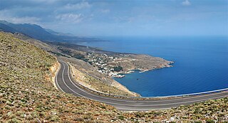
Sfakiá is a mountainous area in the southwestern part of the island of Crete, in the Chania regional unit. It is considered to be one of the few places in Greece that have never been fully occupied by foreign powers. With a 2011 census population of 1,889 inhabitants living on a land area of 467.589 km2 (180.537 sq mi), Sfakia is one of the largest and least densely populated municipalities on the island of Crete. The etymology of its name is disputed. According to the prevailing theory, it relates to its rugged terrain, deriving from the ancient Greek word σφαξ, meaning land chasm or gorge.
The Pindus is a mountain range located in Northern Greece and Southern Albania. It is roughly 160 km long, with a maximum elevation of 2,637 metres (8652'). Because it runs along the border of Thessaly and Epirus, the Pindus range is known colloquially as the spine of Greece. The mountain range stretches from near the Greek-Albanian border in southern Albania, entering the Epirus and Macedonia regions in northern Greece down to the north of the Peloponnese. Geologically it is an extension of the Dinaric Alps, which dominate the western region of the Balkan Peninsula.
The Vikos–Aoös National Park is a national park in the region of Epirus in northwestern Greece. The park, founded in 1973, is one of ten national parks in mainland Greece and is located 30 kilometres (19 mi) north of the city of Ioannina in the northern part of the Pindus mountain range. It is named after the two major gorges of the area and encompasses 12,600 hectares of mountainous terrain, with numerous rivers, lakes, caves, deep canyons, dense coniferous and deciduous forest. The park is part of the Natura 2000 ecological network and one of UNESCO Geoparks and spans an elevation range from 550 to 2,497 meters. Over 100,000 people visit the park each year and take part in activities including rafting, canoe-kayaking, hiking and mountain biking.
Zagori, is a region and a municipality in the Pindus mountains in Epirus, in northwestern Greece. The seat of the municipality is the village Asprangeloi. It has an area of some 1,000 square kilometres (390 sq mi) and contains 46 villages known as Zagori villages, and is in the shape of an upturned equilateral triangle. Ioannina, the provincial capital, is at the southern point of the triangle, while the south-western side is formed by Mount Mitsikeli (1,810m). The Aoos river running north of Mt Tymphe forms the northern boundary, while the south-eastern side runs along the Varda river to Mount Mavrovouni (2,100m) near Metsovo. The municipality has an area of 989.796 km2. The population of the area is about 3,700, which gives a population density of 4 inhabitants per square kilometer, very sparse when compared to an average of 73.8 for Greece as a whole.
Papingo is a former community (1919-2010) in the Ioannina regional unit, Epirus, Greece. Since the 2011 local government reform it has become part of the municipality of Zagori, of which it is a municipal unit. The municipal unit has an area of 34.131 km2. It is located in the Vikos–Aoös National Park.
Ioannina is one of the regional units of Greece.
Dikti or Dicte is a mountain range on the east of the island of Crete in the regional unit of Lasithi. On the west it extends to the regional unit of Heraklion. According to some versions of Greek mythology, Zeus was reared on this mountain in a cave called Dictaeon Antron. On the north of the main massif, the Lasithi Plateau is located. The topology of the mountain range is rich with plateaus, valleys and secondary peaks. Some important peaks are Spathi 2148m, Afentis Christos/Psari Madara 2141m, Lazaros 2085m, Madara 1783m, Skafidaras 1673m, Katharo Tsivi 1665m, Sarakino 1588m, Afentis 1571m, Selena 1559m, Varsami 1545m, Toumpa Moutsounas 1538m, Platia Korfi 1489m, Mahairas 1487m, Virgiomeno Oros 1414m. The main massif forms a horseshoe around the valley of Selakano. Large parts of the mountain area, including the Selakano valley, are forested with pines, Kermes oaks, cypresses, Holm Oaks and Cretan Maples. The fertile valleys and plateaus of Dikti/Dicte are of significant importance in the local economy.
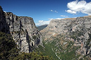
The Vikos Gorge or Vikos Canyon is a gorge in the Pindus Mountains of north-western Greece. It lies on the southern slopes of Mount Tymphe with a length of about 32 km, depth ranging from 120 to 1350 m, and a width ranging from 2500 m to only a few meters at its narrowest part.
The Monastery of Saint Paraskevi is an abandoned monastery situated on the edge of Vikos Gorge, in the region of Zagori, northwestern Greece. The monastery founded at 1413–1414, consists of a small stone-built chapel, the oldest preserved in Zagori, and offers panoramic views to the gorge.
Tymphe or Tymfi, Timfi, also Tymphi is a mountain in the northern Pindus mountain range, northwestern Greece. It is part of the regional unit of Ioannina and lies in the region of Zagori, just a few metres south of the 40° parallel. Tymphe forms a massif with its highest peak, Gamila, at 2,497 m (8,192 ft).
Makry Gialos is a former municipality in Lasithi, Crete, Greece, with a population 3,894 in 2011. It is located on the south-east coast of Crete. Since the 2011 local government reform it is part of the municipality Ierapetra, of which it is a municipal unit. The municipal unit has an area of 159.229 km2 (61.479 sq mi). The seat of the municipality was in Koutsouras, 22 kilometers east of Ierapetra. It was established in 1998 when the communities of Schinokapsala, Orino, Stavrochori, Chrisopigi, Aghios Stefanos, Pefki, Lithines and Pervolakia amalgamated into one municipality (Δήμος).
Imbros Gorge is an 11 km long canyon located near Hora Sfakion in southern Crete, the Mediterranean island. It runs parallel to Samariá Gorge, its narrowest part has 1.60 m and it ends at the village of Kommitádes. The Imbros village is located at an altitude of 780 meters and is at the South end of the fertile plain of Askyfou.
Piana is a historical village of Arcadia and one of the traditional Greek villages of Peloponnese. It is built at the Mainalo mountain, near the ruins of the ancient city Dipaia. Its population was 70 at the 2011 census.
Greece is a country of the Balkans, in Southeastern Europe, bordered to the north by Albania, North Macedonia and Bulgaria; to the east by Turkey, and is surrounded to the east by the Aegean Sea, to the south by the Cretan and the Libyan Seas, and to the west by the Ionian Sea which separates Greece from Italy.
Vradeto is a village in the Greek Zagori region. It lies at a height of 1340m on Mt Tymphe in the Pindus mountain range. It is the highest of the 44 villages of Zagori.
Vikos, also known as Vitsiko, is a village in the Central Zagori municipal unit in Ioannina regional unit, Greece. It lies at the northern end of the Vikos Gorge. A paved path leads from the village to the Voidomatis springs in the gorge.
Omalos is a small village in western Crete, in the Mousouroi unit of the Chania region. The Greek word Ομαλός means even, plain, regular, or smooth, referring to the plateau.
Ha Gorge is a narrow gorge, at the Monasteraki Dakos, on the eastern part of the island of Crete in Greece. It is located in the west slope of Thrypti mountain range, and exits east of Vasiliki village in the plain of Ierapetra. From this location scenic views overlook Pahia Amos and the bay. Being practically inaccessible to people, the gorge maintains a rich and diverse flora and fauna. Its depth is about 1,000 metres (3,300 ft) and the fissure is said to be one of the largest in the world. Late Minoan IIIC sites are in the area.
This page is based on this Wikipedia article Text is available under the CC BY-SA 4.0 license; additional terms may apply. Images, videos and audio are available under their respective licenses.