
Kochi, also known by its former name Cochin, is a major port city along the Malabar Coast of India bordering the Laccadive Sea. It is part of the district of Ernakulam in the state of Kerala. The city is also commonly referred to as Ernakulam. As of 2011, the Kochi Municipal Corporation had a population of 677,381 over an area of 94.88 km2, and the larger Kochi urban agglomeration had over 2.1 million inhabitants within an area of 440 km2, making it the largest and the most populous metropolitan area in Kerala. Kochi city is also part of the Greater Cochin development region and is classified as a Tier-II city by the Government of India. The civic body that governs the city is the Kochi Municipal Corporation, which was constituted in the year 1967, and the statutory bodies that oversee its development are the Greater Cochin Development Authority (GCDA) and the Goshree Islands Development Authority (GIDA).
Aluva is an eastern suburb of the city of Kochi in Kerala, India. It is a part of the Kochi metropolitan area and is situated around 15 km (9.3 mi) from the city centre on the banks of Periyar River. A major transportation hub, with easy access to all major forms of transportation, Aluva acts as a corridor which links the highland districts to the rest of Kerala. Cochin International Airport at Nedumbassery is 11.7 km from Aluva. Aluva is accessible through rail, air, metro along with major highways and roadlines. Aluva KSRTC bus station is an important transport hub in Kerala and one of the busiest stations in central part of the state.

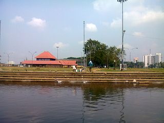
The Jawaharlal Nehru International Stadium, also known as Kaloor Stadium, is a multi-purpose stadium in Ernakulam, Kerala, India. Since the 2017 renovation, the stadium has a seating capacity of 40,000. Previously, it was able to host 80,000 spectators, which was reduced to 41,000 for Indian Super League (ISL) matches due to security reasons. It is the home ground of the ISL club Kerala Blasters FC. The stadium is touted to have hosted one of the loudest audiences for association football matches in the world.

Greater Cochin Development Authority (GCDA) is the statutory body overseeing the development of the city of Kochi in the state of Kerala, India. Headquartered at Kadavanthra, GCDA oversees the development of the major part of Greater Cochin area which consists of the Kochi Municipal Corporation, surrounding municipalities and 21 intervening panchayats covering an area of 632 km2.

Ernakulam Town (station code: ERN) is an NSG–3 category Indian railway station in Thiruvananthapuram railway division of Southern Railway zone. It is a railway station in the city of Kochi, Kerala. It is the second major railway station in Kochi after Ernakulam Junction. It is located in the northern part of the city and handles around 90 trains daily. With an annual passenger footfall of 1.02 crore, Ernakulam Town railway station serves as a main stop in Ernakulam for the trains that travels through the Kottayam line.
Kochi is a major port city in the Indian state of Kerala. The city is widely known as the commercial or economic capital of the state of Kerala.

Kadavanthra is a ward in downtown Kochi, Kerala. It is bounded by the S.A Road to the east and the Giri Nagar canal in the west. Kadavanthra is a major commercial centre of Kochi, and a prime residential area. In recent years, the ward has undergone rapid development to become one of Kochi's highest-valued regions.

Pachalam is a region in the city of Kochi in Kerala, India. Goshree bridge road at Marine Drive side ends at Pachalam. Pachalam can also be reached by Chittoor Road. Mulavukad island is on its west, Vaduthala and Chittoor island is on its north, Elamakkara at north east, Mamagalam and Palarivattom is on its east, Kaloor on southeast. It is also located between Marine Drive, Kaloor and Edapally acting as a connecting link between the most important places in Kochi. One of the main attractions near Pachalam is the famous Queen's Walkway, that connects Pachalam to the Gosree bridge Road and to Marine Drive. Although the roads are very narrow, the traffic has increased, as roads inside Pachalam give a much needed respite to motorists who were looking an alternative to escape from the hardships of motoring through Banerjee Road especially during this phase of Kochi Metro construction.
Vazhakala is a neighbourhood region in the city of Kochi in Kerala, India. It is situated around 5 km (3 mi) from the city center and is part of Thrikkakkara Municipality. It can be classified as a typical residential area adjacent to schools, colleges and professional institutions.it has a history about 150 years mainly associated with age old churches and temples.

The Kochi Metro is a rapid transit system serving the city of Kochi and the wider Kochi Metropolitan Region in Kerala, India. It was opened to the public within four years of starting construction, making it one of the fastest completed metro projects in India. The Kochi metro project is the first metro system in the country which connects rail, road and water transport facilities. It is also the first metro rail system in India to be operated using the Communication-Based Train Control (CBTC) signalling system, which requires minimum human intervention. The Kochi Water Metro is integrated with the Kochi Metro, which also serves as a feeder service to the suburbs along the rivers where transport accessibility is limited.

Elamkulam is a ward of Kochi, Kerala. Elamkulam is a part of the Kadavanthra pincode and Kadavanthra Janamythri Police station. Elamkulam is well facilitated with Metro railway station which works as an extension counter to Kadavanthra metro station to cater to passengers who want to shop at branded outlets like MAX,Trends etc. Elamkulam metro station also privileges direct entry to Radisson Blu Kochi.

Kaloor is a downtown region in the city of Kochi, in the state of Kerala, India. It is two kilometres (1.2 mi) from the Ernakulam North Railway Station. Kaloor Junction is also the name of a major intersection in this part of the city, intersecting the two major arteries of downtown Kochi, namely Banerji Road and the Kaloor-Kadavanthra Road. The nearest major intersections are Palarivattom to the east and Lissie Junction to the west.
Sahodaran Ayyappan Road, popularly known as S.A Road is one of the most important and the second main arterial road of CBD Kochi city ; it is supposed to be the busiest and most congested road in the city of Kochi, which run in east-west direction and the shortest road connecting the two main iconic junctions in the city. The road connects the MG Road in west with Vyttila Junction & Hub in east and continues further as Tripunithura Road that connects to Tripunithura, hence termed as the back bone road of Kochi.
This is a list of major areas and neighbourhoods in the city of Kochi by region. The eastern part of Kochi is mainly known as Ernakulam, while the western part of the city after the Venduruthy Bridge is called as Western Kochi.
Kaloor-Kadavanthra Road is an arterial road of Kochi City. Also known as KK Road, it is one of the three north-south arteries in the city of Kochi. Kaloor-Kadavanthra Road starts at the Kadavanthra Junction and ends at Kaloor; Kadavanthra Junction and Kaloor are the two major junctions in the city of Kochi. Kaloor-Kadavanthra Road intersects the Sahodaran Ayyappan Road from Vytila (East) to Pallimukku Junction (West) at Kadavanthra Junction. The South extension of the Kaloor-Kadavanthra Road is the KP Vallon Road. Most of the long distance buses that connect the city to the regions of the south and southeast use this road to reach their main terminal at Kaloor. This 3.2 km long, 22 m wide, 4-lane city highway was planned to ease the load on the busy MG Road. The city is divided into two parts by the railway line running in a north-south direction. This road fills the need for an artery on the eastern sector, avoiding the choke points of the two railway overpasses. The road also has multiple banks along its route, such as the State Bank of India at Grand Bay, ICICI, Bank of India, HDFC, Central Bank of India -Kallelil Building, Kadavanthra Jn, etc. The condition of the Kaloor-Kadavanthra Road has increased over time.
Kathrikadavu is a region in the city of Kochi, in the state of Kerala, India. It lies almost midway between the two major intersections (junctions) in Kochi, namely Kaloor and Kadavanthra. Kathrikadavu is mainly a residential area, though of late more and more commercial establishments are being set up here.

Palarivattom is a station of Kochi Metro. The station served as the south terminus of the line until the extension to Maharaja's College was opened on 3 October 2017. The station is now located between Changampuzha Park and J. L. N. Stadium. The name of the station originates from Palarivattom, the area it is located.
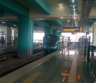
J. L. N. Stadium is a station of Kochi Metro. It was opened on 3 October 2017 as a part of the extension of the metro system from Palarivattom to Maharaja's College. The station is located between Palarivattom and Kaloor. The name of the station is given because of the Jawaharlal Nehru Stadium. The 11.2 km extension to Infopark via Kakkanad as a part of Kochi Metro project phase two begins from J. L. N. Stadium station. The corporate office of Kochi Metro Rail Limited is also located at this station.
Town Hall Metro Station is a station of Kochi Metro, formerly known as Lissie Metro Station. It was opened on 3 October 2017 as a part of the extension of the metro system from Palarivattom to Maharaja's College. The station is located between Kaloor and M. G. Road. The former name of the station refers to the name of the nearby Lissie Hospital, which, in turns, is derived from Thérèse of Lisieux. The station was renamed on 1 February 2020. The lissie railway station is located near to this metro station.

