Karimnagar is a city and District Headquarters in the Indian state of Telangana. Karimnagar is a major urban agglomeration and the third largest city in the state. It is governed by the Municipal Corporation and is the headquarters of the Karimnagar district. It is situated on the banks of Manair River, which is a tributary of the Godavari River. It is the third largest and fastest growing urban settlement in the state, according to the 2011 census. It has registered a population growth rate of 45.46% and 38.87% respectively over the past two decades between 1991 and 2011, which is the highest growth rate among major cities of Telangana. It serves as a major educational and health hub for the northern districts of Telangana. It is a major business center and widely known for its agricultural and granite industries, earning the nickname "City of Granites."
Naspur is a municipality and a suburb and mandal in Mancherial district of the Indian state of Telangana. Located the north bank of Godavari River.
Srirampur is a census town in Purbasthali I CD Block in Kalna subdivision of Purba Bardhaman in the Indian state of West Bengal.
Nuzvid mandal is one of the 28 mandals in Eluru district of the Indian state of Andhra Pradesh. It is under the administration of Nuzvid revenue division, with headquarters at Nuzvid. The mandal is bounded by Reddigudem, Vissannapeta, Chatrai, Mylavaram Agiripalli, Bapulapadu and Musunuru mandals.
Tirupati Rural mandal is one of the 34 mandals in Tirupati district of Andhra Pradesh in India. It is under the administration of Tirupati revenue division and the headquarters are located at Tirupati.
Kamanpur is a Mandal in Peddapalli district of the Indian state of Telangana. It is located in Kamanpur mandal of Peddapalli revenue division.
Saidapur is a village in Saidapur mandal of Karimnagar district in the state of Telangana in India, near Huzurabad.
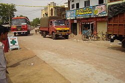
Ushannapalli is a village in Kalva Srirampur mandal, Karimnagar district of the state of Telangana, India.

Purbasthali I is a community development block that forms an administrative division in Kalna subdivision of Purba Bardhaman district in the Indian state of West Bengal.
Srirampura is a town and residential suburb of Mysore city in India. It is located in the Southern part of the city. It has a population of approximately 11,000 according to the 2011 census. The main landmarks of this area are Brahmarahbha Choultrey, SBM park, Madhuvana Park. There are several schools in and around this area. North of Srirampura is Vivekananda Nagar and Kuvempunagar. West of Srirampura is Ramakrishnanagar, East of Srirampura is Asokapuram. South of Srirampura is the Mananthavady-Mysore Highway. In November 2020, a gazetted notification was passed upgrading the census town to a town panchayat. The notification combines towns and villages of Srirampura, Lingambudhipalya, Gurur, Koppalur and Kalalavadi villages coming under Srirampura GP, covering a total area of 17.99 km2. According to 2011 census, the town has a combined population of 18,511.
Repalle mandal is one of the 25 mandals in Bapatla district of the state of Andhra Pradesh, India. It is under the administration of Bapatla revenue division and the mandal headquarters are located at Repalle. The mandal is situated on the banks of Krishna River of Velanadu region and is bounded by Bhattiprolu, Nagaram and Nizampatnam mandals.

Duggirala mandal is one of the 18 mandals in Guntur district of the Indian state of Andhra Pradesh. It is under the administration of Tenali revenue division and the headquarters are located at Duggirala. The mandal is bounded by Mangalagiri, Pedakakani, Tenali and Kollipara mandals. Krishna River lies to the northeast of the Duggirala mandal.

Gannavaram mandal is one of the 25 mandals in Krishna district of the Indian state of Andhra Pradesh. It is under the administration of Gudivada revenue division and the mandal headquarters are located at Gannavaram. The mandal is bounded by Agiripalle, Bapulapadu, Unguturu, Vijayawada (rural) and Kankipadu mandals. The mandal is also a part of the Andhra Pradesh Capital Region under the jurisdiction of APCRDA.
Kollipara mandal is one of the 18 mandals in Guntur district of the state of Andhra Pradesh, India. It is under the administration of Tenali revenue division and the headquarters are located at Kollipara. The mandal is situated on the banks of the Krishna River, bordered by Duggirala, Tenali, Vemuru and Kollur mandal.
Narasaraopet mandal is one of the 28 mandals in Guntur district of the India state of Andhra Pradesh. It is under the administration of Narasaraopet revenue division and the headquarters are located at Narasaraopet city. The mandal is bounded by Rompicherla, Nekarikallu, Muppalla, Phirangipuram, Nadendla and Chilakaluripeta. It also borders Prakasam district.
Renigunta mandal is one of the 34 mandals in Tirupati district of the Indian state of Andhra Pradesh. Its headquarters are located at Renigunta, suburb of Tirupati.. The mandal is bounded by Tirupati (urban), Tirupati (rural), Vadamalapeta, Yerpedu.This mandal is located at Srikalahasti revenue division.
Vemuru mandal is one of the 25 mandals in Bapatla district of the state of Andhra Pradesh in India. It is under the administration of Tenali Revenue Division and the headquarters are located at Vemuru. The mandal is bounded by Tenali, Kollipara and Kollur, Amruthalur, Cherukupalle and Bhattiprolu mandals. The mandal is also a part of the Andhra Pradesh Capital Region under the jurisdiction of APCRDA.

Ponnur mandal is one of the 18 mandals in Guntur district of the Indian state of Andhra Pradesh.Dhulipalla Narendra Kumar – Telugu Desam Party is the present MLA of the constituency, having won the 2024 assembly elections. It is under the administration of Tenali revenue division and the headquarters are located at Ponnur town. The mandal is bounded by Vatticherukuru, Chebrole, Tsundur, Kakumanu, Amruthalur, Pittalavanipalem, Karlapalem and Bapatla mandals.
Pedapalli district is a district located in the northern region of the Indian state of Telangana. Its administrative headquarters is at Peddapalli and Commissionerate is at Ramagundam. The district shares boundaries with Mancherial, Karimnagar, Jagtial and Jayashankar Bhupalpally districts. This district covers Ramagundam city which is situated in the Godavari valley coalfields and has one of the India's largest thermal power stations in south region under NTPC. Mostly industries are connected with Godavarikhani - NTPC - Ramagundam.
Mirzampet is a village in Kalva Srirampur mandal of Peddapalli district in the state of Telangana in India. Mirzampet has a population of 1,972 within its village limits, according to 2011 census. It has an average elevation of 155 meters