
Pineia is a former municipality in Elis, West Greece, Greece. Since the 2011 local government reform it is part of the municipality Ilida, of which it is a municipal unit. The municipal unit has an area of 148.572 km2. Its seat of administration was in the village Simopoulo. Pineia is named after the river Pineios, which forms its northern border. The area is hilly and sparsely populated. It is about 20 km east of Amaliada, 25 km northeast of Pyrgos and 45 km southwest of Patras.

Foloi is a village and a former municipality in Elis, West Greece, Greece. Since the 2011 local government reform it is part of the municipality Archaia Olympia, of which it is a municipal unit. The municipal unit has an area of 174.202 km2. The seat of the municipality was in the village Lalas, in the southern part of the municipal unit. The village Foloi is situated in the northwestern part. Foloi is situated in a mountainous, sparsely populated area. The Foloi oak forest is located in the municipal unit. Foloi is located about 15 km northeast of Olympia, 30 km east of Pyrgos and 55 km south of Patras. It borders on Arcadia to the east, across the river Erymanthus.

Karditsa is a city in western Thessaly in mainland Greece. The city of Karditsa is the capital of Karditsa regional unit of region of Thessaly.

Palamas is a town and a municipality in the Karditsa regional unit, Greece. Palamas is located south-southwest of Larissa, the capital of Thessaly, northwest of Lamia, north of Sofades, east-northeast of Karditsa and east-southeast of Trikala. Palamas is linked with the road linking Karditsa and Larissa. It also serves roads with the GR-6 and Sofades. The Pineios River is to the north as well as the Trikala regional unit.
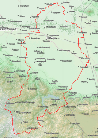
Sofades is a town and municipality in Thessaly, central Greece belonging to the regional unit of Karditsa. Its 2011 census population was 6,056 people and 18,864 for the municipality, including a large Romani community. Its elevation is around 120 m above sea level, and the economy is mainly agricultural. Sofades is located south of Palamas, southwest of Larissa, the capital of Thessaly, northwest of Lamia and southeast of Karditsa and Trikala. The native Greek inhabitants of the region are commonly known as Karagounides (Καραγκούνηδες).

Pyllini is a former municipality in Aetolia-Acarnania, West Greece, Greece. Since the 2011 local government reform it is part of the municipality Nafpaktia, of which it is a municipal unit. The municipal unit has an area of 123.966 km2. Population 676 (2021). The seat of the municipality was in Simos.

Irakleides is a former municipality on the island of Kos, in the Dodecanese, Greece. Since the 2011 local government reform, it is part of the municipality Kos, of which it is a municipal unit. Population 7,467 (2021). It is the largest in area of the three municipal units on the island, at 160.538 km², and comprises 55.3% of the island's territory. The seat of the municipality was in Antimacheia. The largest village is Kefalos. Kardamaina, Mastichari, Kampos, Onia, and Kamarion are the other villages in the municipal unit. It shares the island of Kos with the municipal units of Kos and Dikaios.

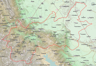
Aspropotamos is a former municipality in the northwestern part of Evrytania, Greece. Since the 2011 local government reform it is part of the municipality Agrafa, of which it is a municipal unit. The municipal unit has an area of 125.954 km2. Population 1,386 (2021). The seat of the municipality was in Raptopoulo. Aetolia-Acarnania is to the west and the Karditsa regional unit to the north. Aspropotamos is located west-southwest of Karditsa, northwest of Karpenisi and north-northeast of Agrinio. The municipality was named after the Aspropòtamos river.

Acheloos is a former municipality in the Karditsa regional unit, Thessaly, Greece. Since the 2011 local government reform it is part of the municipality Argithea, of which it is a municipal unit. The municipal unit has an area of 87.430 km2. It is named after the Acheloos River. Population 913 (2021). The seat of the municipality was in Vragkiana.

Ithomi is a former municipality in the Karditsa regional unit, Thessaly, Greece. Since the 2011 local government reform it is part of the municipality Mouzaki, of which it is a municipal unit. The municipal unit has an area of 80.491 km2. Population 1,591 (2011). The seat of the municipality was in Fanari. The name reflects the ancient town of Ithome, which, although its location is uncertain, is thought to be located nearby. The municipal unit Ithomi consists of the following communities:

Itamos is a former municipality in the Karditsa regional unit, Thessaly, Greece, named after the ancient city of "Itamos". Since the 2011 local government reform it is part of the municipality Karditsa, of which it is a municipal unit. The municipal unit has an area of 234.384 km2. Population 2,781 (2021). The seat of the municipality was in Kallithiro.

Kallifoni is a village and a former municipality in the Karditsa regional unit, Thessaly, Greece. Since the 2011 local government reform it is part of the municipality Karditsa, of which it is a municipal unit. The municipal unit has an area of 154.623 km2. Population 1,991 (2021).

Mitropoli is a village and a former municipality in the Karditsa regional unit, Thessaly, Greece. Since the 2011 local government reform it is part of the municipality Karditsa, of which it is a municipal unit. The municipal unit has an area of 57.894 km2. Population 2,892 (2021). The village, the site of the ancient city of Metropolis, was renamed in 1915 to reflect the association.
Mouzaki is a town and a municipality in the northwestern part of the Karditsa regional unit, Greece. Mouzaki is located on the southwestern edge of the Thessalian plain, where the river Pamisos descends from the Agrafa mountains. It is 17 km southwest of Trikala and 24 km northwest of Karditsa. The Greek National Road 30 passes north of the town. In 2020, Mouzaki was heavily affected by the medicane known as Cyclone Ianos. The town was flooded for several days.

Nevropoli Agrafon is a former municipality in the Karditsa regional unit, Thessaly, Greece. Since the 2011 local government reform it is part of the municipality Lake Plastiras, of which it is a municipal unit. The municipal unit has an area of 105.184 km2. Population 2,362 (2021). The seat of the municipality was in Pezoula. The municipality's name derives from the ancient city of "Nevròpolis" of the Agrafa Mountains.

Pamisos is a former municipality in the Karditsa regional unit, Thessaly, Greece, named after Pamisos river. Since the 2011 local government reform it is part of the municipality Mouzaki, of which it is a municipal unit. The municipal unit has an area of 53.854 km2. Population 3,176 (2021). The seat of the municipality was in Agnantero. The municipal unit Pamisos consists of the following communities:

Sellana is a former municipality in the Karditsa regional unit, Thessaly, Greece, named after the ancient city of "Sellana" or "Silàna". Since the 2011 local government reform it is part of the municipality Palamas, of which it is a municipal unit. The municipal unit has an area of 89.490 km2. The seat of the municipality was in Proastio, which has 1,434 inhabitants (2021). Other communities in the municipal unit are those of Marathea, Agia Triada (548), Pedino (505) and Kalogriana (475).
Krannonas is a village and a former municipality in the Larissa regional unit, Thessaly, Greece. Since the 2011 local government reform it is part of the municipality Kileler, of which it is a municipal unit. It is located southwest of the regional capital Larissa. In 2021 its population was 127 for the community and 2,007 for the municipal unit. The municipal unit has an area of 205.242 km2. The seat of the municipality was Agioi Anargyroi. It is located north of Farsala and NNE of Palamas and Karditsa.

Kampochora or Kampos, literally plain, is a former municipality on the island of Chios, North Aegean, Greece. Since the 2011 local government reform it is part of the municipality Chios, of which it is a municipal unit. It is located in the south-central part of the island. It has a land area of 50.571 km². Its population was 3,014 at the 2021 census. The seat of the municipality was in Chalkeio. Other large towns include Ágios Geórgios Sykoúsis, Dafnonas, and Vasileónoikon.

Lake Plastiras is a municipality in the Karditsa regional unit, Thessaly, Greece. The seat of the municipality is the town Morfovouni. The municipal unit has an area of 198.350 km2. The municipality was named after the artificial Lake Plastiras, that was named in turn after the Greek general and three-time prime minister Nikolaos Plastiras.

