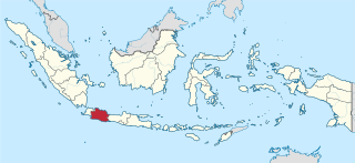
West Java is a province of Indonesia on the western part of the island of Java, with its provincial capital in Bandung. West Java is bordered by the province of Banten and the country's capital region of Jakarta to the west, the Java Sea to the north, the province of Central Java to the east and the Indian Ocean to the south. With Banten, this province is the native homeland of the Sundanese people, the second-largest ethnic group in Indonesia.

Central Java is a province of Indonesia, located in the middle of the island of Java. Its administrative capital is Semarang. It is bordered by West Java in the west, the Indian Ocean and the Special Region of Yogyakarta in the south, East Java in the east, and the Java Sea in the north. It has a total area of 34,337.48 km2, with a population of 36,516,035 at the 2020 Census making it the third-most populous province in both Java and Indonesia after West Java and East Java. The official population estimate in mid-2022 was 37,032,410. The province also includes a number of offshore islands, including the island of Nusakambangan in the south, and the Karimun Jawa Islands in the Java Sea.

The angklung is a musical instrument from the Sundanese people in Indonesia made of a varying number of bamboo tubes attached to a bamboo frame. The tubes are carved to have a resonant pitch when struck and are tuned to octaves, similar to Western handbells. The base of the frame is held in one hand, while the other hand shakes the instrument, causing a repeating note to sound. Each performer in an angklung ensemble is typically responsible for just one pitch, sounding their individual angklung at the appropriate times to produce complete melodies.

Cirebon is a port city on the northern coast of the Indonesian island of Java. It is the only coastal city of West Java, located about 40 km west of the provincial border with Central Java, approximately 297 km (185 mi) east of Jakarta, at 6°43′S108°34′E. It had a population of 296,389 at the 2010 census and 333,303 at the 2020 census; the official estimate as at mid 2022 was 341,235.

The Sunda or Sundanese are an indigenous ethnic group native to the western region of Java island in Indonesia, primarily West Java. They number approximately 42 million and form Indonesia's second most populous ethnic group. They speak the Sundanese language, which is part of the Austronesian languages.

Garut Regency is a Regency in the West Java province of Indonesia. It covers an area of 3,065.19 km2 (1,186.91 mi2). Geographically, it lies between 6°57′34″ – 7°44′57″ South latitude and 107°24′34″ – 108°7′34″ East longitude. The population at the 2010 census was 2,404,121, and at the 2020 census was 2,585,607; the official estimate as at mid 2022 was 2,627,220. South Tarogong is the regency seat.
In Indonesia, village or subdistrict is the fourth-level subdivision and the smallest administrative division of Indonesia below a district, regency/city, and province. Similar administrative divisions outside of Indonesia include barangays in the Philippines, Muban in Thailand, civil townships and incorporated municipalities in the United States and Canada, communes in France and Vietnam, dehestan in Iran, hromada in Ukraine, Gemeinden in Germany, comuni in Italy, or municipios in Spain. The UK equivalent are civil parishes in England and communities in Wales. There are a number of names and types for villages in Indonesia, with desa being the most frequently used for regencies, and kelurahan for cities or for those communities within regencies which have town characteristics. According to the 2019 report by the Ministry of Home Affairs, there are 8,488 urban villages and 74,953 rural villages in Indonesia. North Aceh Regency contained the highest number of rural villages (852) amongst all of the regencies of Indonesia, followed by Pidie Regency with 730 rural villages and Bireuen Regency with 609 rural villages. Prabumulih, with only 12 rural villages, contained the fewest. Counted together, the sixteen regencies of Indonesia containing the most rural villages—namely, North Aceh (852), Pidie (730), Bireuen (609), Aceh Besar (604), Tolikara (541), East Aceh (513), Yahukimo (510), Purworejo (469), Lamongan (462), South Nias (459), Kebumen (449), Garut (421), Bojonegoro (419), Bogor (416), Cirebon (412), and Pati (401)—contain one-third of all the rural villages in Indonesia. Five of these are located in Aceh, two in Highland Papua, three in Central Java, two in East Java, three in West Java, and one in North Sumatra. An average number of rural villages in the regencies and 15 cities of Indonesia is 172 villages. A village is the lowest administrative division in Indonesia, and it is the lowest of the four levels. A village is usually divided into a number of hamlets, and there are 252,315 hamlets in Indonesia.

Garut is a district and town in West Java of Indonesia, and the former capital of Garut Regency. It is located about 75 km to the southeast of the major city of Bandung.
Tasikmalaya Regency is a regency in the province of West Java, Indonesia. With an area of 2,708.82 km2 (1,046 sq mi), it is the biggest and most important in the southeast region of East Preanger. Tasikmalaya Regency had a population of 1,687,776 at the 2010 census and 1,865,203 at the 2020 census; the mid-2022 official estimate was 1,906,288.

Cirebon Regency is a regency (kabupaten) of West Java, Indonesia. Sumber is its capital. It covers 1,076.76 km2 and had a population of 2,068,116 at the 2010 census and 2,270,621 at the 2020 census; the official estimate as at mid 2022 was 2,315,417. These area and population figures exclude those of Cirebon City, which is an independent administration, although totally surrounded by the regency on its landward side.

The Galuh Kingdom was an ancient Sundanese kingdom located in the eastern part of Tatar Pasundan, present-day Indonesia. It was established following the end of the Tarumanagara kingdom around the 7th century. Traditionally the kingdom was associated with Eastern Priangan cultural region, around the Citanduy and Cimanuk rivers, with territory spanned from Citarum river on the west, Pamali and Serayu river on the east. Its capital was first located in Karangkamulyan, Ciamis Regency, then Saunggalah, Kuningan, and Kawali, near today Ciamis City. The etymology of "galuh" is Old Sundanese and Kawi word for "gemstone".

Parahyangan or Priangan is a cultural and mountainous region in West Java province on the Indonesian island of Java. Covering a little less than one sixth of Java, it is the heartland of Sundanese people and their culture. It is bordered to the West by Banten province, to the North by the northern coast region of Subang, Cirebon and Indramayu, to the east by Central Java province, and to the south by the Indian Ocean.

Sunda Wiwitan is a folk religion and ancient beliefs adhered to by the Sundanese in Indonesia.

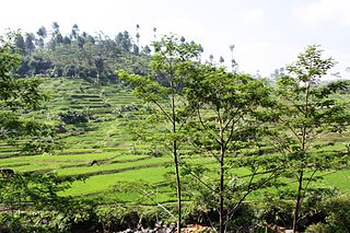
Seren Taun is an annual traditional Sundanese rice harvest festival and ceremony. The festival was originally held to mark the new agriculture year in the Sundanese ancient calendar as well as thanks giving for the blessings of the abundance rice harvest, and also to pray for the next successful harvest. Seren Taun demonstrates the Sundanese agricultural way of life, and is held in high regard in Sundanese traditional villages, as the festival draw thousands Sundanese villagers to participate as well as Indonesian or foreign visitors.

Cangkuang temple is a small 8th-century Shivaist candi located in Kampung Pulo village, Cangkuang, Kecamatan Leles, Garut Regency, West Java, Indonesia. The temple is one of very few Hindu-Buddhist temples discovered in West Java, other temples include Batujaya and Bojongmenje temple.
Ci Kaengan is a river in the island of Java, Indonesia, that flows mainly in the Garut Regency of West Java province, about 210 km to the southeast of the capital Jakarta.
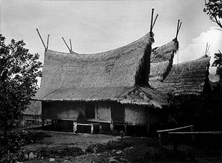
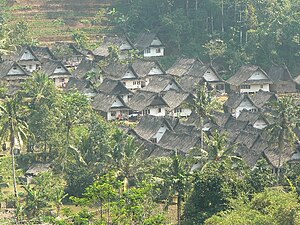
Sundanese traditional house refers to the traditional vernacular houses of the Sundanese people, who predominantly inhabited the western parts of Java island, Indonesia. The architecture of a Sundanese house is characterized by its functionality, simplicity, modesty, uniformity with a little detail, its use of natural thatched materials, and the quite faithful adherence to harmony with nature and the environment.
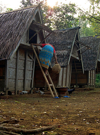
Leuit is a type of vernacular rice barn found in the Sundanese architecture of Western Java, Indonesia. It used to store rice after harvest for future and daily use. A leuit is an essential part of Sundanese agricultural tradition, especially during annual Seren Taun harvest ceremony. In Sundanese tradition, leuit symbolizes sustenance and livelihood.

The West Java Regional House of Representatives is the unicameral legislature of the Indonesian province of West Java.

Ciptagelar is a traditional Sundanese hamlet in Sukabumi Regency, West Java. Founded in 1368, the hamlet is the largest village of the Kasepuhan community which retains traditional Sundanese social structure and strictly adheres to adat to this day. The village is also known for its Sundanese style houses which value simplicity and harmony with nature.