Kan Ek'

Last updated

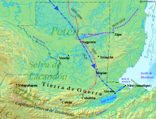
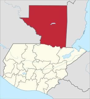
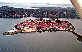
Kan Ek' (sometimes spelt Canek) was the name or title used by the Itza Maya kings at their island capital Nojpetén upon Lake Petén Itzá in the Petén Department of Guatemala. The full title was Aj Kan Ek' or Ajaw Kan Ek' , and in some studies Kan Ek' is used as the name of the Late Postclassic (c. 1200 to 1697) Petén Itza polity. [1]

Maya civilization Mesoamerican civilization

The Maya civilization was a Mesoamerican civilization developed by the Maya peoples, and noted for its logosyllabic script—the most sophisticated and highly developed writing system in pre-Columbian Americas—as well as for its art, architecture, mathematics, calendar, and astronomical system. The Maya civilization developed in an area that encompasses southeastern Mexico, all of Guatemala and Belize, and the western portions of Honduras and El Salvador. This region consists of the northern lowlands encompassing the Yucatán Peninsula, and the highlands of the Sierra Madre, running from the Mexican state of Chiapas, across southern Guatemala and onwards into El Salvador, and the southern lowlands of the Pacific littoral plain.

Maya rulers

Maya kings were the centers of power for the Maya civilization. Each Maya city-state was controlled by a dynasty of kings.Also the position of king was usually inherited by the oldest son.

Contents

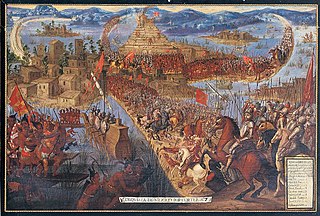
The earliest known use of the title comes from a Maya stela at the archaeological site of Yaxchilan and dates to the mid 8th century AD. The name is recorded in inscriptions at widely spaced Maya cities including Seibal, Motul de San José and Chichen Itza. When Spanish conquistador Hernán Cortés crossed Petén in the early 16th century, he met with an Itza king identified by the name Kan Ek'. The Itza were not contacted again until the early 17th century when Franciscan friars were initially welcomed by the current Aj Kan Ek' before being expelled. This was followed by several incidents in which attempts to interact with the Itza resulted in the slaughter of the Spanish and their Maya converts, resulting in a long lull before attempts were resumed with a new Kan Ek' in the closing years of the 17th century. These culminated in a bloody battle, after which the last Kan Ek' was captured; he spent the rest of his life under arrest in the colonial capital of the Captaincy General of Guatemala.

Maya stelae Intricately carved stone slabs made by the Pre-Columbian Maya

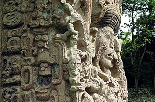
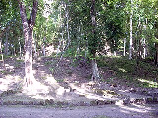
Maya stelae are monuments that were fashioned by the Maya civilization of ancient Mesoamerica. They consist of tall, sculpted stone shafts and are often associated with low circular stones referred to as altars, although their actual function is uncertain. Many stelae were sculpted in low relief, although plain monuments are found throughout the Maya region. The sculpting of these monuments spread throughout the Maya area during the Classic Period, and these pairings of sculpted stelae and circular altars are considered a hallmark of Classic Maya civilization. The earliest dated stela to have been found in situ in the Maya lowlands was recovered from the great city of Tikal in Guatemala. During the Classic Period almost every Maya kingdom in the southern lowlands raised stelae in its ceremonial centre.

Yaxchilan human settlement

Yaxchilan is an ancient Maya city located on the bank of the Usumacinta River in the state of Chiapas, Mexico. In the Late Classic Period Yaxchilan was one of the most powerful Maya states along the course of the Usumacinta River, with Piedras Negras as its major rival. Architectural styles in subordinate sites in the Usumacinta region demonstrate clear differences that mark a clear boundary between the two kingdoms.

Maya city

Maya cities were the centres of population of the pre-Columbian Maya civilization of Mesoamerica. They served the specialised roles of administration, commerce, manufacturing and religion that characterised ancient cities worldwide. Maya cities tended to be more dispersed than cities in other societies, even within Mesoamerica, as a result of adaptation to a lowland tropical environment that allowed food production amidst areas dedicated to other activities. They lacked the grid plans of the highland cities of central Mexico, such as Teotihuacán and Tenochtitlan. Maya kings ruled their kingdoms from palaces that were situated within the centre of their cities. Cities tended to be located in places that controlled trade routes or that could supply essential products. This allowed the elites that controlled trade to increase their wealth and status. Such cities were able to construct temples for public ceremonies, thus attracting further inhabitants to the city. Those cities that had favourable conditions for food production, combined with access to trade routes, were likely to develop into the capital cities of early Maya states.

Etymology

The two elements in the Kan Ek' name represent surnames taken from the mother's and father's lineage respectively. In Petén during the Postclassic period a person belonged to two lineage groups. The individual's ch'ibal group was determined by their father's lineage and their ts'akab group was determined by their mother's lineage group. Individuals simultaneously inherited their surname and property from the father's lineage group and a surname, titles and religious leanings from the lineage group of their mother. Maya rulers were members of royal lineage groups and the kan element of the king's name was inherited from the royal ts'akab while the Ek' element was derived from the royal ch'ibal '. Due to this, all the Itza kings of Petén bore the name Kan Ek'. [2] Among the Itza, kan ek' meant "serpent star"; it may also have had a secondary meaning of "sky star" (ka'an ek' ). [3]

Polity

At the time of the Spanish conquest of Petén in 1697, the Kan Ek' kingdom was one of the three dominant polities in the central Petén Basin. [4]

Spanish conquest of Petén

The Spanish conquest of Petén was the last stage of the conquest of Guatemala, a prolonged conflict during the Spanish colonisation of the Americas. A wide lowland plain covered with dense rainforest, Petén contains a central drainage basin with a series of lakes and areas of savannah. It is crossed by several ranges of low karstic hills and rises to the south as it nears the Guatemalan Highlands. The conquest of Petén, a region now incorporated into the modern republic of Guatemala, climaxed in 1697 with the capture of Nojpetén, the island capital of the Itza kingdom, by Martín de Ursúa y Arizmendi. With the defeat of the Itza, the last independent and unconquered native kingdom in the Americas fell to European colonisers.

The Petén Basin is a geographical subregion of Mesoamerica, primarily located in northern Guatemala within the Department of El Petén, and into Campeche state in southeastern Mexico.

History

The Kan Ek' name is recorded in the hieroglyphic text on Seibal Stela 11 Seibal St.11.jpg
The Kan Ek' name is recorded in the hieroglyphic text on Seibal Stela 11

The Kan Ek' name is recorded as being used by a king of Motul de San José, just north of Lake Petén Itzá, [5] as far back as the Late Classic period (c. AD 600-900) of Mesoamerican chronology. [6] Kan Ek' is mentioned in a hieroglyphic text dated to AD 766 upon Stela 10 at Yaxchilan on the west bank of the Usumacinta River. [7] At Seibal, on the Pasión River, Stela 10, dating to 849 AD, has an inscription naming Kan Ek' as ruler of Motul de San José, which is recorded as being one of the four paramount polities in the mid-9th century, along with Calakmul, Tikal and Seibal itself. [8] The name is also recorded on Seibal Stela 11, erected at the same time as Stela 10; it is additionally contained within inscriptions at the Great Ballcourt of Chichen Itza in Yucatán, [7] which date to the Late Classic period. [9]

Motul de San José

Motul de San José is an ancient Maya site located just north of Lake Petén Itzá in the Petén Basin region of the southern Maya lowlands. It is a few kilometres from the modern village of San José, in Guatemala's northern department of Petén. A medium-sized civic-ceremonial centre, it was an important political and economic centre during the Late Classic period (AD 650–950).

Mesoamerican chronology Divides the history of pre-Columbian Mesoamerica into several periods

Mesoamerican chronology divides the history of prehispanic Mesoamerica into several periods: the Paleo-Indian, the Archaic, the Preclassic or Formative, the Classic (250–900CE), and the Postclassic, Colonial (1521–1821), and Postcolonial (1821–present). The periodization of Mesoamerica is based on archaeological, ethnohistorical, and modern cultural anthropology research. The endeavor to create cultural histories of Mesoamerica dates to the early twentieth century, with ongoing work by archeologists, ethnohistorians, historians, and cultural anthropologists.

Maya script writing system of the Maya civilization

Maya script, also known as Maya glyphs, was the writing system of the Maya civilization of Mesoamerica and is the only Mesoamerican writing system that has been substantially deciphered. The earliest inscriptions found which are identifiably Maya date to the 3rd century BCE in San Bartolo, Guatemala. Maya writing was in continuous use throughout Mesoamerica until the Spanish conquest of the Maya in the 16th and 17th centuries.

Early 16th century

In 1525, after the Spanish conquest of the Aztec Empire, Hernán Cortés led an expedition to Honduras over land, cutting across the Itza kingdom en route. [10] His aim was to subdue the rebellious Cristóbal de Olid, whom he had sent to conquer Honduras, but Cristóbal de Olid had set himself up independently on his arrival in that territory. [11] Cortés arrived at the north shore of Lake Petén Itzá on 13 March 1525; he was met there by the Aj Kan Ek'. [12] The Roman Catholic priests accompanying the expedition celebrated mass in the presence of Kan Ek', who was said to be so impressed that he pledged to worship the Cross and to destroy his idols. [13] Cortés accepted an invitation from the king to visit Nojpetén, and crossed to the Maya city with a small contingent of Spanish soldiers while the rest of his army continued around the lake to meet him on the south shore. [14] Cortés left behind a lame horse that the Itza treated as a deity, attempting to feed it poultry, meat and flowers but the animal soon died. [15]

Spanish conquest of the Aztec Empire conflict

The Spanish conquest of the Aztec Empire, or the Spanish–Mexica War (1519–21), was the conquest of the Aztec Empire by the Spanish Empire within the context of the Spanish colonization of the Americas. There are multiple 16th-century narratives of the events by Spanish conquerors, their indigenous allies and the defeated Aztecs. It was not solely a contest between a small contingent of Spaniards defeating the Aztec Empire but rather the creation of a coalition of Spanish invaders with tributaries to the Aztecs, and most especially the Aztecs' indigenous enemies and rivals. They combined forces to defeat the Mexica of Tenochtitlan over a two-year period. For the Spanish, the expedition to Mexico was part of a project of Spanish colonization of the New World after twenty-five years of permanent Spanish settlement and further exploration in the Caribbean.

Cristóbal de Olid Spanish conquistador

Cristóbal de Olid was a Spanish adventurer, conquistador and rebel who played a part in the conquest of Mexico and Honduras.

Early 17th century

Following Cortés' visit, no Spanish attempted to visit the warlike Itza inhabitants of Nojpetén for almost a hundred years. In 1618 two Franciscan friars set out from Mérida in Yucatán on a mission to attempt the peaceful conversion of the still pagan Itza in central Petén. Bartolomé de Fuensalida and Juan de Orbita were accompanied by the alcalde of Bacalar (a Spanish colonial official) and some Christianised Maya. After an arduous six-month journey the travellers were well received by the current Kan Ek'. They stayed at Nojpetén for some days in an attempt to evangelise the Itza but the Aj Kan Ek' refused to renounce his Maya religion, although he showed interest in the masses held by the Catholic missionaries. Kan Ek' informed them that according to ancient Itza prophecy it was not yet time for them to convert to Christianity. In the time since Cortés had visited Nojpetén, the Itza had made a statue of the deified horse. Juan de Orbita was outraged when he saw the idol and he immediately smashed it into pieces. Fuensalida was able to save the lives of the visitors from the infuriated natives by means of a particularly eloquent sermon that resulted in them being forgiven. Attempts to convert the Itza failed and the friars left Nojpetén on friendly terms with Kan Ek'. [15]

The friars returned in 1619, arriving in October and staying for eighteen days. Again Kan Ek' welcomed them in a friendly manner; however the Maya priesthood were hostile and jealous of the missionaries' influence upon the king. They persuaded Kan Ek's wife to convince him to expel the unwelcome visitors. The missionaries' lodgings were surrounded by armed warriors and the friars and their accompanying servants were escorted to a waiting canoe and instructed to leave and never come back. [15] Juan de Orbita attempted to resist and was rendered unconscious by an Itza warrior. The missionaries were expelled without food or water but survived the journey back to Mérida. [16]

Interlude

In 1622 Captain Francisco de Mirones set out from Yucatán to launch an assault upon the Itza. His army was later joined by Franciscan friar Diego Delgado. En route to Nojpetén, Delgado believed that the army's treatment of the Maya was excessively cruel and he left the army to make his own way to Nojpetén with eighty Christianised Maya from Tipu in Belize. When the party arrived at Nojpetén, they were all seized and sacrificed to the Maya gods. Soon afterwards, the Itza caught Mirones and his soldiers off guard and unarmed in the church at Sacalum; they were slaughtered to a man. These events ended all Spanish attempts to contact the Itza until 1695. [16]

Late 17th century

In 1695 the governor of Yucatán, Martín de Ursúa y Arizmendi, began to build a road from Campeche south towards Petén. [16] Franciscan Andrés de Avendaño followed the new road as far as possible then continued towards Nojpetén with local Maya guides. [17] They arrived at the western end of Lake Petén Itzá to an enthusiastic welcome by the local Itza. The following day, the current Aj Kan Ek' travelled across the lake with eighty canoes to greet the visitors. The Franciscans returned to Nojpetén with Kan Ek' and baptised over 300 Itza children over the following four days. Avendaño tried to convince Kan Ek' to convert to Christianity and surrender to the Spanish crown, without success. The king of the Itza, like his forebear, cited Itza prophecy and said the time was not yet right. He asked the Spanish to return in four months, at which time the Itza would convert and swear fealty to the King of Spain. Kan Ek' learnt of a plot by a rival Itza group to ambush and kill the Franciscans and the Itza king advised them to return to Mérida via Tipu. [18] The Spanish friars became lost and suffered great hardships but eventually arrived back in Mérida after a month travelling. [19]

Kan Ek' sent emissaries to Mérida in December 1695 to inform Martín de Ursúa that the Itza would peacefully submit to Spanish rule. A Spanish party led by Captain Pedro de Zubiaur arrived at Lake Petén Itza with 60 soldiers, friar San Buenaventura and allied Yucatec Maya warriors. Although they expected a peaceful welcome they were immediately attacked by approximately 2000 Maya warriors. San Buenaventura and one of his Franciscan companions, a Spanish soldier and a number of Yucatec Maya warriors were taken prisoner. Spanish reinforcements arrived the next day but were beaten back. This turn of events convinced Martín de Ursúa that Kan Ek' would not surrender peacefully and he began to organise an all-out assault on Nojpetén. [20]

Martín de Ursúa arrived at the lakeshore with a Spanish army on 1 March 1697 and built a fortified camp and an attack boat. On 10 March Kan Ek' sent a canoe with a white flag raised bearing emissaries, including the Itza high priest, who offered peaceful surrender. Ursúa received the embassy in peace and invited Kan Ek' to visit his encampment three days later. On the appointed day Kan Ek' failed to arrive; instead Maya warriors amassed both along the shore and in canoes upon the lake. Ursúa decided that any further attempts at peaceful incorporation of the Itza into the Spanish Empire were pointless and a waterbourne assault was launched upon Kan Ek's capital on 13 March. [21] The city fell after a brief but bloody battle in which many Itza warriors died; the Spanish suffered only minor casualties. The surviving Itza abandoned their capital and swam across to the mainland with many dying in the water. [22] Martín de Ursúa planted his standard upon the highest point of the island and renamed Nojpetén as Nuestra Señora de los Remedios y San Pablo, Laguna del Itza ("Our Lady of Remedy and Saint Paul, Lake of the Itza"). [23] Kan Ek' was soon captured with help from the Yalain Maya ruler. [24] Ursúa returned to Mérida, leaving Kan Ek' and other high-ranking members of his family as prisoners of the Spanish garrison at Nuestra Señora de los Remedios y San Pablo. Reinforcements arrived from Santiago de los Caballeros de Guatemala (modern Antigua Guatemala) in 1699 but they did not stay long due to an outbreak of disease. When they returned to the Guatemalan capital they took Kan Ek', his son and two of his cousins with them. The cousins died en route but the last Kan Ek' and his son spent the remainder of their lives under house arrest in the colonial capital. [25]

Notes

  1. Sharer and Traxler 2006, p. 616.
  2. Sharer and Traxler 2006, p.693.
  3. Jones 1998, p. 80.
  4. Sharer and Traxler 2006, p. 617.
  5. Foias 2000, p.773.
  6. Velásquez García 2007, p.31
  7. 1 2 Rice 2009, p. 41.
  8. Martin & Grube 2000, pp. 18, 227. Foias 2003, p.19.
  9. Hofling 2009, p. 71.
  10. Jones 2000, p. 358.
  11. Sharer and Traxler 2006, p. 761.
  12. Sharer and Traxler 2006, pp. 761–762.
  13. Sharer and Traxler 2006, p. 762.
  14. Sharer and Traxler 2006, p. 762. Jones 2000, p. 358.
  15. 1 2 3 Sharer and Traxler 2006, p. 773.
  16. 1 2 3 Sharer and Traxler 2006, p. 774.
  17. Sharer and Traxler 2006, pp. 774-775.
  18. Sharer and Traxler 2006, p. 775.
  19. Sharer and Traxler 2006, pp. 775-776.
  20. Sharer and Traxler 2006, p. 776.
  21. Sharer and Traxler 2006, p. 777.
  22. Sharer and Traxler 2006, pp. 777-778.
  23. Sharer and Traxler 2006, p. 778. Jones 2009, p. 59.
  24. Jones 1998, p. 206.
  25. Jones 2009, p. 59.

Related Research Articles

The Spanish conquest of Yucatán was the campaign undertaken by the Spanish conquistadores against the Late Postclassic Maya states and polities in the Yucatán Peninsula, a vast limestone plain covering south-eastern Mexico, northern Guatemala, and all of Belize. The Spanish conquest of the Yucatán Peninsula was hindered by its politically fragmented state. The Spanish engaged in a strategy of concentrating native populations in newly founded colonial towns. Native resistance to the new nucleated settlements took the form of the flight into inaccessible regions such as the forest or joining neighbouring Maya groups that had not yet submitted to the Spanish. Among the Maya, ambush was a favoured tactic. Spanish weaponry included broadswords, rapiers, lances, pikes, halberds, crossbows, matchlocks and light artillery. Maya warriors fought with flint-tipped spears, bows and arrows and stones, and wore padded cotton armour to protect themselves. The Spanish introduced a number of Old World diseases previously unknown in the Americas, initiating devastating plagues that swept through the native populations.

Petén Department Department in El Petén, Guatemala

Petén is a department of the Republic of Guatemala. It is geographically the northernmost department of Guatemala, as well as the largest by area — at 13,843 sq mi (35,854 km2) it accounts for about one third of Guatemala's area. The capital is Flores. The population at the 2002 Census was 366,735; the latest official estimate as of mid-2012 was 662,779.

Flores, El Petén Place in El Petén, Guatemala

Flores is the capital of the Petén Department, Guatemala's landlocked, northernmost department. The population is 13,700 (2003).

Seibal Classic Period archaeological site of the Maya civilization

Seibal, known as El Ceibal in Spanish, is a Classic Period archaeological site of the Maya civilization located in the northern Petén Department of Guatemala, about 100 km SW of Tikal. It was the largest city in the Pasión River region.

Spanish conquest of Guatemala protracted conflict during the Spanish colonization of the Americas, in which Spanish colonisers gradually incorporated the territory that became the modern country of Guatemala into the colonial Viceroyalty of New Spain

The Spanish conquest of Guatemala was a protracted conflict during the Spanish colonization of the Americas, in which Spanish colonisers gradually incorporated the territory that became the modern country of Guatemala into the colonial Viceroyalty of New Spain. Before the conquest, this territory contained a number of competing Mesoamerican kingdoms, the majority of which were Maya. Many conquistadors viewed the Maya as "infidels" who needed to be forcefully converted and pacified, disregarding the achievements of their civilization. The first contact between the Maya and European explorers came in the early 16th century when a Spanish ship sailing from Panama to Santo Domingo was wrecked on the east coast of the Yucatán Peninsula in 1511. Several Spanish expeditions followed in 1517 and 1519, making landfall on various parts of the Yucatán coast. The Spanish conquest of the Maya was a prolonged affair; the Maya kingdoms resisted integration into the Spanish Empire with such tenacity that their defeat took almost two centuries.

Ixlu

Ixlu is a small Maya archaeological site that dates to the Classic and Postclassic Periods. It is located on the isthmus between the Petén Itzá and Salpetén lakes, in the northern Petén Department of Guatemala. The site was an important port with access to Lake Petén Itzá via the Ixlu River. The site has been identified as Saklamakhal, also spelt Saclemacal, a capital of the Kowoj Maya.

Zacpeten

Zacpeten is a pre-Columbian Maya archaeological site in the northern Petén Department of Guatemala. It is notable as one of the few Maya communities that maintained their independence through the early phases of Spanish control over Mesoamerica.

Kowoj

The Kowoj [koʔwox] was a Maya group and polity, from the Late Postclassic period of Mesoamerican chronology. The Kowoj claimed to have migrated from Mayapan sometime after the city's collapse in 1441 AD. Indigenous documents also describe Kowoj in Mayapan and linguistic data indicate migrations between the Yucatán Peninsula and the Petén region.

Spanish conquest of the Maya Conquest dating from 1511 to 1697

The Spanish conquest of the Maya was a protracted conflict during the Spanish colonisation of the Americas, in which the Spanish conquistadores and their allies gradually incorporated the territory of the Late Postclassic Maya states and polities into the colonial Viceroyalty of New Spain. The Maya occupied a territory that is now incorporated into the modern countries of Mexico, Guatemala, Belize, Honduras and El Salvador; the conquest began in the early 16th century and is generally considered to have ended in 1697.

Nojpetén Mayan city

Nojpetén was the capital city of the Itza Maya kingdom of Petén Itzá, located on an island in Lake Petén Itzá in the modern department of Petén in northern Guatemala. The island is now occupied by the modern town of Flores, the capital of the Petén department, and has had uninterrupted occupation since pre-Columbian times. Nojpetén had defensive walls built upon the low ground of the island; they may have been hastily constructed by the Itza at a time when they felt threatened either by the encroaching Spanish or by other Maya groups.

Yalain

The Yalain have been proposed as a Maya polity that existed during the Postclassic period in the Petén Basin of northern Guatemala, based in the central Petén lakes region. A small town called Yalain was described in 1696 by the Franciscan friar Andrés de Avendaño y Loyola. It was said to consist of a relatively small number of residences clustered within rich agricultural land. The town was located to the east of Lake Petén Itzá and was said to have been farmed by the inhabitants of Nojpetén, the capital city of the Itza kingdom. The political extent and archaeology of the Yalain is poorly understood.

Kejache

The Kejache were a Maya people in the southern Yucatán Peninsula at the time of Spanish contact in the 17th century. The Kejache territory was located in the Petén Basin in a region that takes in parts of both Guatemala and Mexico. Linguistic evidence indicates that the Kejache shared a common origin with the neighbouring Itzas to their southeast and the Kejache may have occupied the general region since the Classic period. The Kejache were initially contacted by conquistador Hernán Cortés in 1525; they were later in prolonged contact with the Spanish as the latter opened a route southwards towards Lake Petén Itzá.

Peten Itza kingdom

The Peten Itza kingdom was a kingdom centered on the island-city of Nojpetén on Lake Peten Itza.

Manche Chʼol

The Manche Chʼol were a former Chʼol-speaking Maya people inhabiting the extreme south of what is now the Petén Department of modern Guatemala, the area around Lake Izabal, and southern Belize. The Manche Chʼol took the name Manche from the name of their main settlement. They were the last group of eastern Cholan-speakers to remain independent and ethnically distinct. It is likely that they were descended from the inhabitants of Classic period Maya cities in the southeastern Maya region, such as Nim Li Punit, Copán and Quiriguá.

Chinamita

The Chinamita or Tulumkis were a Mopan Maya people who occupied a territory in the eastern Petén Basin and western Belize between the Itza of Nojpetén, within the borders of modern Guatemala, and their allies at Tipuj, now in Belize. In the early 17th century, the Chinamita probably occupied a territory along the Mopan River south of the Yaxhá and Sacnab lakes in Petén, and in neighbouring portions of Belize. In 1698, after the fall of Nojpetén to the Spanish, the Itza told the Spanish that the Chinamita had territory nine days to the east of the Itza capital.

History of the Maya civilization

The history of Maya civilization is divided into three principal periods: the Preclassic, Classic and Postclassic periods; these were preceded by the Archaic Period, which saw the first settled villages and early developments in agriculture. Modern scholars regard these periods as arbitrary divisions of chronology of the Maya civilization, rather than indicative of cultural evolution or decadence. Definitions of the start and end dates of period spans can vary by as much as a century, depending on the author. The Preclassic lasted from approximately 2000 BC to approximately 250 AD; this was followed by the Classic, from 250 AD to roughly 950 AD, then by the Postclassic, from 950 AD to the middle of the 16th century. Each period is further subdivided:

References

Foias, Antonia E. (2000). J.P. Laporte; H. Escobedo; B. Arroyo; A.C. de Suasnávar, eds. "Entre la política y economía: Resultados preliminares de las primeras temporadas del Proyecto Arqueológico Motul de San José" (PDF). Simposio de Investigaciones Arqueológicas en Guatemala, 1999. Guatemala City, Guatemala: Museo Nacional de Arqueología y Etnología. XIII (1999): 771–799. Archived from the original (PDF) on 2009-03-18. Retrieved 2012-11-30.(in Spanish)
Foias, Antonia E. (2003). "Perspectivas teóricas en las dinámicas del estado Clásico maya: resultados preliminares del Proyecto Eco-Arqueológico Motul de San José, 1998-2003" (PDF). Mayab (16): 15–32. ISSN   1130-6157 . Retrieved 2012-11-30.(in Spanish)
Hofling, Charles Andrew (2009). "The Linguistic Context of the Kowoj". In Prudence M. Rice; Don S. Rice. The Kowoj: identity, migration, and geopolitics in late postclassic Petén, Guatemala. Boulder, Colorado, US: University Press of Colorado. pp. 71–79. ISBN   978-0-87081-930-8. OCLC   225875268.
Jones, Grant D. (1998). The Conquest of the Last Maya Kingdom . Stanford University Press. ISBN   9780804735223. OCLC   38747674.External link in |title= (help)
Jones, Grant D. (2000). "The Lowland Maya, from the Conquest to the Present". In Richard E.W. Adams; Murdo J. Macleod. The Cambridge History of the Native Peoples of the Americas, Vol. II: Mesoamerica, part 2. Cambridge, UK: Cambridge University Press. pp. 346–391. ISBN   0-521-65204-9. OCLC   33359444.
Jones, Grant D. (2009). "The Kowoj in Ethnohistorical Perspective". In Prudence M. Rice; Don S. Rice. The Kowoj: identity, migration, and geopolitics in late postclassic Petén, Guatemala. Boulder, Colorado, US: University Press of Colorado. pp. 55–69. ISBN   978-0-87081-930-8. OCLC   225875268.
Martin, Simon; Nikolai Grube (2000). Chronicle of the Maya Kings and Queens: Deciphering the Dynasties of the Ancient Maya. London and New York: Thames & Hudson. ISBN   0-500-05103-8. OCLC   47358325.
Rice, Prudence M. (2009). "The Kowoj in Geopolitical-Ritual Perspective". In Prudence M. Rice; Don S. Rice. The Kowoj: identity, migration, and geopolitics in late postclassic Petén, Guatemala. Boulder, Colorado, US: University Press of Colorado. pp. 21–54. ISBN   978-0-87081-930-8. OCLC   225875268.
Sharer, Robert J.; Loa P. Traxler (2006). The Ancient Maya (6th (fully revised) ed.). Stanford, California, USA: Stanford University Press. ISBN   0-8047-4817-9. OCLC   57577446.
Velásquez García, Erik (2007). "La máscara de "rayos X": Historia de un artilugio iconográfico en el arte maya" (PDF). Anales del Instituto de Investigaciones Estéticas. Universidad Nacional Autónoma de México (UNAM) (90): 7–36. ISSN   0185-1276. OCLC   445033034 . Retrieved 2010-02-04.(in Spanish)