
Kanpur, formerly anglicized as Cawnpore, is a large industrial city located in the central-western part of the state of Uttar Pradesh, India. Founded in year 1207, Kanpur became one of the most important commercial and military stations of British India. Kanpur is also the financial capital of Uttar Pradesh and part of upcoming Bundelkhand Industrial Development Authority i.e. BIDA Nestled on the banks of Ganges River, Kanpur has been the major financial and industrial centre of North India and also the ninth-largest urban economy in India. Today it is famous for its colonial architecture, gardens, IT parks and fine quality leather, plastic and textile products which are exported mainly to the West.

Etawah, also known as Ishtikapuri, is a city on the banks of Yamuna River in the state of Western Uttar Pradesh in India. It is the administrative headquarters of Etawah District. Etawah's population of 256,838 makes it the 180th most populous city in India. The city lies 300 km (190 mi) southeast of the national capital New Delhi, 230 km (140 mi) northwest of the state capital Lucknow, 120 km east of Agra and 140 km west of Kanpur. The city was an important centre for the Indian Rebellion of 1857. It is also the sangam or confluence of the Yamuna and Chambal rivers. It is the 26th most populous city in Uttar Pradesh.
Orai is a city in Uttar Pradesh, India, and the administrative headquarters of Jalaun District. All administrative offices of Jalaun District, including the District Collectorate, police, telecom and various other government organizations are located in this city. In 2019, Orai received the award of 'Fastest Mover' Small City among India under Swachh Survekshan, an annual cleanliness survey carried by the Quality Council of India.
Akbarpur is a town in Kanpur Dehat district in the state of Uttar Pradesh, India.
Dibiyapur is a municipality-based city in Auraiya district in the most populous state of Uttar Pradesh in India. It is situated on State Highway 21. It is linked to Phaphund railway station on Kanpur–Delhi section of Howrah–Delhi main line and Howrah–Gaya–Delhi line which is operated by North Central Railway. The district administrative headquarter of the city is Auraiya. The city is situated between Agra and Kanpur. Lower Ganga Canal passes through mid of the city.

Jhinjhak is a town and a Municipal council in Kanpur Dehat district, India. The town is situated on the Lower Ganges Canal and is approximately 20 kilometres (12 mi) from the industrial city of Dibiyapur.
Pukhrayan is a town and a Municipality in Amrodha Block in Kanpur Dehat district in the Indian state of Uttar Pradesh. Found to the south-west of Mati on National Highway 25, Pukhrayan is 2 km (1.2 mi) from Bhognipur.
Rajapur is a town and tehsil of Chitrakoot district in the Indian state of Uttar Pradesh. It is situated along the bank of river Yamuna. It has its nickname as "Tulsi Dhaam" after great Hindi poet Goswami Tulsidas, who is the writer of holy "Ram Charit Manas" along with many other religious books of Hindus. There is a temple devoted to Tulsidas where part of the original "Hand written Scripture" of Ramcharitmanas is still available, although some pages may be missing. Rajapur is linked with Kaushambi district on the opposite bank of river Yamuna.
Rura is a Nagar Panchayat in Kanpur Dehat District in Uttar Pradesh state of the India. The town is situated on the banks of Lower Ganga canal. The district headquarters is 15 km away at Mati. The town is located at a distance of 49 km from famous industrial and educational hub of Kanpur Nagar.
Shivli or Sheoli is a town and a nagar panchayat in Kanpur Dehat district in the Indian state of Uttar Pradesh. It is located at 26°37′0″N80°3′0″E and has an average elevation of 128 meters (423 feet).
Gajner is a town located 37 kilometres from the city of Kanpur in the Kanpur Dehat district of the state of Uttar Pradesh, India. Gajner is located 11 kilometres from the district headquarters of Kanpur Dehat. Gajner is a connecting link of Kanpur, Ghatampur, Musanagar and Pukhrayan.
Greater Kanpur district is a district in Uttar Pradesh state in northern India. The administrative headquarters of the district are at Mati-Akbarpur. This district is part of Kanpur division. Kanpur was formerly spelled Cawnpore.
Paman is a village in Kanpur Dehat district in the state of Uttar Pradesh, India.
Tilaunchi is a village in Kanpur Dehat district in the state of Uttar Pradesh, India.
Lalpur is a village in Kanpur Dehat district in the state of Uttar Pradesh, India.

Harchandpur is a village and corresponding community development block in Raebareli district, Uttar Pradesh, India. It is located on the Baiti river, which is a tributary of the Sai, and it is northeast from the district headquarters on the road to Lucknow. Particularly since the coming of the railway in the 1800s, Harchandpur serves as one of the main commercial centres for the surrounding region; it is also a major exporter of local goods. As of 2011, its population is 4,348 people, in 833 households.
Derapur is a town in Kanpur Dehat district in the state of Uttar Pradesh, India. It is the headquarters of the Tehsil of the same name. Derapur is 61 km (38 mi) away from Kanpur city.
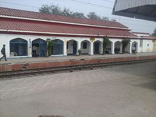
Unnao Junction Railway Station, also known as Unnao Railway Station, is a major railway station located in Unnao district in the Indian state of Uttar Pradesh. It serves Unnao and the surrounding areas. The station falls under the jurisdiction of the Northern Railway zone of the Indian Railways and serves as a crucial transportation hub for the region. Unnao Junction railway station is on the Lucknow–Kanpur Suburban Railway and Varanasi–Kanpur branch line.
Daranagar is a town in Kaushambi, a suburb of Allahabad, in Uttar Pradesh, India. The town is located approximately 17 km to the north of the district headquarters of Manjhanpur and is known for the main Pilgrim Center and it is situated at the bank of the Ganga river. The main attraction in the town is the Daranagar Tirtha, dedicated to Bhagwan Shri Rishabhdev. In addition to these well-known monuments, there are many other temples, such as the Hanuman Temple, Jain Temple, Jwala Devi Temple, Ram Janaki Temple, and Kalbhairav Temple. Daranagar is known for the Shia Jama Masjid Syedwarah and the Sunni Shahi Jama Masjid built by Dara Shikoh, the son of the famous Mughal emperor Shah Jahan.
Bhatauli is an Indian village of Kanpur Dehat district in Uttar Pradesh.It is an adjacent to city Rura, Kanpur Dehat District, Uttar Pradesh, India. Bhatauli is the commercial center of grain and vegetables. It is well known place for potatoes cold storage. Many primary schools are in government sector while many others in private (recognized). Saraswati Gyan Mandir Inter College is also here. Jog Mai is a center of faith. The Shiv Bajrang Dham Kishunpur is 200 metres (660 ft) away.
