
Novo Mesto is a city on a bend of the Krka River in the City Municipality of Novo Mesto in southeastern Slovenia, close to the border with Croatia. The town is traditionally considered the economic and cultural centre of the historical Lower Carniola region.

The Krka is a river in southeastern Slovenia, a right tributary of the Sava. With a length of 94.6 km (58.8 mi), it is the second-longest river flowing in its entirety in Slovenia, following the Savinja.
Krka, d. d., Novo mesto is an international generic pharmaceutical company with headquarters in Novo Mesto, Slovenia. As well as a number of companies and representative offices abroad, Krka also had production and distribution centers in Russia, Poland, Croatia, and Germany. Krka sells products to more than 70 countries.

Košarkarski klub Krka, commonly referred to as KK Krka or simply Krka, is a Slovenian professional basketball team based in Novo Mesto that competes in the Slovenian First League and the ABA League. They play their home games at Leon Štukelj Hall. The club is a founding member and shareholder of the Adriatic Basketball Association.
The Temenica is a river in Slovenia. It is one of the most typical influent streams of Slovenia's karst terrain.
Lešnica is a small village on the left bank of the Krka River in the City Municipality of Novo Mesto in southeastern Slovenia. The area is part of the traditional region of Lower Carniola and is now included in the Southeast Slovenia Statistical Region.
Lutrško Selo is a settlement on the left bank of the Krka River in the City Municipality of Novo Mesto in southeastern Slovenia. The area is part of the traditional region of Lower Carniola and is now included in the Southeast Slovenia Statistical Region.
Otočec is a settlement on the left bank of the Krka River in the City Municipality of Novo Mesto in southeastern Slovenia. The area is part of the traditional region of Lower Carniola and is now included in the Southeast Slovenia Statistical Region.
Žihovo Selo is a settlement on the right bank of the Krka River in the City Municipality of Novo Mesto in southeastern Slovenia. The area is part of the traditional region of Lower Carniola and is now included in the Southeast Slovenia Statistical Region.
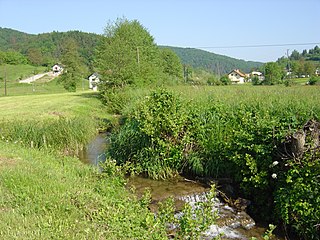
Gorenje Kronovo is a small settlement on the left bank of the Krka River in the City Municipality of Novo Mesto in southeastern Slovenia. The area is part of the traditional region of Lower Carniola and is now included in the Southeast Slovenia Statistical Region.
Gumberk is a settlement in the hills above the right bank of the Krka River in the City Municipality of Novo Mesto in southeastern Slovenia. The area is part of the traditional region of Lower Carniola and is now included in the Southeast Slovenia Statistical Region.

Anton Podbevšek was a Slovenian avant-garde poet. He was an important influence to the poet Srečko Kosovel. He was one of the participants of the artistic activity known as the Novo Mesto Spring in 1920, which marked the beginning of Slovenian modernism. The poet Miran Jarc portrayed him in the semi-autobiographical novel Novo mesto in the character of Andrej Vrezec.
Nogometni klub Krka, commonly referred to as NK Krka or Krka, is a Slovenian football club based in Novo Mesto, that competes in the Slovenian Second League, the second tier of Slovenian football. The team play its home games at Portoval. The club was founded in 1922 and was known as NK Elan in the past.

Moški rokometni klub Krka or simply MRK Krka is a Slovenian handball club from Novo Mesto that competes in the Slovenian First League, the top tier of Slovenian handball.
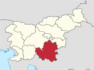
The Southeast Slovenia Statistical Region is a statistical region in southeast Slovenia. It is the largest statistical region. The development of this region is largely the result of industry, which generated nearly half of the gross value added in the region in 2012. According to the latest available data for 2013, 94% of waste water in the region was treated before it was discharged from the public sewage system. This is significantly more than in Slovenia as a whole (78%). The expenditure on research and development (R&D), which amounted to 5.2% of the regional GDP in 2012, highlights the importance of R&D in the region. Businesses accounted for 90% of the sources of financing. The population's age structure in this region is favourable. In mid-2013 the value of the ageing index was 105.2, which means that the ratio between the population 65 or older and the population 15 or less was 105 older people per 100 young people.
Lisca is a 948-metre (3,110 ft) hill in the eastern part of the Sava Hills in southeastern Slovenia, northwest of Sevnica, north of the Sava, and south of Gračnica Creek. It is the most frequently visited hiking destination in the Sava Hills.

Otočec Castle is a castle hotel on a small island in the middle of the Krka River in Otočec, Slovenia. It is the only water castle in Slovenia. The name Otočec means 'small island'. The town of Otočec was renamed in 1952 by the communist government from the religious name Sveti Peter 'Saint Peter' to Otočec, and the castle itself was renamed from its former German name Werth to Otočec.
Portoval is a multi-purpose stadium in Novo Mesto, Slovenia. It is currently used mostly for football matches and is the home ground of NK Krka.


