Dolž is a settlement in the hills southeast of Novo Mesto in southeastern Slovenia, close to the border with Croatia. The entire area is part of the traditional region of Lower Carniola and is now included in the Southeast Slovenia Statistical Region.
Gorenje Grčevje is a small settlement in the hills north of Novo Mesto in southeastern Slovenia. The entire Municipality of Novo Mesto is part of the traditional region of Lower Carniola and is now included in the Southeast Slovenia Statistical Region.
Gornja Težka Voda is a settlement in the foothills of the Gorjanci Range in the Municipality of Novo Mesto in southeastern Slovenia. The area is part of the traditional region of Lower Carniola and is now included in the Southeast Slovenia Statistical Region.
Hrušica is a settlement at the foothills of the Gorjanci Range in the Municipality of Novo Mesto in southeastern Slovenia. The area is part of the traditional region of Lower Carniola and is now included in the Southeast Slovenia Statistical Region.
Koroška Vas is a settlement in the hills south of Novo Mesto in southeastern Slovenia. The area is part of the traditional region of Lower Carniola and is now included in the Southeast Slovenia Statistical Region.
Križe is a settlement in the hills east of the town of Novo Mesto in southeastern Slovenia. The area is part of the traditional region of Lower Carniola and is now included in the Southeast Slovenia Statistical Region.
Zajčji Vrh pri Stopičah is a settlement in the foothills of the Gorjanci range in the Municipality of Novo Mesto in southeastern Slovenia. The area is part of the traditional region of Lower Carniola and is now included in the Southeast Slovenia Statistical Region.
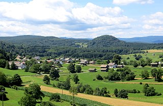
Brezje is a small settlement in the Municipality of Novo Mesto in southeastern Slovenia. It lies in the hills to the south of the main road between Novo Mesto and Šentjernej. The entire municipality is part of the traditional region of Lower Carniola and is now included in the Southeast Slovenia Statistical Region.
Daljni Vrh is a settlement in the hills northwest of the town of Novo Mesto in southeastern Slovenia. The entire Municipality of Novo Mesto lies in the traditional region of Lower Carniola and is now included in the Southeast Slovenia Statistical Region.
Dolenje Karteljevo is a settlement in the hills north of Novo Mesto in southeastern Slovenia. The entire Municipality of Novo Mesto lies in the traditional region of Lower Carniola and is now included in the Southeast Slovenia Statistical Region.
Dolenje Lakovnice is a settlement in the hills south of Novo Mesto in southeastern Slovenia. The entire Municipality of Novo Mesto lies in the traditional region of Lower Carniola and is now included in the Southeast Slovenia Statistical Region.
Gorenje Kamence is a settlement north of the town of Novo Mesto in southeastern Slovenia. The entire Municipality of Novo Mesto is part of the traditional region of Lower Carniola and is now included in the Southeast Slovenia Statistical Region.
Gorenje Karteljevo is a settlement in the hills north of the town of Novo Mesto in southeastern Slovenia. The entire Municipality of Novo Mesto is part of the traditional region of Lower Carniola and is now included in the Southeast Slovenia Statistical Region.
Gorenje Lakovnice is a settlement in the hills south of Novo Mesto in southeastern Slovenia. It includes the small hamlet of Cerovec. The area is part of the traditional region of Lower Carniola and is now included in the Southeast Slovenia Statistical Region.
Jurna Vas is a settlement in the hills south of Novo Mesto in southeastern Slovenia. The area is part of the traditional region of Lower Carniola and is now included in the Southeast Slovenia Statistical Region.
Kuzarjev Kal is a settlement in the hills northwest of Novo Mesto in southeastern Slovenia. The area is part of the traditional region of Lower Carniola and is now included in the Southeast Slovenia Statistical Region.
Leskovec is a settlement in the hills east of Novo Mesto in southeastern Slovenia. The area is part of the traditional region of Lower Carniola and is now included in the Southeast Slovenia Statistical Region.
Male Brusnice is a settlement in the hills east of Novo Mesto in southeastern Slovenia. The area is part of the traditional region of Lower Carniola and is now included in the Southeast Slovenia Statistical Region.
Mali Orehek is a settlement in the foothills of the Gorjanci range in the Municipality of Novo Mesto in southeastern Slovenia. The area is part of the traditional region of Lower Carniola and is now included in the Southeast Slovenia Statistical Region.
Mihovec is a settlement in the hills south of Novo Mesto in southeastern Slovenia. The area is part of the traditional region of Lower Carniola and is now included in the Southeast Slovenia Statistical Region.