Gloucester is a city and the county town of Gloucestershire, United Kingdom. It may also refer to:
The Louisiade Archipelago is a string of ten larger volcanic islands frequently fringed by coral reefs, and 90 smaller coral islands in Papua New Guinea.

Wewak is the capital of the East Sepik province of Papua New Guinea. It is located on the northern coast of the island of New Guinea. It is the largest town between Madang and Jayapura. It is the see city (seat) of the Roman Catholic Diocese of Wewak.
The Ata language, also known as Pele-Ata after its two dialects, or Wasi, is a Papuan language spoken on New Britain island, Papua New Guinea. It appears to be related to neighboring Anêm, and possibly also to Yélî Dnye in a proposed Yele-West New Britain family. There are about 2000 speakers.
Dadibi is a language of Papua New Guinea. In 2001, the whole Bible was translated into Dadibi.

The North Fly District of the Western Province of Papua New Guinea is the northernmost, smallest, and arguably the most remote of the three districts of the province. It contains the Local-Level Government (LLG) areas of Kiunga Rural, Kiunga Urban, Ningerum Rural, Olsobip Rural and Star Mountains Rural, and the townships of Kiunga, Tabubil, Olsobip and Ningerum.

The Middle Fly District of the Western Province of Papua New Guinea is a large, coastal district that forms the central area of the Fly River basin. It contains the Local-Level Government areas of: Balimo Urban, Bamu Rural, Gogodaia Rural, Lake Murray Rural, and Nomad Rural, and the population centres of Balimo, Bamu, Gogodala and Nomad. It also contains the largest lake in the country, Lake Murray.
Kavieng District is the northernmost district of New Ireland Province in Papua New Guinea. The district contains the northern part of the island of New Ireland, as well as New Hannover, and the St. Matthias Group.

Namatanai District is the southernmost and larger of the two districts of New Ireland Province in Papua New Guinea. The district covers the southern part of the island of New Ireland, as well as the Tabar Group, the Lihir Group, the Tanga Islands and the Feni Islands.
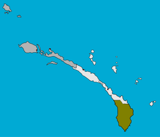
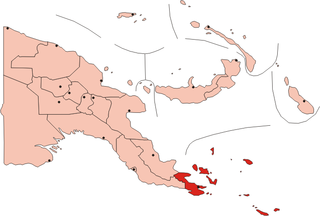
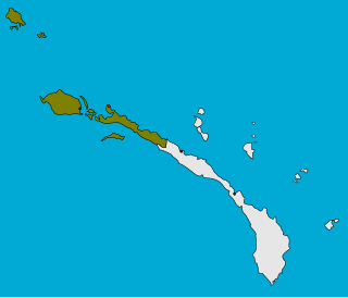
Konoagil Rural LLG is a local government area in New Ireland Province, Papua New Guinea. The LLG administers the southern peninsula of the island of New Ireland. The LLG is located in Namatanai District and its population is 10,503. Languages in the area are Siar-Lak language, Kandas language, and Label language.

This page is a list of districts of Papua New Guinea.

Kandep District is one of the five Districts of Enga Province in Papua New Guinea. It is located in the southern part of Wabag, capital town of Enga. Kandep shares land borders between Laiagam-Porgera district, Wabag, and Wapenamanda District. It also shares borders with Southern Highlands, Western Highlands and the newly breakaway Hela Province. Kandep is accessible by road, and the Kandep - Laiagam Road links to Wabag which is 3 hours drive back and forth. The Kandep - Mendi road, a newly sealed road can be used to travel to Mt. Hagen via Mendi. The Kandep - Magarima Road is also connected.

Kandrian-Gloucester District is a district of the West New Britain Province of Papua New Guinea. Its capital is Kandrian.
Tambul-Nebilyer District is a district of the Western Highlands Province of Papua New Guinea. Its capital is Tambul. The population of the district was 75,499 at the 2011 census. it has 3 LLG wards, they are Nebilyer Rural LLG, Mt. Giluwe Rural LLG and Lower Kaguel Rural LLG. In these district the most beautiful and the second largest mountain called Mt Giluwe is found there.
Bogaya (Pogaya) is a Papuan language of Papua New Guinea. In Western Province, Bogaya is spoken in Olsobip Rural LLG and Nomad Rural LLG. It is also spoken in Koroba-Kopiago District, Hela Province.
Chuave is a Trans–New Guinea language of Chimbu Province and Eastern Highlands Province, Papua New Guinea.
Gorovu is a nearly extinct Ramu language of Papua New Guinea.

Gloucester Rural LLG is a local-level government (LLG) of West New Britain Province, Papua New Guinea.
Kandrian Coastal Rural LLG is a local-level government (LLG) of West New Britain Province, Papua New Guinea.
Kandrian Inland Rural LLG is a local-level government (LLG) of West New Britain Province, Papua New Guinea.
