Kanki, Uttar Dinajpur

Last updated

Kanki
Coordinates: 26°00′22″N87°51′30″E / 26.006140°N 87.858254°E / 26.006140; 87.858254

Kanki is a village under Goalpokhar II community development block in the district of Uttar Dinajpur, West Bengal, India. It is also the center of the Kanki Gram Panchayat. It is famous for historical Jain Mandir Kanki and Ramdev Baba Mandir.

Contents

Features

The village is located in North Dinajpur, a district of West Bengal. It is situated beside NH-31. The population is about 1600, and the town has a railway station named Kanki railway station with trains to the nearest city, Kishanganj. [1] The area has a population of around 12000. Kanki has a church and two nationalised banks (Punjab National Bank and Indian Overseas Bank), with a temple of Shri Krishna Avatar Baba Ramdev, Digambar Jain Mandir and a Mosque considered tourist attractions.

Kanki's daily temperatures tend to coincide with those of Darjeeling, by virtue of their proximity. In summer, temperatures reach 40 °C and can drop as low as 4 °C in the winter.

Gram Panchayat

The Kanki gram panchayat (village council) is the local government for the villages of Basatput, Chaugharia, Dangi, Deogaon, Hathipaon, Hatwar, Kanki, Mahishakhor, Majlispur, Manora, Matiari, Najarpur, Nayanagar, Pachim Lahil, Peazgaon, Sahaspur, Simulia, Suhia, and Suhiasani. [1]

Industry

The majority of the workforce is involved with the agricultural industry. As suits its agricultural focus, Kanki serves as a hub for vegetable exports and Lahil developing in progress.

Education

Here is a High School (Kanki Shree jain Vidya Mandir) with co-education facility up to class XII. There is also a girls' school, offering up to class VIII.

Schools offering primary education in the area include Marigold English school, Simulia f.p. School, Evergreen Public School Kanki, [2] Kanki Public School, Kanki Jr. Basic School, Darul Ulum Mohammadia, Hatwar F.p. School, Basatpur Madrasah Shiksha Kendra, Hatwar Msk, Children Ideal English School, Hatipaon F.p. School, Kanki Colony Ssk, Aljamiatus Sunnia Lahil Manora, Sahapur F.p. School, Mahisakhore Ssk, Manora Urdu Medium F.p.school, Monara High School, Al-jame-atul Ashrafia Garib, Dr. Zakir Hussain Public School, Sani Suhia F.p. School, and Nayanagar Ssk., Al Habib Islamic School [3]

Related Research Articles

<span class="mw-page-title-main">Uttar Dinajpur district</span> District of West Bengal, India

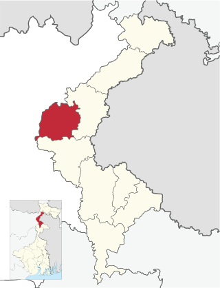
Uttar Dinajpur, also known as North Dinajpur, is a district of the Indian state of West Bengal. Created on 1 April 1992 by the division of the erstwhile West Dinajpur district, it comprises two subdivisions: Raiganj and Islampur.

<span class="mw-page-title-main">Dakshin Dinajpur district</span> District in West Bengal, India

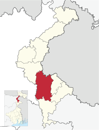
Dakshin Dinajpur, also known as South Dinajpur, is a district in the Indian state of West Bengal, India. It was created on 1 April 1992 by the division of the erstwhile West Dinajpur District.The Headquarter (sadar) of the district is at Balurghat. It comprises two subdivisions: Balurghat and Gangarampur. According to the 2011 census, it is the third least populous district of West Bengal.

<span class="mw-page-title-main">Raiganj</span> City in West Bengal, India

Raiganj is a city and a municipality in the Indian state of West Bengal. It is the headquarters of the Uttar Dinajpur district. The police station was set up 125 years ago and railway connectivity reached the place 115 years ago. The city houses the 111-year-old Raiganj Coronation High School and more than 50-years-old government primary Raiganj Sarala Sundari GSFP School. Raiganj got its railway connection in 1896. The train used to go to Parbatipur junction in Bangladesh from Raiganj. It is a 200-year-old town.

<span class="mw-page-title-main">Dalkhola</span> City in West Bengal, India

Dalkhola is a city and a municipality of Uttar Dinajpur district in the state of West Bengal, India.

<span class="mw-page-title-main">Chopra (community development block)</span> Community development block in West Bengal, India

Chopra is community development block that forms an administrative division in Islampur subdivision of Uttar Dinajpur district in the Indian state of West Bengal.

<span class="mw-page-title-main">Itahar</span> Community development block in West Bengal, India

Itahar is a community development block that forms an administrative division in Raiganj subdivision of Uttar Dinajpur district in the Indian state of West Bengal.

<span class="mw-page-title-main">Goalpokhar I</span> Community development block in West Bengal, India

Goalpokhar I is a community development block that forms an administrative division in Islampur subdivision of Uttar Dinajpur district in the Indian state of West Bengal.

<span class="mw-page-title-main">Karandighi</span> Community development block in West Bengal, India

Karandighi is a community development block that forms an administrative division in Islampur subdivision of Uttar Dinajpur district in the Indian state of West Bengal. Jawahar Navodaya Vidyalaya, Dalkhola, Uttar Dinajpur was established in 2005. The school is temporariliy running at Teest Colony, Dalkhola, Uttar Dinajpur. It is adjacent to Primary Health Center, Dalkhola on NH 34. The land for the construction of permanent building has been transferred and construction work is about to start at Village Sima Anandapur of Panchayat Raniganj. The temporary site is about 3.5 Km from Dalkhola Railway Station.

<span class="mw-page-title-main">Islampur subdivision</span> Subdivision in West Bengal, India

Islampur subdivision is an administrative subdivision of the Uttar Dinajpur district in the Indian state of West Bengal. This subdivision was earlier a part of Bihar and was transferred to West Bengal with the passing of the States Reorganisation Act in 1956.

<span class="mw-page-title-main">Hemtabad</span> Community development block in West Bengal, India

Hemtabad is a community development block that forms an administrative division in Raiganj subdivision of Uttar Dinajpur district in the Indian state of West Bengal.

<span class="mw-page-title-main">Harirampur (community development block)</span> Community development block in West Bengal, India

Harirampur is a community development block that forms an administrative division in Gangarampur subdivision of Dakshin Dinajpur district in the Indian state of West Bengal.

<span class="mw-page-title-main">Tapan (community development block)</span> Community development block in West Bengal, India

Tapan is a community development block that forms an administrative division in Balurghat subdivision of Dakshin Dinajpur district in the Indian state of West Bengal.

Chakulia is a gram panchayat with a police station in Goalpokhar II CD block in Islampur subdivision of Uttar Dinajpur district in the Indian state of West Bengal.

Farsara is the area of Dalkhola Municipality in Ward no.9 and 16. in Uttar Dinajpur District West Bengal

<span class="mw-page-title-main">Balurghat (community development block)</span> Community development block in West Bengal, India

Balurghat is a community development block that forms an administrative division in Balurghat subdivision of Dakshin Dinajpur district in the Indian state of West Bengal.

Goalpokhar is a village in Goalpokhar I CD block in Islampur subdivision of Uttar Dinajpur district in the state of West Bengal, India.

<span class="mw-page-title-main">Goalpokhar II</span> Community development block in West Bengal, India

Goalpokhar II is a community development block that forms an administrative division in Islampur subdivision of Uttar Dinajpur district in the Indian state of West Bengal.

<span class="mw-page-title-main">Islampur, Uttar Dinajpur (community development block)</span> Community development block in West Bengal, India

Islampur is a community development block that forms an administrative division in Islampur subdivision of Uttar Dinajpur district in the Indian state of West Bengal.

<span class="mw-page-title-main">Kaliaganj (community development block)</span> Community development block in West Bengal, India

Kaliaganj is a community development block that forms an administrative division in Raiganj subdivision of Uttar Dinajpur district in the Indian state of West Bengal.

<span class="mw-page-title-main">Raiganj (community development block)</span> Community development block in West Bengal, India

Raiganj is a community development block that forms an administrative division in Raiganj subdivision of Uttar Dinajpur district in the Indian state of West Bengal.

References

  1. 1 2 "Kanki Village in Goalpokhar Ii". Indian Village Directory. Retrieved 31 January 2018.
  2. "Evergreen Public School, Kanki". All India Facts. Retrieved 3 January 2018.
  3. "List of Schools in Goalpokher Ii (Uttar Dinajpur), West Bengal". All India Facts. Retrieved 31 January 2018.