
The Republic of North Ingria, or Republic of Kirjasalo, was a short-lived, small state for the Ingrian Finns in the southern part of the Karelian Isthmus, which seceded from Bolshevist Russia after the October Revolution. Its aim by most proponents was to ultimately be incorporated into the Kingdom of Finland, and it ruled parts of Northern Ingria from 1919 until 1920. With the Peace Treaty of Tartu, it was re-integrated into Russia; however, Ingrian Finns of this area enjoyed a certain degree of national autonomy until the 1930s in compliance with the policy of national delimitation in the Soviet Union. In 1928 the Kuivaisi National District was established there with its administrative base in Toksovo. In 1939 it was abolished and the area was joined to the Pargolovo district. Today, it is the north-eastern part of Vsevolozhsky District.
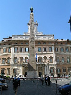
Piazza di Monte Citorio or Piazza Montecitorio is a piazza in Rome. It is named after the Monte Citorio, one of the minor hills of Rome.
Higher Institute of Dramatic Arts was founded in Damascus, Syria in 1977 by some academics such as Saadallah Wannous. The institute heralded a new phase in the development of Syrian theatre and drama which begun with the preparation of the next generation of actors on an academic basis. The Institute includes five departments: Acting, Theatrical Critique, Dramatic Arts, Scenography, and Theatrical Techniques. The Institute has succeeded in rapidly making its mark on the theatre and dramatic arts scene with noted performances being presented in Kuwait, Egypt, Jordan, Lebanon, Germany and many others.

Katarzyniec is a village in the administrative district of Gmina Więcbork, within Sępólno County, Kuyavian-Pomeranian Voivodeship, in north-central Poland. It lies approximately 8 kilometres (5 mi) south of Więcbork, 19 km (12 mi) south of Sępólno Krajeńskie, and 40 km (25 mi) north-west of Bydgoszcz.
Babichy is a village in the administrative district of Gmina Rzgów, within Łódź East County, Łódź Voivodeship, in central Poland. It lies approximately 3 kilometres (2 mi) south-east of Rzgów and 16 km (10 mi) south of the regional capital Łódź.

Barmy is a village in the Agsu Rayon of Azerbaijan.
Mogiła is a village in the administrative district of Gmina Ulhówek, within Tomaszów Lubelski County, Lublin Voivodeship, in eastern Poland, close to the border with Ukraine.
Borowa Góra is a village in the administrative district of Gmina Serock, within Legionowo County, Masovian Voivodeship, in east-central Poland. It lies approximately 5 kilometres (3 mi) south-west of Serock, 12 km (7 mi) north-east of Legionowo, and 30 km (19 mi) north of Warsaw.
Brzezina is a village in the administrative district of Gmina Strzelce Opolskie, within Strzelce County, Opole Voivodeship, in south-western Poland. It lies approximately 4 kilometres (2 mi) south-east of Strzelce Opolskie and 35 km (22 mi) south-east of the regional capital Opole.
Grzampki is a settlement in the administrative district of Gmina Chojnice, within Chojnice County, Pomeranian Voivodeship, in northern Poland. It lies approximately 19 kilometres (12 mi) north of Chojnice and 95 km (59 mi) south-west of the regional capital Gdańsk.
Brzeźno is a village in the administrative district of Gmina Człuchów, within Człuchów County, Pomeranian Voivodeship, in northern Poland. It lies approximately 8 kilometres (5 mi) east of Człuchów and 109 km (68 mi) south-west of the regional capital Gdańsk.
Łówcz Górny is a village in the administrative district of Gmina Łęczyce, within Wejherowo County, Pomeranian Voivodeship, in northern Poland. It lies approximately 12 kilometres (7 mi) south-east of Łęczyce, 21 km (13 mi) south-west of Wejherowo, and 46 km (29 mi) west of the regional capital Gdańsk.
Kusice is a village in the administrative district of Gmina Malechowo, within Sławno County, West Pomeranian Voivodeship, in north-western Poland. It lies approximately 7 kilometres (4 mi) south of Malechowo, 19 km (12 mi) south-west of Sławno, and 156 km (97 mi) north-east of the regional capital Szczecin.

Lapmežciems Parish is an administrative unit of the Engure Municipality, Latvia.

Shen County, or Shenxian, is a county of western Shandong province, People's Republic of China, bordering Henan to the south and southwest and Hebei to the west. It is the southernmost county-level division of the prefecture-level city of Liaocheng.

Seddouk District is a district of Béjaïa Province, Algeria.
Käbiküla is a village in Märjamaa Parish, Rapla County in western Estonia.

Kõruse-Metsaküla is a village in Saaremaa Parish, Saare County in western Estonia.

Cona, also Dongaii Cona or Tsonag Lake, is a major lake of northern Tibet Autonomous Region, China and is It is located in Amdo County, west of the road between Nagqu Town and Amdo Town. The lake is considered holy to the Tibetans especially in the Bon religion, as it is seen as the "soul lake" of the Razheng Living Buddha. The smaller Ganong Lake lies almost adjacent to the southeast.

Boulevard Park is a census-designated place (CDP) in King County, Washington, United States. The population was 5,287 at the 2010 census. Boulevard Park was part of the Riverton-Boulevard Park CDP, until it was split for the 2010 census into Riverton and Boulevard Park.


