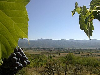
Igantzi is a town and municipality located in the province and autonomous community of Navarre, northern Spain.

Pihtla Parish was a municipality in Saare County, Estonia. The municipality had a population of 1,400 and covered an area of 228.11 km².

Dalverzin Tepe is an ancient archaeological site located in the northern part of the region of Bactria, southern modern Uzbekistan, about 120 km north-east of Termez.

Kanda-Surugadai is a district of Chiyoda, Tokyo, Japan. It was named after Tokugawa Ieyasu's death, when the Edo government allowed officials from Sunpu to live in the area. Their postal code is 101-0062. Kanda-Surugadai is often called Surugadai or, colloquially, Sundai.

Shirakamut is a town in the Lori Province of Armenia. The town was the epicenter of 1988 Armenian earthquake.

Kostry-Litwa is a village in the administrative district of Gmina Nowe Piekuty, within Wysokie Mazowieckie County, Podlaskie Voivodeship, in north-eastern Poland. It lies approximately 5 kilometres (3 mi) west of Nowe Piekuty, 11 km (7 mi) south-east of Wysokie Mazowieckie, and 46 km (29 mi) south-west of the regional capital Białystok.

Gülməmmədli is a village in the Goranboy Rayon of Azerbaijan. The village forms part of the municipality of Qırıqlı.
Donguli is a village in the Khizi Rayon of Azerbaijan.
Aleksandrów is a village in the administrative district of Gmina Ujazd, within Tomaszów Mazowiecki County, Łódź Voivodeship, in central Poland. It lies approximately 17 kilometres (11 mi) north-west of Tomaszów Mazowiecki and 32 km (20 mi) south-east of the regional capital Łódź.
Marszew is a village in the administrative district of Gmina Ujazd, within Tomaszów Mazowiecki County, Łódź Voivodeship, in central Poland. It lies approximately 17 kilometres (11 mi) north-west of Tomaszów Mazowiecki and 32 km (20 mi) south-east of the regional capital Łódź.
Stare Oborzyska is a village in the administrative district of Gmina Kościan, within Kościan County, Greater Poland Voivodeship, in west-central Poland. It lies approximately 5 kilometres (3 mi) north-east of Kościan and 36 km (22 mi) south-west of the regional capital Poznań.
Sobiemirowo is a settlement in the administrative district of Gmina Sławoborze, within Świdwin County, West Pomeranian Voivodeship, in north-western Poland. It lies approximately 5 kilometres (3 mi) south-west of Sławoborze, 11 km (7 mi) north-west of Świdwin, and 88 km (55 mi) north-east of the regional capital Szczecin.
Si County or Sixian is a county in the northeast of Anhui Province, China, bordering Jiangsu province to the north and east. It is under the administration of the prefecture-level city of Suzhou City.
Taouila is a town and commune in Laghouat Province, Algeria. According to the 1998 census it has a population of 2,634.
Todorovce is a village in the municipality of Leskovac, Serbia. According to the 2002 census, the village has a population of 521 people.
Pala is a village in Kuusalu Parish, Harju County in northern Estonia.
Huổi Lèng is a commune (xã) and village of the Mường Chà District of Điện Biên Province, northwestern Vietnam.

Hamri is a town and commune in Relizane Province, Algeria.
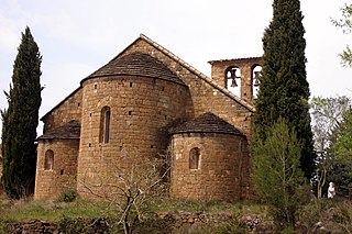
Sant Sepulcre de Palera is a Benedictine monastery in Beuda, in the comarca of Garrotxa, Province of Girona, Catalonia, Spain. The priory was consecrated by Bishop Berengar of Berga in 1085, with the assistance of the bishops of Barcelona, Carcassonne, Albi and Elne. In 1107 it became part of the monastery of Santa Maria de la Grasse until the sixteenth century, when it became a pilgrimage centre known as Santo Domingo de Palera. In 1936 the temple was desecrated and several figures and parts of altarpieces disappeared. It became a Bien de Interés Cultural site on 24 September 1964.

Al-Dana, Maarrat al-Nu'man is a Syrian village located in Maarrat al-Nu'man Nahiyah in Maarrat al-Nu'man District, Idlib. According to the Syria Central Bureau of Statistics (CBS), Al-Dana, Maarrat al-Nu'man had a population of 2607 in the 2004 census.


