
Pylkönmäki is a former municipality of Finland. It was consolidated to Saarijärvi on 1 January 2009.

Bembèrèkè is a town, arrondissement, and commune located in the Borgou Department of Benin. The commune covers an area of 3348 square kilometres and as of 2012 had a population of 31,101 people.

Hatvan is a town in Heves county, Hungary. Hatvan is the Hungarian word for "sixty". Hatvan is located at around 47°40′5″N19°40′11″E.

The Kerinchi LRT station is a rapidKL Kelana Jaya LRT station in Kuala Lumpur. The station, which is named after Kampung Kerinchi, a village within walking distance, is located inside Plaza Pantai, a mixed commercial complex near Jalan Pantai Baru.
Hyōgo Station is a railway station in Hyōgo-ku, Kobe, Hyōgo Prefecture, Japan, operated by the West Japan Railway Company.
Leonowo is a village in the administrative district of Gmina Osięciny, within Radziejów County, Kuyavian-Pomeranian Voivodeship, in north-central Poland.

Miklesz-Kolonia is a village in the administrative district of Gmina Złoczew, within Sieradz County, Łódź Voivodeship, in central Poland. It lies approximately 2 kilometres (1 mi) south-east of Złoczew, 23 km (14 mi) south of Sieradz, and 72 km (45 mi) south-west of the regional capital Łódź.
Strugi Krzywickie is a village in the administrative district of Gmina Siennica, within Mińsk County, Masovian Voivodeship, in east-central Poland.
Wygnanka is a village in the administrative district of Gmina Mszczonów, within Żyrardów County, Masovian Voivodeship, in east-central Poland. It lies approximately 12 kilometres (7 mi) south-east of Mszczonów, 23 km (14 mi) south-east of Żyrardów, and 44 km (27 mi) south-west of Warsaw.
Józefowo is a village in the administrative district of Gmina Babiak, within Koło County, Greater Poland Voivodeship, in west-central Poland. It lies approximately 3 kilometres (2 mi) north of Babiak, 19 km (12 mi) north of Koło, and 120 km (75 mi) east of the regional capital Poznań.
Biernatka is a village in the administrative district of Gmina Czarne, within Człuchów County, Pomeranian Voivodeship, in northern Poland. It lies approximately 11 kilometres (7 mi) east of Czarne, 18 km (11 mi) west of Człuchów, and 127 km (79 mi) south-west of the regional capital Gdańsk.
Dychlino is a settlement in the administrative district of Gmina Wicko, within Lębork County, Pomeranian Voivodeship, in northern Poland. It lies approximately 9 kilometres (6 mi) north of Wicko, 23 km (14 mi) north of Lębork, and 77 km (48 mi) north-west of the regional capital Gdańsk.
Malczewo is a village in the administrative district of Gmina Bierzwnik, within Choszczno County, West Pomeranian Voivodeship, in north-western Poland. It lies approximately 7 kilometres (4 mi) north of Bierzwnik, 18 km (11 mi) south-east of Choszczno, and 79 km (49 mi) south-east of the regional capital Szczecin.
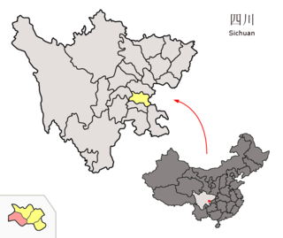
Weiyuan County is a county of Sichuan Province, China. It is under the administration of Neijiang City. The county borders Neijiang, Zigong, Rongxian, Zizhong and Renshou. It administers 20 townships.

Sunnynook is a hamlet in southern Alberta, Canada within Special Area No. 2. It is located approximately 10 kilometres (6.2 mi) east of Highway 36 and 86 kilometres (53 mi) northeast of Brooks. The hamlet formerly housed the Berry Creek Community School Division office and area post office until amalgamation of the school division into Prairie Land Regional Division.

Lukomir is a village in the municipality of Žitorađa, Serbia. According to the 2002 census, the village has a population of 960 people.
Haeska is a village in Saaremaa Parish, Saare County in western Estonia.

Thorncross is a small hamlet in the South West of the Isle of Wight, England.. It is located near the hamlet of Yafford and the village of Brighstone.
Mikes is a census-designated place (CDP) in Starr County, Texas, United States. This was a new CDP for the 2010 census with a population of 910.

Tunca Brige is a historic bridge in Turkey.


