
The Dell Dimension series was a line of home and business desktop computers manufactured by Dell. In 2007, the Dimension series was discontinued and replaced with the Dell Inspiron series for low-end models and the Dell Studio series for higher-end models.

Al Mahrah, or simply Mahra, is a governorate (muhafazah) of Yemen in the southern part of the Arabian Peninsula. Situated in the area of the former Mahra Sultanate, its capital is Al Ghaydah, and it has international borders with Saudi Arabia and Oman.
Zweeloo is a village in the municipality of Coevorden, located in the province of Drenthe, The Netherlands.
Esplús is a municipality located in the province of Huesca, Aragon, Spain. According to the 2004 census (INE), the municipality has a population of 733 inhabitants.
Bernburg was a Verwaltungsgemeinschaft in the Salzlandkreis district, in Saxony-Anhalt, Germany. The seat of the Verwaltungsgemeinschaft was in Bernburg. It was disbanded on 1 January 2010.
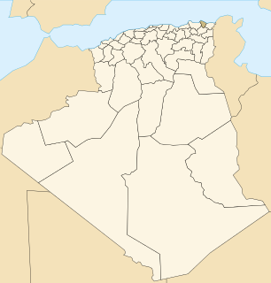
El Hadjar is a district in Annaba Province, Algeria. It was named after its capital, El Hadjar.

El Hadjar is a town in north-eastern Algeria.

Bilciurești is a commune in Romania. It is located in Dâmbovița County. It is composed of two villages, Bilciurești and Suseni-Socetu.

Pruszanka Stara is a village in the administrative district of Gmina Brańsk, within Bielsk County, Podlaskie Voivodeship, in north-eastern Poland. It lies approximately 9 kilometres (6 mi) north-west of Brańsk, 32 km (20 mi) west of Bielsk Podlaski, and 46 km (29 mi) south-west of the regional capital Białystok.
Beica de Jos is a commune in Mureș County, Transylvania, Romania. It is composed of six villages: Beica de Jos, Beica de Sus (Felsőbölkény), Căcuciu (Görgénykakucs), Nadășa (Görgénynádas), Sânmihai de Pădure (Szentmihály) and Șerbeni (Soropháza).

Moruxlu is a village in the Gadabay Rayon of Azerbaijan. The village forms part of the municipality of Samanlıq.
Biniew is a village in the administrative district of Gmina Ostrów Wielkopolski, within Ostrów Wielkopolski County, Greater Poland Voivodeship, in west-central Poland. It lies approximately 12 kilometres (7 mi) north-east of Ostrów Wielkopolski and 96 km (60 mi) south-east of the regional capital Poznań.
Załęże is a village in the administrative district of Gmina Koniecpol, within Częstochowa County, Silesian Voivodeship, in southern Poland. It lies approximately 4 kilometres (2 mi) north-east of Koniecpol, 44 km (27 mi) east of Częstochowa, and 81 km (50 mi) north-east of the regional capital Katowice.
Pustkowie is a settlement in the administrative district of Gmina Herby, within Lubliniec County, Silesian Voivodeship, in southern Poland. It lies approximately 10 kilometres (6 mi) north-east of Lubliniec and 56 km (35 mi) north of the regional capital Katowice.
Odra is a village in the administrative district of Gmina Nowa Sól, within Nowa Sól County, Lubusz Voivodeship, in western Poland.

Tambaga is a village and rural commune in the Cercle of Kita in the Kayes Region of south-western Mali. The commune contains 10 villages and in the 2009 census had a population of 11,152.
Sătmărel is a residential district of Satu Mare in Romania. Legally a village administered by the city, it was a separate commune until the 1980s.

Mijovce is a village in the municipality of Vranje, Serbia. According to the 2002 census, the village has a population of 67 people.
German submarine U-733 was a Type VIIC U-boat of Nazi Germany's Kriegsmarine during World War II. The submarine was laid down on 15 October 1941 at the Schichau-Werke yard at Danzig, launched on 5 September 1942, and commissioned on 14 November 1942 under the command of Oberleutnant zur See Wilhelm von Trotha.
German submarine U-3503 was a Type XXI U-boat of Nazi Germany's Kriegsmarine, built for service in World War II. She was ordered on 6 November 1943, and was laid down on 17 June 1944 at F Schichau GmbH, Danzig, as yard number 1648. She was launched on 27 July 1944, and commissioned under the command of Oberleutnant zur See Hugo Deiring, on 9 September 1944.


