Mali, officially the Republic of Mali, is a landlocked country in West Africa, a region geologically identified with the West African Craton. Mali is the eighth-largest country in Africa, with an area of just over 1,240,000 square kilometres (480,000 sq mi). The population of Mali is 18 million. Its capital is Bamako. The sovereign state of Mali consists of eight regions and its borders on the north reach deep into the middle of the Sahara Desert, while the country's southern part, where the majority of inhabitants live, features the Niger and Senegal rivers. The country's economy centers on agriculture and mining. Some of Mali's prominent natural resources include gold, being the third largest producer of gold in the African continent, and salt.
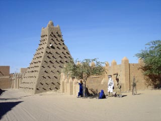
Timbuktu is an ancient city in Mali, situated 20 km (12 mi) north of the Niger River. The town is the capital of the Timbuktu Region, one of the eight administrative regions of Mali. It had a population of 54,453 in the 2009 census.
An administrative centre is a seat of regional administration or local government, or a county town, or the place where the central administration of a commune is located.

Niéna is a small town and rural commune in the Cercle of Sikasso in the Sikasso Region of southern Mali. The commune covers an area of 1,040 square kilometers and includes the town and 42 villages. In the 2009 census it had a population of 32,265. The town is the administrative center (chef-lieu) of the commune. It is 76 km west of Sikasso on the RN7, the main road linking Sikasso and Bougouni.
Yorosso is a town and rural commune in the Yorosso Cercle, in the Sikasso Region of southern Mali. The town serves as the seat of the Yorosso Cercle. It lies 151 km northeast of Sikasso and 202 km southeast of Ségou. The commune covers an area of 487 square kilometers, and includes the Yorosso town and nine other surrounding villages. According to the 2009 census, it had a population of 22,063.

Mali Zvornik is a town and municipality located in the Mačva District of western Serbia. In 2011, the population of the town is 4,132, while the population of the municipality is 11,987. It lays opposite of the Drina river from the town of Zvornik, in Bosnia and Herzegovina.

A Commune is the third level administrative unit in Mali. Mali is divided into eight regions and one capital district (Bamako). These subdivisions bear the name of their principal city. The regions are divided into 49 Cercles. The Cercles and the district are divided into 703 Communes, with 36 Urban Communes and 667 Rural Communes, while some larger Cercles still contain Arrondissements above the Commune level, these are organisational areas with no independent power or office. Rural Communes are subdivided in Villages, while Urban Communes are subdivided into Quartier. Communes usually bear the name of their principal town. The capital, Bamako, consists of six Urban Communes. There were initially 701 communes until the Law No. 01-043 of 7 June 2001 created two new Rural Communes in the desert region in the north east of the country: Alata, Ménaka Cercle in the Gao Region and Intadjedite, Tin-Essako Cercle in the Kidal Region.
Tambaga is a village and rural commune in the Cercle of Kita in the Kayes Region of south-western Mali. The commune contains 10 villages and in the 2009 census had a population of 11,152.
Kadiolo is a town, rural commune and seat of the Kadiolo Cercle in the Sikasso Region of southern Mali. The town lies 85 km south of Sikasso, 13 km north of the border with the Ivory Coast and 30 km west of the border with Burkino Faso. The commune of Kadiolo covers an area of 783 square kilometers and includes the town and 19 villages. In the 2009 census it had a population of 59,932.
Sincina is a small town and commune in the Cercle of Koutiala in the Sikasso Region of southern Mali. The commune covers an area of 210 square kilometers and includes 7 settlements. In the 2009 census it had a population of 17,025. The town of Sincina, the administrative centre (chef-lieu) of the commune, is only 5 km southeast of the center of Koutiala. As Koutiala expands the commune will become a suburb of the town.
Lobougoula is a small town and rural commune in the Cercle of Sikasso in the Sikasso Region of southern Mali. The commune covers an area of 1418 square kilometers and includes the town and 31 villages. In the 2009 census it had a population of 32,505. The town of Lobougoula, the chef-lieu of the commune, is 49 km southwest of Sikasso.
Kignan is a small town and rural commune in the Cercle of Sikasso in the Sikasso Region of southern Mali. The commune covers an area of 646 square kilometers and includes the town and 14 villages. As of the 2009 census it had a population of 33,962. The town of Kignan is 77 km northwest of Sikasso on the R20 road that links Sikasso to Fana.
Fama is a small town and rural commune in the Cercle of Sikasso in the Sikasso Region of southern Mali. The commune covers an area of 222 square kilometers and includes the town and five villages. In the 2009 census it had a population of 7,960. The town of Fama, the chef-lieu of the commune, is 24 km north of Sikasso.
Koury is a small town and rural commune in the Cercle of Yorosso in the Sikasso Region of southern Mali. The commune covers an area of 712 square kilometers and includes the town and 16 villages. In the 2009 census it had a population of 54,435. The town, the administrative center (chef-lieu) of the commune, is 19 km south of Yorosso on the main road linking Koutiala in Mali with the town of Bobo-Dioulasso in Burkina Faso.
Kofan is a rural commune in the Cercle of Sikasso in the Sikasso Region of southern Mali. The commune covers an area of 283 square kilometers and includes a small town and 7 villages. In the 2009 census it had a population of 10,236. The administrative center of the commune, the chef-lieu, is the small town of Kafana. The town is 68 km northwest of Sikasso.
Wassoulou-Ballé is a rural commune in the Cercle of Yanfolila in the Sikasso Region of southern Mali. The administrative center (chef-lieu) of the commune is the town of Yanfolila. The town is also the administrative center of the cercle. It lies 272 km west of Sikasso, 164 km south of Bamako and 23 km from the border with Guinea. The commune covers an area of 1,594 square kilometers and includes the town of Yanfolila and 29 villages. In the 2009 census it had a population of 51,727.
Konna is a town and rural commune in the Cercle of Mopti in the Mopti Region of Mali. The town lies 60 km northeast of Mopti on the eastern edge of the flood plain of the Niger River. The main RN16 highway linking Sévaré and Gao branches to the east just to the south of the town. The commune has an area of approximately 838 km2 and contains the town and 24 of the surrounding villages. In the 2009 census it had a population of 36,767.

The Tuareg Rebellion of 2012 was an early stage of the Northern Mali conflict; from January to April 2012, a war was waged against the Malian government by rebels with the goal of attaining independence for the northern region of Mali, known as Azawad. It was led by the National Movement for the Liberation of Azawad (MNLA) and was part of a series of insurgencies by traditionally nomadic Tuaregs which date back at least to 1916. The MNLA was formed by former insurgents and a significant number of heavily armed Tuaregs who fought in the Libyan Civil War.

The Northern Mali Conflict, Mali Civil War, or Mali War refers to armed conflicts that started from January 2012 between the northern and southern parts of Mali in Africa. On 16 January 2012, several insurgent groups began fighting a campaign against the Malian government for independence or greater autonomy for northern Mali, an area of northern Mali they called Azawad. The National Movement for the Liberation of Azawad (MNLA), an organization fighting to make this area of Mali an independent homeland for the Tuareg people, had taken control of the region by April 2012.