Kanyembo

Last updated

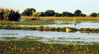
Kanyembo is the principal centre of the population on the Mofwe Lagoon, the largest of several lagoons in the Luapula River swamps south of Lake Mweru, in the Luapula Province of Zambia. It takes its name from its traditional ruler, Chief Kanyembo, one of the senior chiefs of the Kazembe-Lunda under Mwata Kazembe. In the past the incumbent Chief has been promoted to Mwata, and Kanyembo was the site of Mwata Kazembe's capital when it was visited by David Livingstone in 1867.

The Mofwe Lagoon is the largest of several lagoons in the Luapula River swamps south of Lake Mweru, in the Luapula Province of Zambia.

Luapula River river

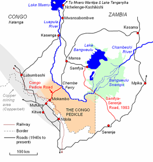
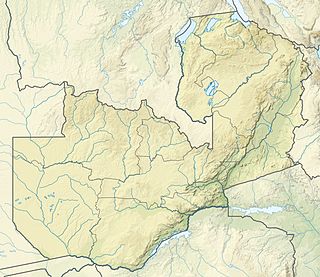
The Luapula River is a section of Africa's second-longest river, the Congo. It is a transnational river forming for nearly all its length part of the border between Zambia and the DR Congo. It joins Lake Bangweulu to Lake Mweru and gives its name to the Luapula Province of Zambia.

Lake Mweru lake in Zambia

Lake Mweru is a freshwater lake on the longest arm of Africa's second-longest river, the Congo. Located on the border between Zambia and Democratic Republic of the Congo, it makes up 110 km of the total length of the Congo, lying between its Luapula River (upstream) and Luvua River (downstream) segments.

Kanyembo lies on the main artery of Luapula Province, the tarred road known as the Zambia Way, linking it to Nchelenge-Kashikishi in the north and Mwansabombwe and Mansa in the south. The villages lining the edge of the Luapula swamps and the south-eastern shore of Lake Mweru merge into each other in an almost unbroken sequence, as happens with Kanyembo and Shanyemba to its north, so the visitor can scarcely distinguish where one ends and the other begins.

Nchelenge City in Luapula Province, Zambia

Nchelenge is a town in the Luapula Province of northern Zambia, lying on the south eastern shore of Lake Mweru. It is contiguous with Kashikishi, and they are sometimes referred to as Nchelenge-Kashikishi. Nchelenge is the administrative centre for the Zambian part of Lake Mweru, being the seat of the district government and branches of national agencies, while Kashikishi is the market and fisheries centre.

Kashikishi is a town on the south-eastern shore of Lake Mweru in the Luapula Province of Zambia. It lies just north of the district headquarters Nchelenge, and close enough for them to be considered twin towns; they are sometimes referred to as Nchelenge–Kashikishi.

Kazembe (Mwansabombwe) Place in Luapula Province, Zambia

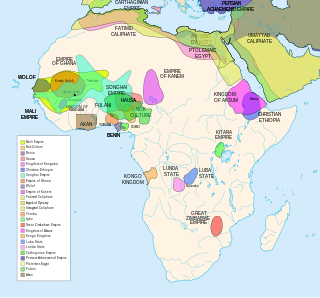
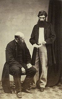
Kazembe is a name used for Mwata Kazembe's town in the Luapula Province of Zambia, especially on maps and in the Zambian postal service. However, the correct name for the town is Mwansabombwe and this is the one used by its or Luba or Chibemba-speaking inhabitants. They may refer in English to "Kazembe's Village" or just "Kazembe", as traditionally a settlement is named after the chief or headman, rather than the location. The Luba-Lunda shared with many tribes the custom of moving to another village or a new site on the death of the chief. Historical references to a village or town may actually be to a different location. For instance when the explorer David Livingstone visited Mwata Kazembe in 1867 and 1868, "Casembe's town", as he wrote it, was further north at the town now called Kanyembo.

The principal activity is fishing, and the hinterland supports farming. Extensive cassava gardens lie on the eastern side. As well as the large mango trees typical of traditional villages in northern Zambia, a notable feature of the Kanyembo area is mature oil palms, which are not native and do not occur naturally elsewhere in Zambia. Although there is no traditional story of their introduction, they were native to the Lunda Kingdom 300 km west from where the Lunda-Kazembe migrated.

Mango fruit, use Q3919027 for the species; Q161807 for the genus

Mangoes are juicy stone fruit (drupe) from numerous species of tropical trees belonging to the flowering plant genus Mangifera, cultivated mostly for their edible fruit.

Related Research Articles

Lake Bangweulu lake

Bangweulu — 'where the water sky meets the sky' — is one of the world's great wetland systems, comprising Lake Bangweulu, the Bangweulu Swamps and the Bangweulu Flats or floodplain. Situated in the upper Congo River basin in Zambia, the Bangweulu system covers an almost completely flat area roughly the size of Connecticut or East Anglia, at an elevation of 1,140 m straddling Zambia's Luapula Province and Northern Province. It is crucial to the economy and biodiversity of northern Zambia, and to the birdlife of a much larger region, and faces environmental stress and conservation issues.

Luapula Province Province in Zambia

Luapula Province is one of Zambia's ten provinces located in the northern part of the country. Luapula Province is named after the Luapula River and its capital is Mansa. As per the 2010 Zambian census, the Province had a population of 991,927, which accounted for 7.57 per cent of the total Zambian population.

Kingdom of Lunda pre-colonial African confederation of states in what is now the Democratic Republic of Congo, Angola and Zambia

The Nation of Lunda was a confederation of states in what is now the Democratic Republic of Congo, north-eastern Angola, and north-western Zambia, its central state was in Katanga.

Lunda people ethnic group

The Lunda originated in what is now the Democratic Republic of the Congo along the Kalanyi River and formed the Kingdom of Lunda in the 17th century under their ruler, Mwata Yamvo or Mwaant Yav, with their capital at Musumba. From there they spread widely through Katanga and into Eastern Angola, north-western Zambia and the Luapula valley of Zambia.

The Lunda people of the Luapula River valley in Zambia and DR Congo are called by others the Eastern Lunda to distinguish them from the 'western' Lunda people who remained in the heartland of the former Lunda Kingdom, but they themselves would use Kazembe-Lunda or Luunda with an elongated 'u' to make that distinction..

Mbereshi human settlement in Zambia

Mbereshi is a village in the Luapula Province of Zambia, named after the Mbereshi River on its north side. It is the site of a large mission founded in 1900 by the London Missionary Society. In 1915 the mission established the first girls' school in the territory, as well as a boys' school and a large hospital. The Girls school and Hospital are now Grant Aided institutions run by The United Church of Zambia. Mbereshi contains a number of examples of mission buildings, including a large church which is now part of the United Church of Zambia.

Congo Pedicle road

The Congo Pedicle road crosses the Congolese territory of the Congo Pedicle and was constructed by and is maintained by Zambia to connect its Copperbelt and Luapula Provinces. Both the road and the territory may be referred to as ‘the Pedicle’.

Water transport. and the many navigable inland waterways, in Zambia has a long tradition of practical use in Zambia except in parts of the south. Since draught animals such as oxen were not heavily used, water transport was usually the only alternative to going on foot until the 19th Century. The history and current importance of Zambian waterways, as well as the types of indigenous boats used, provide information on this important aspect of Zambian economy.

Outline of Zambia Overview of and topical guide to Zambia

The following outline is provided as an overview of and topical guide to Zambia:

Zambia, officially known as the Republic of Zambia, is a landlocked country in Southern Africa. The neighbouring countries are the Democratic Republic of the Congo to the north, Tanzania to the north-east, Malawi to the east, Mozambique, Zimbabwe, Botswana, and Namibia to the south, and Angola to the west. The capital city is Lusaka, located in the southeast of the country. The population is concentrated mainly around the capital and the Copperbelt to the northwest.

Nchelenge District District in Luapula Province, Zambia

Nchelenge District is a district of Zambia, located in the Luapula Province. The capital lies at Nchelenge. As of the 2000 Zambian Census, the district had a population of 111,119 people.

Bwile people

The Bwile people are an ethnic group that live in the Democratic Republic of the Congo (DRC) and Zambia around the northern part of Lake Mweru.

Lusenga Plain National Park national park in Zambia

Lusenga Plain National Park is a national park in the Kawambwa District, Luapula Province of Zambia, to the south-east of Lake Mweru.

The Ishindi-Lunda are an ethnic group living mainly in the North-Western Province of Zambia under Senior Chief Ishindi, around the provincial capital Zambezi. The Lunda people of North-Western Province consists of Kanongesha Lunda and Ishindi Lunda.

References

David Livingstone Scottish explorer and missionary

David Livingstone was a Scottish physician, Congregationalist, and pioneer Christian missionary with the London Missionary Society, an explorer in Africa, and one of the most popular British heroes of the late 19th-century Victorian era. He had a mythical status that operated on a number of interconnected levels: Protestant missionary martyr, working-class "rags-to-riches" inspirational story, scientific investigator and explorer, imperial reformer, anti-slavery crusader, and advocate of commercial and colonial expansion.

Horace Waller (activist) English anti-slavery activist, missionary and clergyman

Horace Waller (1833–1896) was an English anti-slavery activist, missionary and clergyman. He was known as a writer on Africa, evangelical Christian, close associate of David Livingstone and others involved in central and east African mission and exploration work, and advocate of British imperial expansion.

Coordinates: 9°35′S28°44′E / 9.583°S 28.733°E / -9.583; 28.733

Geographic coordinate system Coordinate system

A geographic coordinate system is a coordinate system that enables every location on Earth to be specified by a set of numbers, letters or symbols. The coordinates are often chosen such that one of the numbers represents a vertical position and two or three of the numbers represent a horizontal position; alternatively, a geographic position may be expressed in a combined three-dimensional Cartesian vector. A common choice of coordinates is latitude, longitude and elevation. To specify a location on a plane requires a map projection.