
Lake Mweru is a freshwater lake on the longest arm of Africa's second-longest river, the Congo. Located on the border between Zambia and Democratic Republic of the Congo, it makes up 110 kilometres (68 mi) of the total length of the Congo, lying between its Luapula River (upstream) and Luvua River (downstream) segments.

The Luapula River is a north-flowing river of central Africa, within the Congo River watershed. It rises in the wetlands of Lake Bangweulu (Zambia), which are fed by the Chambeshi River. The Luapula flows west then north, marking the border between Zambia and the Democratic Republic of the Congo before emptying into Lake Mweru. The river gives its name to Zambia's Luapula Province.
The pre-colonial history of the modern-day Democratic Republic of the Congo encompasses the history of the Congo Basin region up to the establishment of European colonial rule in the era of New Imperialism and particularly the creation of the Congo Free State and its expansion into the interior after 1885. As the modern territorial boundaries of the Democratic Republic of the Congo did not exist in this period, it is inseparable from the wider pre-colonial histories of Central Africa, the Great Lakes and Rift Valley as well as the Atlantic World and Swahili coast.
Nchelenge is a town in the Luapula Province of northern Zambia, lying on the south eastern shore of Lake Mweru. It is contiguous with Kashikishi, and they are sometimes referred to as Nchelenge-Kashikishi. Nchelenge is the administrative centre for the Zambian part of Lake Mweru, being the seat of the district government and branches of national agencies, while Kashikishi is the market and fisheries centre.
Kawambwa is a town in the Zambian province of Luapula located on the edge of the northern Zambian plateau above the Luapula valley at an altitude of 1300 m. It was chosen as an administrative district of the same name by the British colonial authorities who preferred the climate of the plateau rather than the hotter valley where most of the district's population live, and it continues as an administrative district today.

Luapula Province is one of Zambia's ten provinces located in the northern part of the country. Luapula Province is named after the Luapula River and its capital is Mansa. As per the 2022 Zambian census, the Province had a population of 1,519,478, which accounted for 7.72 per cent of the total Zambian population.

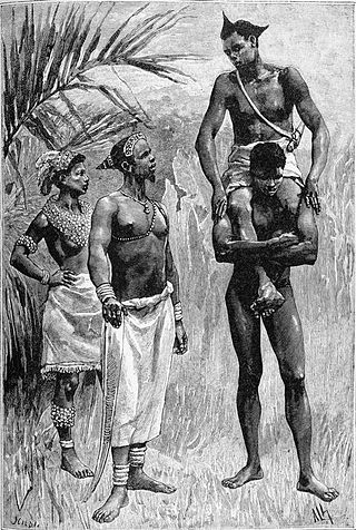
Kazembe is a traditional kingdom in modern-day Zambia, and southeastern Congo. For more than 250 years, Kazembe has been an influential kingdom of the Kiluba-Chibemba, speaking the language of the Eastern Luba-Lunda people of south-central Africa. Its position on trade routes in a well-watered, relatively fertile and well-populated area of forestry, fishery and agricultural resources drew expeditions by traders and explorers who called it variously Kasembe, Cazembe and Casembe.

The Nation of Lunda was a confederation of states in what is now the Democratic Republic of Congo, north-eastern Angola, and north-western Zambia. Its central state was in Katanga.
Kashikishi is a town on the south-eastern shore of Lake Mweru in the Luapula Province of Zambia. It lies just north of the district headquarters Nchelenge, and close enough for them to be considered twin towns; they are sometimes referred to as Nchelenge–Kashikishi.
The Lunda are a Bantu ethnic group that originated in what is now the Democratic Republic of the Congo along the Kalanyi River and formed the Kingdom of Lunda in the 17th century under their ruler, Mwata Yamvo or Mwaant Yav, with their capital at Musumba. From there they spread widely through Katanga and into Eastern Angola, north-western Zambia and the Luapula valley of Zambia.
Kanyembo is the principal centre of the population on the Mofwe Lagoon, the largest of several lagoons in the Luapula River swamps south of Lake Mweru, in the Luapula Province of Zambia. It takes its name from its traditional ruler, Chief Kanyembo, one of the senior chiefs of the Kazembe-Lunda under Mwata Kazembe. In the past the incumbent Chief has been promoted to Mwata, and Kanyembo was the site of Mwata Kazembe's capital when it was visited by David Livingstone in 1867.
The Mofwe Lagoon is the largest of several lagoons in the Luapula River swamps south of Lake Mweru, in the Luapula Province of Zambia.
Mbereshi is a village in the Luapula Province of Zambia, named after the Mbereshi River on its north side. It is the site of a large mission founded in 1900 by the London Missionary Society. In 1915 the mission established Mbereshi Girls' School, the first girls' school in the territory, as well as a boys' school and a large hospital. The Girls school and Hospital are now Grant Aided institutions run by The United Church of Zambia. Mbereshi contains a number of examples of mission buildings, including a large church which is now part of the United Church of Zambia.

The Congo Pedicle road crosses the Congolese territory of the Congo Pedicle and was constructed by and is maintained by Zambia to connect its Copperbelt and Luapula Provinces. Both the road and the territory may be referred to as ‘the Pedicle’. It is designated as the N36 Route on the Congolese Road Network.

Chilubi District with headquarters at Chilubi is located in Northern Province, Zambia. It covers the north-east Lake Bangweulu and Bangweulu Wetlands containing several islands including Chilubi Island, and some of the mainland northeast of the lake. As of the 2000 Zambian Census, the district had a population of 66,338 people.

The following outline is provided as an overview of and topical guide to Zambia:
Zambia, officially known as the Republic of Zambia, is a landlocked country in Southern Africa. The neighbouring countries are the Democratic Republic of the Congo to the north, Tanzania to the north-east, Malawi to the east, Mozambique, Zimbabwe, Botswana, and Namibia to the south, and Angola to the west. The capital city is Lusaka, located in the southeast of the country. The population is concentrated mainly around the capital and the Copperbelt to the northwest.

The Yeke Kingdom of the Garanganze people in Katanga, DR Congo, was short-lived, existing from about 1856 to 1891 under one king, Msiri, but it became for a while the most powerful state in south-central Africa, controlling a territory of about half a million square kilometres. The Yeke Kingdom also controlled the only trade route across the continent from east to west, since the Kalahari Desert and Lozi Kingdom in the south and the Congo rainforest in the north blocked alternative routes. It achieved this control through natural resources and force of arms—Msiri traded Katanga's copper principally, but also slaves and ivory, for gunpowder and firearms—and by alliances through marriage. The most important alliances were with Portuguese–Angolans in the Benguela area, with Tippu Tip in the north and with Nyamwezi and Swahili traders in the east, and indirectly with the Sultan of Zanzibar who controlled the east coast traders.
The M3 road is a road in northern Zambia that connects Kasama in the Northern Province with the Congo Pedicle border at Chembe in the Luapula Province via Luwingu and Mansa. The road contains two tollgates between Kasama and Mansa.
