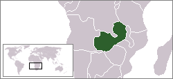
Kazembe is a traditional kingdom in modern-day Zambia, and southeastern Congo. For more than 250 years, Kazembe has been an influential kingdom of the Kiluba-Chibemba, speaking the language of the Eastern Luba-Lunda people of south-central Africa[1] (also known as the Luba, Luunda, Eastern Luba-Lunda, and Luba-Lunda-Kazembe). Its position on trade routes in a well-watered, relatively fertile and well-populated area of forestry, fishery and agricultural resources[1] drew expeditions by traders and explorers (such as Scottish missionary David Livingstone[2]) who called it variously Kasembe, Cazembe and Casembe.
Known by the title Mwata Yav now equivalent to 'Paramount Chief'or King, the monarchy with its annual Mutomboko festival stands out in the Luapula Valley and Lake Mweru in present-day Zambia, though its history in colonial times is an example of how Europeans divided traditional kingdoms and tribes without regard to the consequences.
History
Pre-colonial history
Origin of the Luba-Lunda-Kazembe
List of Mwata Kazembe Chiefs
Italics indicate approx dates
1740–5
I Ng'anga Bilonda
1745–60
II Kanyembo Mpemba
Continued below in the section
to which their rule relates
Around 1740 the first Mwata, Ng'anga Bilonda of the Luba-Lunda Kingdom headed by Mwata Yamvo (or 'Mwaant Yav') 300km west of the Luapula in the DR Congo, left with a group of followers in pursuit eastwards of one Mutanda who had murdered his father Chinyanta and uncle by drowning them in the Mukelweji River.[1] 'Mwata' was originally a title equivalent to 'General', the first of the Mwata Kazembe line were warriors.[2]
After Mutanda had been dealt with, the group continued the eastward migration under Mwata Kazembe II Kanyembo Mpemba, crossing the Luapula River at Matanda, conquering the indigenous people known as the Shila in the Luapula Valley, and setting up Luba or Lunda aristocrats as chiefs over them.[3] Though bringing Lunda and Luba customs and culture (such as the Luba style of ceremonial chieftainship), they adopted the language of the Bemba, a tribe that had also migrated from the Congo and to which they were allied.[1]
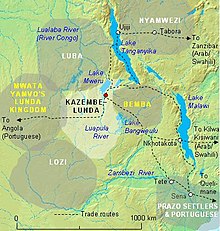
The kingdom prospered from the fisheries of Lake Mweru and the Mofwe Lagoon, and natural resources, including copper ore in Katanga, west of the Luapula.[4] Mwata Kazembe was said by the Portuguese to be able to raise a force of 20,000 men, and his lands stretched west to the Lualaba River (the border with Mwata Yamvo's western Luba-Lunda kingdom and with the other Luba's kingdoms north of that) and east to the Luba-Bemba country.[2] (See the map below.)
Portuguese expeditions
1760–1805
III Lukwesa Ilunga
1805–1850
IV Kanyembo Keleka Mayi
1850–1854
V Kapumba Mwongo Mfwama
In addition to trading with the interior, the Portuguese hoped to establish a route through it connecting their territories of Angola in the west and Mozambique in the east.[5]
The Kazembe kingdom in its prime in the first half of the 19th Century.
1798 Francisco José de Lacerda e Almeida who came via Tete and died within a few weeks of arriving at Kazembe's, still waiting for trade negotiations to start. He left a valuable journal which was carried back to Tete by his chaplain, Father Pinto, and which was later translated into English by the explorer Sir Richard Burton.
1802 Pedro João Baptista and Amaro José, pombeiros (slave traders).
1831 Major José Monteiro and António Gamito, with 20 soldiers and 120 slaves as porters, sent from Sena by the Portuguese governor of that district. Gamito also wrote a journal and said, "We certainly never expected to find so much ceremonial, pomp, and ostentation in the potentate of a region so remote from the sea coast."[7]
As trade missions, though, they were all failures. Mwata Kazembe III Lukwesa Ilunga and IV Kanyembo Keleka Mayi rebuffed Portuguese attempts to set up the alliance which would control the Atlantic-Indian Ocean trade route from beginning to end.[6][8] (The Sultan of Zanzibar and Msiri later took control of that route, with Msiri rather than Kazembe as the linchpin.)
David Livingstone's visit
In 1867 the explorer and missionary David Livingstone embarked on his last expedition in Africa, one aim of which was to discover the southern extent of the Nile basin (i.e. resolving whether Lake Victoria truly was the source of the Nile or whether some other lake further south was the source). From 'Nyasaland' (Malawi) and past the southern tip of Lake Tanganyika, through country ravaged by the slave trade, he reached the northeastern shore of Lake Mweru. He continued south down the eastern shore. Mwata Kazembe VII had been alerted to his arrival and received him at his capital which was then at Kanyembo near the northeast tip of the Mofwe Lagoon:[2]
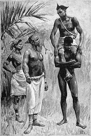
“The court or compound of Casembe—some would call it a palace—is a square enclosure of 300 yards by 200 yards. It is surrounded by a hedge of high reeds. Inside, where Casembe honoured me with a grand reception, stands a gigantic hut for Casembe, and a score of small huts for domestics. The Queen's hut stands behind that of the chief, with a number of small huts also ... Kasembe sat before his hut on an equate seat placed on lion and leopard skins. He was clothed in a coarse blue and white Manchester print edged with red baize, and arranged in large folds so as to look like a crinoline put on wrong side foremost. His arms, legs and head were covered with sleeves, leggings and cap made of various coloured beads in neat patterns: a crown of yellow feathers surmounted his cap ... He then assured me that I was welcome to his country, to go where I liked, and do what I chose. We then went (two boys carrying his train behind him) to an inner apartment, where the articles of my present were exhibited in detail
—extract from The Last Journals of David Livingstone in Central Africa from 1865 To His Death.[2]
1854–1862
VI Chinyanta Munona
1862–70
VII Mwonga Nsemba
Livingstone noted that Mwata Kazembe VII's administration was harsh: A common punishment for court officials was to have the ears cropped by shears. Owing to such tyranny, he would have difficulty raising a thousand men. He observed that the kingdom was not now as prosperous as the Portuguese had reported. The next year he again visited Mwata, who was the first to tell him that the Chambeshi, Lake Bangweulu, the Luapula, Lake Mweru and the Luvua-Lualaba were all one system. This sent Livingstone exploring Bangweulu, then the Lualaba which he thought may flow into the Nile, and Tanganyika, then back to Bangweulu and his death five years later, still trying to discover how its rivers link up and for any evidence that it was part of the Nile rather than the Congo Basin.[2]
Arab and Swahili traders
1870–72
VIII Chinkonkole Kafuti
1872–83 & 1885–86
IX Lukwesa Mpanga
1883–85 & 1886–1904
X Kanyembo Ntemena
In the 18th and 19th centuries Arab and Swahili traders visited Mwata Kazembe to trade in copper, ivory and slaves. Trade routes such as that from Zanzibar via Ujiji on Lake Tanganyika were well established, and the Sultan of Zanzibar's name carried weight. Livingstone was held up southeast of Lake Tanganyika by a conflict between Tippu Tip (Ahmed bin Mohamed, whom Livingstone called Tipo Tipo) and a local chief. When he reached Mwata Kazembe's he found a trader named Mohamad Bogharib had arrived a few days before seeking ivory, and Mohamad bin Saleh (also known as Mpamari), a trader who had been there for ten years, as Mwata had refused to let him leave. Despite their involvement in the slave trade, Livingstone travelled with and was helped by them; he claimed to have used his influence to get Mohamed bin Saleh released.[2]
In 1856, Msiri travelled through Kazembe with a band of followers and requested permission from King Chinyanta Munona to settle among Kazembe's tributary of Garanganza (Katanga). Throughout the 1860s, Kazembe's copper and ivory trade was usurped by Msiri,[1] growing his power with the help of local traders and their descendents, known as bayeke. With the help of the bayeke, Msiri rebelled against the chief of Garanganza and established the Yeke Kingdom. Utilizing gunpowder weapons, Msiri rapidly expanded through former Kazembe territory, carving a large territory for himself and reducing the Kazembe to a small state along Lake Bangwelu, which he held sway over until his death in 1890.[9]
Colonial history
Division between British and Belgian territories
After Msiri's death, the Luapula valley was divided in 1894 between Britain – the eastern shores of the Luapula and Lake Mweru became part of North-Eastern Rhodesia, administered by the British South Africa Company (BSAC) – and King Leopold II of Belgium's misnamed Congo Free State (CFS), or rather its agent, the Compagnie du Katanga, which took over the western shores. The Belgian colonial authorities, having killed Msiri were left with a vacuum. They appointed chiefs – not ones chosen from Msiri's subordinate chiefs (who had previously been subordinate to Mwata Kazembe) – but from what the Luba-Lunda called the 'owners of the land' who had preceded them;[10] there was considerable instability in that part of Katanga as a result. “Belgian administration in Mweru-Luapula was glossed over by a thin veneer of traditional justifications.”[4] This included ‘creating’ a tribe from what was a clan, the Bena Ngoma.
Once Belgian colonial rule was established west of the Luapula, Mwata Kazembe's rule and territory, though not his influence, was confined to the eastern side.
British rule imposed by force
Although Mwata Kazembe X had signed a BSAC mineral concession and a British treaty brought to him by Alfred Sharpe in 1890, and allowed visits by British missionary pioneer Dan Crawford, when the BSAC tax collector Blair Watson took up residence on the Kalungwishi River in 1897, Mwata Kazembe refused to let the British flag be flown over his territory or taxes to be collected from his people, and he defeated an armed incursion by Watson's forces.[4]
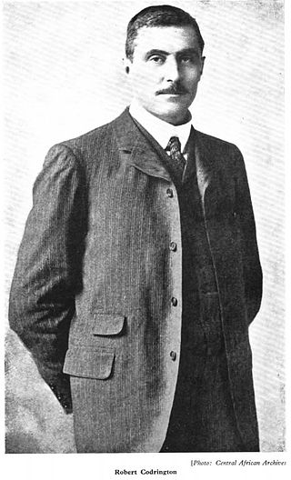
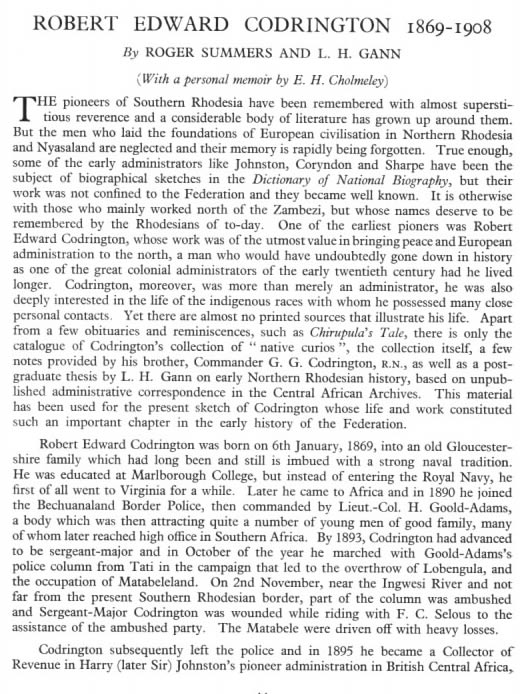
Sharpe by now was governor of the British Central Africa Protectorate (Nyasaland), 1000km away. It was he who had failed to secure Msiri's Garanganza kingdom as a British Protectorate by negotiation, and had later seen it taken from under British noses by the rival CFS through force. In 1899, in conjunction with Robert Codrington, acting BSAC Administrator of North-Eastern Rhodesia, Sharpe sent British officers with Sikh and Nyasaland troops who burnt Mwata Kazembe's capital to the ground, killing a number of his people, though Mwata himself had already escaped across the Luapula.[4]
Mwata Kazembe X made his way south and crossed back over the river to take refuge in the Johnston Falls Mission run by a Mr and Mrs Anderson of Dan Crawford's missionary society. (Ironically, two years before, Mwata Kazembe X had tried to have the Andersons' predecessor at Mambilima, H. J. Pomeroy, killed, but failed.[11][12])
Dan Crawford and Alfred Sharpe had been involved in a similar situation in 1890–91 with Msiri (see that article). At that time Crawford's superior, Charles Swan, had encouraged Msiri to resist Sharpe's British treaty. A year later Msiri was killed by the Belgians, and the region was plunged into chaos. Now, the Andersons responded to Swan differently. While Mr Anderson kept Mwata Kazembe's men at Mambilima, Mrs Anderson took Mwata Kazembe alone to the British officers back at his burnt capital, saying "please be kind to him".[11] Disarmed by this approach and the Mwata's agreement to accept their rule, the British agreed to let him come back.
Mwata Kazembe X rebuilt his capital at Mwansabombwe. The British troops took a number of old and valuable works of art of Luba origin from the court, which they gave to Codrington[citation needed]. In 1920 his heirs placed them in the National Museum of Southern Rhodesia in Bulawayo, 1000km away, where they were listed as the 'Codrington Collection'.[13][14] They are still there.[15]
After the punitive expedition, Mwata Kazembe X and his successors worked with the BSAC and its successors, the British District Commissioners, and to some extent it rescued his chieftainship. The Mwata Kazembes had some influence in the colonial era because the British colonial administration ruled indirectly through chiefs.[4]
The coming of missionaries
With Dan Crawford's influence Mwata Kazembe X readily agreed to requests to establish missions in the valley, especially from the Christian Missions in Many Lands and the London Missionary Society (LMS) which had sent Livingstone to Africa. In 1900 the LMS Mbereshi Mission was established 10km from Mwansabombwe.[16] Here schools, a church and a hospital were established, and brick makers and builders were trained, resulting in the Luapula valley enjoying a higher standard of sun-dried and burnt brick house construction than elsewhere in the region. Other Protestant and Catholic missions established schools and hospitals in the Luapula Valley and on the lake.[16]
Though by the mid-20th century Mwata Kazembe's realm had become overshadowed by the copper mines and industry of Elisabethville (Lubumbashi) and the Copperbelt, through their education gained mostly in mission schools, many Luba-Lunda-Kazembe people made their mark in those towns and in Lusaka, and their experience and influence there flowed back the other way.[16]
Structure of the kingdom
1904–19
XI Mwonga Kapakata
1919–36
XII Chinyanta Kasasa
1936–41
XIII Chinkonkole
Following the Luba kingdom model, Mwata Kazembe as the king has senior chiefs under him, and subordinate chiefs and village headmen under them. The Senior Chiefs are Lukwesa, Kashiba, Kambwali and Kanyembo. Mwata appoints these chiefs from his family and, upon his death, one of these senior chiefs may be promoted to the paramount position. There are also chiefs in neighbouring districts who pay tribute to Mwata Kazembe.[4]
Also following Luba custom, Mwata Kazembe ruled through a council which in colonial times became a 'Superior Native Authority', named in this case the Lunda Native Authority (LNA) to which he appointed a 'cabinet' of advisers who meet under his chairmanship. The LNA was the largest and dominant native authority in the Luapula-Mweru valley. Its work had to be reported to the British District Commissioners who preferred to base themselves in the climate and environment of Kawambwa on the plateau rather than in the heat and mosquitoes of the valley where most of the population lived. It took up a whole day just for quick visit and, in the absence of problems, this allowed the Kazembe chieftainship considerable autonomy.[4]
Functions of the kingdom
Essentially the functions of the kingdom are in the realm of local government, with a stronger emphasis on cultural, social and historical aspects of the life of Kazembe people wherever they may live. The Mwata and his council make regulations in areas not covered by national law or provincial regulations, of land and resource use and management, buildings and infrastructure, employment and occupations, trade and markets, hygiene and health, and traditions and customs including traditional marriage and family life. The Mwata has messengers and guards to enforce regulations, and operates a traditional court to try transgressors; he is also involved in the resolution of disputes.
Modernising the kingdom
1941–50
XIV Shadreck Chinyanta Nankula
1950–57
XV Brown Ngombe
1957–61
XVI Kanyembo Kapema
The Belgian Congo copper-mining town of Elisabethville developed faster than the Northern Rhodesian Copperbelt. Cut off by the Congo Pedicle, the Luapula Province was regarded as a backwater by the Northern Rhodesian government in the first part of the 20th century, so that at first Elisabethville was the most accessible city for the Kazembe, connected as it was by road to the Congolese port of Kasenga on the Luapula, and by boat from there up the river to Lake Mweru. There was migration from the British-administered side to the Belgian one.[4] For further details, see the articles on the Congo Pedicle and Congo Pedicle road.
Mwata Kazembe XIV Shadreck Chinyanta Nankula in the 1940s did much to change this situation. He developed the kingdom and the district, and has been called the first "modernizing" Mwata.[5] He had been educated and employed in Elizabethville and spoke fluent French and English. He galvanised the LNA, changing its name to the Lunda National Association, and appointing to it people with an energy for change and development, like himself. The District Commissioner worried that some of these, such as Dauti Yamba were nationalists who might stir up trouble against the colonial administration, but relationships remained workable.[4] Mwata Kazembe XIV encouraged the building of schools and clinics in Mwansabombwe and the expansion of missions such as Mbereshi. He wrote an account of the chieftainship which was edited by a White Father missionary, Edouard Labreque,[16] and finally published in Chibemba as Ifikolwe Fyandi na Bantu Bandi (My Ancestors and My People)[1] built the current two-storey Mwata's residence but died two days before it was complete.[3]
In the early 1950s, some problems were created across the Luapula when the Luba-Lunda there noted that Mwata Kazembe's courts dispensed justice more to their liking than the Belgians and their chiefs, and asked to be tried for transgressions by the Mwata's courts on the grounds that as Lunda, they had that right, and the local chiefs did not have the authority. But this was not granted.[4]
The modernising of the kingdom was matched by an increase in prosperity as the Pedicle road connected the Luapula Province to the Copperbelt, and fish and labour flowed more easily to that market.
Independence to the present day
1961–83
XVII Paul Kanyembo Lutaba
1983–98
XVIII Munona Chinyanta
1998–
XIX Paul Mpemba Kanyembo Kapale Mpalume
In 1964 Northern Rhodesia became independent Zambia. For a time, chiefs saw their influence overshadowed by party politics and the civil administrations, though in 1985 Mwata Kazembe XVIII was appointed District Commissioner in Kawambwa and later, Provincial Political Secretary.[17]
The fish and labour economic booms in the forties, fifties and sixties gave way to recessions and stagnation from the mid-seventies onwards as fish catches declined, Copperbelt employment contracted and national problems had an effect. However, the construction in the late sixties of the 'Zambia Way', a road connecting Mansa to Nchelenge-Kashikishi through Mwansabombwe, and its surfacing and linking to Kawambwa, Samfya and Serenje over the next two decades, has funnelled trade through Mwansabombwe, the population of which has risen to around 50,000.[17]
The Mwata Kazembe chieftainship has endured and though originating in war and being surrounded by countries that have experienced much conflict, it has presided over peace on the eastern shores of the Luapula and Lake Mweru for more than a century.
Mutomboko Festival
Mwata Kazembe at Mtomboko 2017
In the last two decades the Mwata Kazembe chieftainship has experienced something of a cultural if not an administrative or economic resurgence, through the Mutomboko Festival, now the second largest of its kind in Zambia and a model for the strengthening of indigenous culture.[7][17]
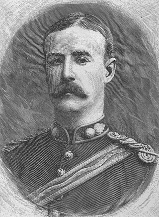
It is held at the end of July and may attract 20,000 visitors, including the president of Zambia.[17] Drawing on previous ceremonies and traditions, it was started in its present form in 1971 to mark the tenth anniversary of the instalment of Mwata Kazembe XVII Paul Kanyembo Lutaba[7] (whose photograph appears at the top of the page). It includes dances symbolising the migration of the Luba-Lunda and the conquest of the Luapula valley by the first chiefs.[7][17]
1 2 3 4 5 6 David M. Gordon (2006). "History on the Luapula Retold: Landscape, Memory and Identity in the Kazembe Kingdom". The Journal of African History. 47: 21. doi:10.1017/S0021853705001283.
1 2 3 4 5 6 7 8 9 10 David Gordon (2000) “Decentralized Despots or Contingent Chiefs: Comparing Colonial Chiefs in Northern Rhodesia and the Belgian Congo.” KwaZulu-Natal History and African Studies Seminar, University of Natal, Durban.
1 2 David M. Gordon (December 2004). "Review of Giacomo Macola. The Kingdom of Kazembe: History and Politics in North-Eastern Zambia and Katanga to 1950". African Studies Review. 47 (3): 216–218. JSTOR1514960.
1 2 3 4 Ruth Kerkham Simbao (2006). "A crown on the move: stylistic integration of the Luba-Lunda complex in Kazembe performance". African Arts. 39 (3): 26. doi:10.1162/afar.2006.39.3.26.
↑ Ian Cunnison (2009). "Kazembe and the Portuguese 1798–1832". The Journal of African History. 2: 61. doi:10.1017/S0021853700002140.
↑ Ian Cunnison (1961). "The Luapula Peoples of Northern Rhodesia: Custom and History in Tribal Politics". Science. 133 (3455): 751. doi:10.1126/science.133.3455.751-a.
↑ Neville Jones (1930s). The Codrington Collection in the National Museum of Southern Rhodesia and the Bembesi Industry.Occasional Papers of National Museum of Southern Rhodesia.
1 2 3 4 Bwalya S Chuba (2000) Mbeleshi in a history of the London Missionary Society, Pula Press.
1 2 3 4 5 Robert Cancel (2006). "Asserting/inventing traditions on the Luapula: the Mutomboko Festival". African Arts. 39 (3): 12. doi:10.1162/afar.2006.39.3.12.
Related Research Articles
Lake Mweru is a freshwater lake on the longest arm of Africa's second-longest river, the Congo. Located on the border between Zambia and Democratic Republic of the Congo, it makes up 110 kilometres (68 mi) of the total length of the Congo, lying between its Luapula River (upstream) and Luvua River (downstream) segments.
This article deals with the disputed area on the borders of the Democratic Republic of the Congo and Zambia, in Luapula Province.
The Luapula River is a north-flowing river of central Africa, within the Congo River watershed. It rises in the wetlands of Lake Bangweulu (Zambia), which are fed by the Chambeshi River. The Luapula flows west then north, marking the border between Zambia and the Democratic Republic of the Congo before emptying into Lake Mweru. The river gives its name to Zambia's Luapula Province.
The pre-colonial history of the modern-day Democratic Republic of the Congo encompasses the history of the Congo Basin region up to the establishment of European colonial rule in the era of New Imperialism and particularly the creation of the Congo Free State and its expansion into the interior after 1885. As the modern territorial boundaries of the Democratic Republic of the Congo did not exist in this period, it is inseparable from the wider pre-colonial histories of Central Africa, the Great Lakes and Rift Valley as well as the Atlantic World and Swahili coast.
Luapula Province is one of Zambia's ten provinces located in the northern part of the country. Luapula Province is named after the Luapula River and its capital is Mansa. As per the 2022 Zambian census, the Province had a population of 1,519,478, which accounted for 7.72 per cent of the total Zambian population.
The Kingdom of Lunda was a confederation of states in what is now the Democratic Republic of Congo, north-eastern Angola, and north-western Zambia. Its central state was in Katanga.
Msiri founded and ruled the Yeke Kingdom in south-east Katanga from about 1856 to 1891. His name is sometimes spelled 'M'Siri' in articles in French. Other variants are "Mziri", "Msidi", and "Mushidi"; and his full name was Mwenda Msiri Ngelengwa Shitambi.
Kazembe is a name used for Mwata Kazembe's town in the Luapula Province of Zambia, especially on maps and in the Zambian postal service. The other name for the town is Mwansabombwe and this is the one used by its or Luba or Chibemba-speaking inhabitants. They may refer in English to "Kazembe's Village" or just "Kazembe", as traditionally a settlement is named after the chief or headman, rather than the location. The Luba-Lunda shared with many tribes the custom of moving to another village or a new site on the death of the chief. Historical references to a village or town may actually be to a different location. For instance when the explorer David Livingstone visited Mwata Kazembe in 1867 and 1868, "Casembe's town", as he wrote it, was further north at the town now called Kanyembo.
The Lunda are a Bantu ethnic group that originated in what is now the Democratic Republic of the Congo along the Kalanyi River and formed the Kingdom of Lunda in the 17th century under their ruler, Mwata Yamvo or Mwaant Yav, with their capital at Musumba. From there they spread widely through Katanga and into Eastern Angola, north-western Zambia and the Luapula valley of Zambia.
Kanyembo is the principal centre of the population on the Mofwe Lagoon, the largest of several lagoons in the Luapula River swamps south of Lake Mweru, in the Luapula Province of Zambia. It takes its name from its traditional ruler, Chief Kanyembo, one of the senior chiefs of the Kazembe-Lunda under Mwata Kazembe. In the past the incumbent Chief has been promoted to Mwata, and Kanyembo was the site of Mwata Kazembe's capital when it was visited by David Livingstone in 1867.
The Mofwe Lagoon is the largest of several lagoons in the Luapula River swamps south of Lake Mweru, in the Luapula Province of Zambia.
The Congo Pedicle is the southeast salient of the Haut-Katanga Province of the Democratic Republic of the Congo, which divides neighbouring Zambia into two lobes. In area, the pedicle is similar in size to Wales or New Jersey. 'Pedicle' is used in the sense of 'a little foot'. 'Congo Pedicle' or 'the Pedicle' is also used to refer to the Congo Pedicle road, which crosses it.
The Congo Pedicle road crosses the Congolese territory of the Congo Pedicle and was constructed by and is maintained by Zambia to connect its Copperbelt and Luapula Provinces. Both the road and the territory may be referred to as ‘the Pedicle’. It is designated as the N36 Route on the Congolese Road Network.
Sir Alfred Sharpe was Commissioner and Consul-General for the British Central Africa Protectorate and first Governor of Nyasaland.
Daniel Crawford, also known as 'Konga Vantu', was a Scottish missionary of the Plymouth Brethren in central-southern Africa.
Robert Edward Codrington was the colonial Administrator of the two territories ruled by the British South Africa Company (BSAC) which became present-day Zambia. He was Administrator of North-Eastern Rhodesia, based at Fort Jameson, now Chipata, from 11 July 1898 to 24 April 1907, and then of North-Western Rhodesia, based at Livingstone from February 1908 to his death in London on 16 December 1908 from heart disease at age 39. He laid the foundation for the amalgamation of the two territories as Northern Rhodesia four years later.
Chiengi or is a historic colonial boma of the British Empire in central Africa and today is a settlement in the Luapula Province of Zambia, and headquarters of Chiengi District. Chiengi is in the north-east corner of Lake Mweru, and at the foot of wooded hills dividing that lake from Lake Mweru Wantipa, and overlooking a dambo stretching northwards from the lake, where the Chiengi rivulet flows down from the hills.
The Garanganze, Yeke or Bayeke are a people of Katanga, in the Democratic Republic of Congo. They established the Yeke Kingdom under the warrior-king Msiri, who dominated the southern part of Central Africa from 1850 to 1891 and controlled the trade route between Angola and Zanzibar from his capital, at Bunkeya.
The Stairs Expedition to Katanga (1891−92), led by Captain William Stairs, was the winner in a race between two imperial powers, the British South Africa Company BSAC and the Congo Free State, to claim Katanga, a vast mineral-rich territory in Central Africa for colonization. The mission became notable when a local chief,, was killed, and also for the fact that Stairs, the leader of one side, actually held a commission in the army of the other.
The Yeke Kingdom of the Garanganze people in Katanga, DR Congo, was short-lived, existing from about 1856 to 1891 under one king, Msiri, but it became for a while the most powerful state in south-central Africa, controlling a territory of about half a million square kilometres. The Yeke Kingdom also controlled the only trade route across the continent from east to west, since the Kalahari Desert and Lozi Kingdom in the south and the Congo rainforest in the north blocked alternative routes. It achieved this control through natural resources and force of arms—Msiri traded Katanga's copper principally, but also slaves and ivory, for gunpowder and firearms—and by alliances through marriage. The most important alliances were with Portuguese–Angolans in the Benguela area, with Tippu Tip in the north and with Nyamwezi and Swahili traders in the east, and indirectly with the Sultan of Zanzibar who controlled the east coast traders.
This page is based on this Wikipedia article Text is available under the CC BY-SA 4.0 license; additional terms may apply. Images, videos and audio are available under their respective licenses.


