Related Research Articles

Trabzon, historically known as Trebizond in English, is a city on the Black Sea coast of northeastern Turkey and the capital of Trabzon Province. Trabzon, located on the historical Silk Road, became a melting pot of religions, languages and culture for centuries and a trade gateway to Persia in the southeast and the Caucasus to the northeast. The Venetian and Genoese merchants paid visits to Trabzon during the medieval period and sold silk, linen and woolen fabric. Both republics had merchant colonies within the city – Leonkastron and the former "Venetian castle" – that played a role to Trabzon similar to the one Galata played to Constantinople. Trabzon formed the basis of several states in its long history and was the capital city of the Empire of Trebizond between 1204 and 1461. During the early modern period, Trabzon, because of the importance of its port, again became a focal point of trade to Persia and the Caucasus.

Trabzon Province is a province of Turkey on the Black Sea coast. Located in a strategically important region, Trabzon is one of the oldest trade port cities in Anatolia. Neighbouring provinces are Giresun to the west, Gümüşhane to the southwest, Bayburt to the southeast and Rize to the east. İsmail Ustaoğlu was appointed the Governor of the province in October 2018.
Pontic Greek is a variety of Modern Greek indigenous to the Pontus region on the southern shores of the Black Sea, northeastern Anatolia, and the Eastern Turkish/Caucasus region. Today it is spoken mainly in northern Greece. Its speakers are referred to as Pontic Greeks or Pontian Greeks.

Hagia Sophia is a formerly Greek Orthodox church which was converted into a mosque in 1584, and located in Trabzon, in the north-eastern part of Turkey. It was converted into a museum in 1964 and back into a mosque in 2013. It dates back to the thirteenth century when Trabzon was the capital of the Empire of Trebizond. It is located near the seashore and two miles west of the medieval town's limits. It is one of a few dozen Byzantine sites extant in the area. It has been described as being "regarded as one of the finest examples of Byzantine architecture."

Gümüşhane Province is a province in northern Turkey, bordering Bayburt to the east, Trabzon to the north, Giresun and Erzincan to the west. It covers an area of 6,575 km2 and has a population of 129,618 in 2010. The population was 186,953 in 2000. The name Gümüşhane means silver house. The city has a rich mining history and was the source of exports for Trabzon. The current Governor is Kamuran Taşbilek, he was appointed on the 27 October 2019.
Gümüşhane is a city and the capital district of Gümüşhane Province in the Black Sea region of Turkey. The city lies along the Harşit River, at an elevation of 5,000 feet (1,500 m), about 40 miles (64 km) southwest of Trabzon. According to the 2010 census, population of Gümüşhane urban center is 28,620. The district covers an area of 1,789 km2 (691 sq mi), and the city lies at an elevation of 1,153 m (3,783 ft).
Komnina is a town in the Kozani regional unit, West Macedonia, Greece. It was the seat of the municipality of Vermio. As of 2011, it had a population of 690 permanent residents. The town's altitude is 688 meters (2260 feet) above sea level.

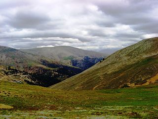
Çaykara is a town and district of Trabzon Province in the Black Sea region of Turkey. As of 2014, the District Mayor of Çaykara is Hanefi Tok (AKP). Çaykara village lies in a V-shaped valley along the Solaklı River in the Pontic Mountains, at an elevation of around 300 metres. Çaykara district lies to the south of Dernekpazarı (Kondu) and forms the upper part of the Of-valley system, with peaks reaching to over 3300 meters. The western half of İkizdere district - which lies just east of Çaykara and is now part of Rize province - was historically also part of the same administrative and cultural region. Large swathes of the district are made up of old-growth temperate broadleaf and mixed forest, gradually making way for alpine tundra at higher altitudes.

Of is a town and district of Trabzon Province in the Black Sea region of Turkey. It is located in the eastern part of Trabzon and is an important historical district of the province. The mayor is Salim Salih Sarıalioğlu (AKP).
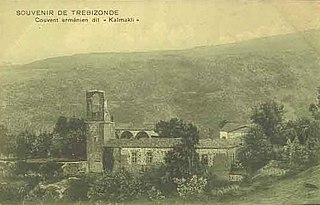
Kaymaklı Monastery is a ruined Armenian Apostolic monastery near Trabzon, Turkey.
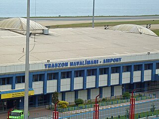
Trabzon Airport is an airport near the city of Trabzon in the eastern Black Sea region of Turkey. The airport opened in 1957. In 2009, it served 1,596,905 passengers, of which most (95%) were on domestic routes. In 2009, Trabzon Airport ranked 9th for total passenger traffic, and 7th for domestic traffic among airports in Turkey.
Boztepe or Mount Minthrion is a hill near Trabzon in Turkey. It is located 3 kilometers southeast of the city center of Trabzon. The Değirmendere Valley lies to the east of Boztepe. The Kaymaklı quarter occupies most of the Boztepe hill.

The Molla Nakip Mosque is a mosque in Pazarkapi district of Trabzon, Turkey.

The Panagia Theoskepastos Monastery, today known in Turkish as Kızlar Monastery, is a former female monastery built during the Empire of Trebizond.
Çağlayan is a town in the central district (Trabzon) of Trabzon Province, Turkey. At 40°54′N39°43′E it is situated along the valley of Altındere creek. It is on Turkish state highway D.885 which connects Trabzon to hinterland. The distance to Trabzon is 16 kilometres (9.9 mi). The population of the town is 4520 as of 2011. The area around Çağlayan was inhabited during the ancient ages. But Çağlayan is a relatively recent settlement. In 1946 owing to its situation along the valley, it was founded as a common market place of the neighbouring villages. It quickly flourished and In 1969 it was declared a seat of township. The economy of the town depends on agriculture. Lately kiwifruit production is promoted.

Ukrainian-Mediterranean Airlines Flight 4230 was a chartered international passenger flight, a Yakovlev Yak-42D operated by Ukrainian UM Airlines, which crashed in 2003.
Coralla or Koralla was a town of ancient Pontus on a cape of the same name. It is placed by Arrian, and the anonymous author of the Periplus, 100 stadia east of Philocaleia, and Philocaleia is 110 stadia east of Tripolis, a well-known position.
Cordyle or Kordyle, also called Portus Chordyle, was a town of ancient Pontus, on the Black Sea coast, 40 or 45 stadia east of Hieron Oros or Yoros. The name occurs in the Tabula Peutingeriana in the form Cordile. There appears to be some confusion in Ptolemy about this place.
Dekaton was a settlement and station of ancient Bithynia on the road east of Nicomedia, 10 Roman miles east of Nicomedia, whence the name.
Malus or Malos was a town of ancient Galatia, inhabited during Roman and Byzantine times. It was the site of the martyrdom of Theodotus of Ancyra.
References
- ↑ "DRIVE TURKS ALONG COAST.; Russians Reach the Kara Dere, 20 Miles from Trebizond". The New York Times . 1916-04-08.
- ↑ Lynne Williams; Anthony Bryer (1997). "Survey in Trabzon and Gümüşhane Vilayets, Turkey, 1992-1994". Dumbarton Oaks Papers . Cambridge: Harvard University Press. 51: 283–289. doi:10.2307/1291767. JSTOR 1291767.
Coordinates: 40°56′18″N40°03′54″E / 40.9384°N 40.0649°E
| | This article about a Black Sea Region of Turkey location is a stub. You can help Wikipedia by expanding it. |
| | This article related to a river in Turkey is a stub. You can help Wikipedia by expanding it. |